This article needs additional citations for verification. Please help improve this article by adding citations to reliable sources. Unsourced material may be challenged and removed. Find sources: "Ohio State Route 51" – news · newspapers · books · scholar · JSTOR(September 2013) (Learn how and when to remove this message)
State Route 51
Route information
Maintained by ODOT
Length
30.76 mi[1] (49.50 km)
Existed
1955–present
Major junctions
South end
US 20 / CR 66 near Elmore
Major intersections
I-80 Toll / I-90 Toll / Ohio Turnpike near Elmore
I-280 in Northwood
US 24 in Toledo
I-475 in Toledo
North end
US 23 / US 223 / SR 184 in Sylvania
Location
Country
United States
State
Ohio
Counties
Sandusky, Ottawa, Wood, Lucas
Highway system
Ohio State Highway System
Interstate
US
State
Scenic
← US 50N
→ US 52
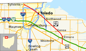
State Route 51 (SR 51) is a northwest-southeast highway (signed north-south) in northwest Ohio. Its southern terminus is at U.S. Route 20 just south of Elmore, Ohio, and its northern terminus is at its interchange, along with State Route 184, at U.S. Route 23 in Sylvania, Ohio. Before an ODOT signage project in 2010, the northern (western) portion of the route, from its northern (western) terminus to the Maumee River was signed as an east-west route. The portion from the Maumee to its southern (eastern) terminus was signed north-south. ODOT has now signed all portions as north-south.
^Ohio Department of Transportation. "Technical Services Straight Line Diagrams - SR 51". Retrieved January 11, 2014.
and 25 Related for: Ohio State Route 51 information
StateRoute51 (SR 51) is a northwest-southeast highway (signed north-south) in northwest Ohio. Its southern terminus is at U.S. Route 20 just south of...
StateRoute 49 (SR 49) is a state highway in the western part of the U.S. state of Ohio. It begins in Drexel, an area within the city of Trotwood, at...
crossing most of northern Ohio. Its western terminus is at the Indiana state line near Hicksville where the route becomes Indiana State Road 37 which continues...
StateRoute 3 (SR 3) is a major north–south (physically northeast-southwest) highway in Ohio which leads from Cincinnati to Cleveland by way of Columbus...
StateRoute 14, located in northeastern Ohio, runs from U.S. Route 6/U.S. Route 42/StateRoute 3 in Downtown Cleveland southeasterly to the Pennsylvania...
of the U.S. state of Ohio. It is the eighth longest stateroute in Ohio, spanning southern Ohio from Cincinnati to Belpre, across the Ohio River from Parkersburg...
StateRoutes in Ohio are owned by the state, and maintained by the state except in cities. They are signed with a white silhouette of Ohio against a black...
longest stateroute in Ohio. Its southern terminus is at U.S. Route 42 in Cincinnati, Ohio, and its northern terminus is at U.S. Route 6 in Sandusky, Ohio. Its...
Uniontown to the Ohiostate line near Darlington, where it connects with OhioStateRoute 14. PA 51 is the termination point for Pennsylvania Route 43, Pennsylvania...
state of Ohio. At about 336 miles (541 km) in length, it is the longest stateroute in Ohio. Its southern terminus is an interchange with U.S. Route 52...
StateRoute 65 (SR 65) is a north–south highway in western Ohio. Its southern terminus is at StateRoute 47 near Sidney, and its northern terminus is at...
StateRoute 18 (SR 18) is an east–west highway in northern Ohio. It is the sixth longest stateroute in the state. Its western terminus is at the Indiana...
StateRoute 126 (SR 126) is a stateroute starting at the Ohio-Indiana border, at a split with StateRoute 129 near Scipio, Ohio, and ending east of Cincinnati...
StateRoute 124 (SR 124) is an east–west state highway in the southern portion of the U.S. state of Ohio. Its western terminus is at StateRoute 134 nearly...
StateRoute 125 (SR 125) is an east–west state highway in the southwestern portion of the U.S. state of Ohio. Its western terminus is within the Cincinnati...
StateRoute 82 (SR 82) is a stateroute in northeastern Ohio, with a western terminus at StateRoute 57 in Lorain County, southeast of Elyria. The route...
StateRoute 28 (SR 28) is an east–west state highway in the U.S. state of Ohio. Both of the route's termini are on U.S. Route 50 (US 50). Its western...
StateRoute 120 (SR 120) is an east–west state highway in the northwestern portion of the U.S. state of Ohio. Its western terminus is at the Michigan state...
StateRoute 184 (SR 184) is a 10.14-mile (16.32 km) long east–west state highway in northwestern Ohio, a U.S. state. The western terminus of SR 184 is...
StateRoute 165 (SR 165) is a 32-mile-long (51 km), primarily east–west running stateroute located in Mahoning and Columbiana counties in northeast Ohio...
 Global Information