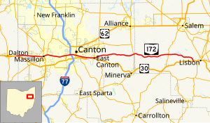
State Route 172 (SR 172) is an east–west state highway in the northeastern portion of the U.S. state of Ohio. Its western terminus is at its interchange with U.S. Route 30 (US 30) about one mile (1.6 km) west of East Greenville near Dalton, and its eastern terminus is at US 30 about two miles (3.2 km) west of Lisbon. The route stays near US 30 for its entire route, and some of the current Route 172 actually served as previous alignments of US 30.
SR 172 was commissioned in 1923, with another section commissioned in 1935 as a different state route number. In the late 1930s the two routes were contacted and made into one route, with the SR 172 designation. The route was extended to the west in the mid-1970s, concurrent with US 30 most of the way. The US 30 designation was removed from some of the concurrency in the mid-1990s.
The Lincoln Highway ran along portions of what is now SR 172 where US 30 also runs or used to run, from its west end to East Canton.
^"DESTAPE". Ohio Department of Transportation. June 24, 2015. Retrieved December 19, 2015.
Wayne County
Stark County
Columbiana County
^Cite error: The named reference ODOT1922_map was invoked but never defined (see the help page).
^Cite error: The named reference ODOT1923_map was invoked but never defined (see the help page).
and 21 Related for: Ohio State Route 172 information
StateRoute172 (SR 172) is an east–west state highway in the northeastern portion of the U.S. state of Ohio. Its western terminus is at its interchange...
StateRoute 21 (SR 21) is a north–south state highway in northeastern Ohio. The southern terminus is north of Strasburg on U.S. Route 250. The northern...
StateRoutes in Ohio are owned by the state, and maintained by the state except in cities. They are signed with a white silhouette of Ohio against a black...
StateRoute 297 (SR 297) is a short north–south state highway in the northeastern portion of the U.S. state of Ohio. Its southern terminus is at a long...
StateRoute 5 (SR 5) is an east–west state highway in the northeastern portion of the U.S. state of Ohio. Its western terminus is at Interstate 76 at its...
state of Ohio. At about 336 miles (541 km) in length, it is the longest stateroute in Ohio. Its southern terminus is an interchange with U.S. Route 52...
StateRoute 43 (SR 43) is a mainly north–south state highway that runs through the northeastern quadrant of the U.S. state of Ohio. Its southern terminus...
StateRoute 435 (SR 435, OH 435) is a 4.084-mile (6.573 km) long east–west state highway in the southwestern portion of the U.S. state of Ohio. The western...
StateRoute 49 (SR 49) is a state highway in the western part of the U.S. state of Ohio. It begins in Drexel, an area within the city of Trotwood, at...
StateRoute 60 (SR 60) is a north–south state highway that runs the entire length of the U.S. state of Ohio, from the Williamstown Bridge over the Ohio...
StateRoute 9 (SR 9) is a north–south route running through four counties in east central Ohio. Its route is 92.5 miles (148.9 km) long. The southern...
StateRoute 241 (SR 241) is a north–south state highway in the northeastern portion of the U.S. state of Ohio. Its southern terminus is at U.S. Route...
(377 km), it is the third longest stateroute in Ohio. The route from Ironton to West Lafayette was once signed as StateRoute 75. In 1962, to eliminate confusion...
StateRoute 44 (SR 44) is a north–south state highway in the northeastern portion of the U.S. state of Ohio. It runs from a southern terminus at State...
StateRoute 687 (SR 687) is a 5.70-mile (9.17 km) long east–west state highway in the northeastern portion of the U.S. state of Ohio. Its western terminus...
StateRoute 66 (SR 66) is a north–south state highway in the northwestern portion of the U.S. state of Ohio. Its southern terminus is at U.S. Route 36...
StateRoute 171 (SR 171) is a west–east state highway located in northeastern Ohio. The highway's western terminus is at a signalized intersection with...
StateRoute 173 (SR 173) is located in northeastern Ohio, and runs east–west from StateRoute 44, about 4 miles (6.4 km) north of Louisville, Ohio to State...
StateRoute 515 (SR 515) is a north-south state highway located in east-central Ohio. Existing entirely within the northeastern portion of Holmes County...
 Global Information