Part of Minnesota, separated from the rest of the state by the Lake of the Woods
This article needs additional citations for verification. Please help improve this article by adding citations to reliable sources. Unsourced material may be challenged and removed. Find sources: "Northwest Angle" – news · newspapers · books · scholar · JSTOR(January 2013) (Learn how and when to remove this message)
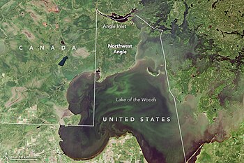
The Northwest Angle in Minnesota, bordering Manitoba, Ontario, and Lake of the WoodsNorthwest Angle from Landsat 8, 2015
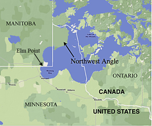
The Northwest Angle, known simply as the Angle by locals, and coextensive with Angle Township, is a pene-exclave of northern Lake of the Woods County, Minnesota. Except for surveying errors,[1] it is the only place in the contiguous United States north of the 49th parallel, which forms the border between the U.S. and Canada from the Northwest Angle westward to the Strait of Georgia (between the U.S. state of Washington and the province of British Columbia). The land area of the Angle is separated from the rest of Minnesota by Lake of the Woods, but shares a land border with Canada. It is one of six non-island locations in the 48 contiguous states that are practical exclaves of the U.S. It is the northernmost township in Minnesota and contains the northernmost point in the contiguous 48 states. The unincorporated community of Angle Inlet is in the Northwest Angle.
Seventy percent of the land of the Angle is held in trust by the Red Lake Indian Reservation (Ojibwa).[2]
Although the Angle is listed as one of several distinct regions of Minnesota, its total population was 119 at the 2010 census.[3] The area is mostly water and the land is mostly forest.
^Jacobs, Frank (November 28, 2011). "A Not-So-Straight Story". Opinionator. Retrieved March 15, 2021.
^"About the Red Lake Indian Reservation". Red Lake Net News. Archived from the original on November 15, 2010.
^"2010 Census Redistricting Data (Public Law 94-171) Summary File - County Subdivision". American FactFinder. United States Census Bureau. Retrieved May 1, 2011.[dead link]
The NorthwestAngle, known simply as the Angle by locals, and coextensive with Angle Township, is a pene-exclave of northern Lake of the Woods County,...
NorthwestAngle Airport (FAA LID: 58MN) is a privately owned, private-use airport located in Angle Inlet, a township in Lake of the Woods County, Minnesota...
NorthwestAngle 33B is a First Nations reserve in Kenora District, Ontario. It is one of three reserves for the NorthwestAngle 33 First Nation. "Northwest...
The NorthwestAngle State Forest is a state forest located in Lake of the Woods County, Minnesota. The name of the forest is derived from its location...
area of Minnesota from the rest of the United States. The NorthwestAngle and the town of Angle Township can be reached from the rest of Minnesota only...
territorial waters), such as Point Roberts, Washington, and Minnesota's NorthwestAngle. A pene-exclave can also exist entirely on land, such as when intervening...
NorthwestAngle 33 First Nation (Ojibwe: Gii-zaagitoowaigamaag) is an Ojibwe or Ontario Anishinaabe First Nation band government who reside in Kenora...
south of the 49th parallel, and parts of the United States (Alaska, NorthwestAngle) are north of it, the term 49th parallel is sometimes used metonymically...
(after Alaska) and northernmost contiguous state, as the isolated NorthwestAngle in Lake of the Woods County is the only part of the 48 contiguous states...
holds most of the NorthwestAngle's land. Whether this change would also include Elm Point, a small cape to the south of the angle but also cut off from...
voted to rejoin the Union less than three months later on 4 July. The NorthwestAngle is a small exclave of Minnesota that juts north into Canada due to...
NorthwestAngle Inlet in Lake of the Woods, Minnesota 49°23′04.1″N 95°9′12.2″W / 49.384472°N 95.153389°W / 49.384472; -95.153389 (NorthwestAngle) –...
road from British Columbia). Other exclaves include Akwesasne, the NorthwestAngle, Point Roberts, and Seaway Island. The status of the waters around...
of Minnesota is the northernmost state outside Alaska; its isolated NorthwestAngle in Lake of the Woods is the only part of the 48 contiguous states lying...
roughly its present shape. A small change in the 1990s brought the NorthwestAngle into the 218 area code; that region had previously been part of Bell...
Animakee Wa Zhing 37 First Nation (formerly NorthwestAngle 37 First Nation, Ojibwe language: Animikii-wajiing, meaning Sacred place of the Thunderbirds)...
the 1818 treaty created a pene-enclave of the United States, the NorthwestAngle, the small section of the present state of Minnesota that is the only...
49.267°N 95.050°W / 49.267; -95.050) is much farther north, in the NorthwestAngle of Lake of the Woods County near the Canada–United States border. It...
through Canada. Point Roberts, Washington; Elm Point, Minnesota; and the NorthwestAngle in Minnesota are three such places. Alburgh, Vermont, is not directly...
Minnesota Coulee Region Iron Range Minnesota River Valley North Shore NorthwestAngle Pipestone Region Red River Valley Southeast Minnesota Twin Cities Metro...
 Global Information