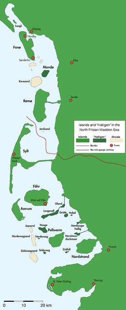
The shoals of the North Frisian Barrier Island are marked with tan colour in the southwestern part of this map
Geography
Location
North Sea
Archipelago
North Frisian Islands
Total islands
3
Major islands
Süderoogsand, Norderoogsand, Japsand
Administration
Germany
State
Schleswig-Holstein
District
Nordfriesland
Demographics
Population
uninhabited
North Frisian Barrier Island is the collective term for three barrier islands (outer shoals) due west of the German Halligen in the North Frisian Islands archipelago. The shoals act as natural breakwater for the Halligen and other islands closer to land. Uninhabited, they remain one of the few areas in the Wadden Sea that are unaffected by direct human activity.
The shoals from north to south are:
No.
sand bank
area km2
1
Japsand
3
2
Norderoogsand
10
3
Süderoogsand
15
North Frisian Barrier Island
28
The shoals are subject to constant change and are slowly moving towards the mainland coast to the east. This changes both their location and surface area. During the last 50 years, all three shoals benefitted from their increasing area but their individual development was very diverse. In total, 43.5 million m3 of sand were eroded by wind and water on the west coasts of the shoals, whereas 32.4 million m3 were deposited at the eastern shorelines. Especially Japsand, which is the youngest and smallest of the three shoals, could thereby gain volume and was the fastest moving shoal. Numerical simulations by the University of Kiel have shown the likelihood of a merger between Japsand and Norderoogsand by 2050. This would cover Hallig Norderoog in sand, as well as large areas of mudflats which are still east of the sands as of today.[1]
The peak heights of the shoals reach about one metre above the average high tide. In summer, the dry sand is sometimes piled to dunes of several metres height. These are occasionally settled by Elymus grasses. Since 1999 though, an increasingly stable and diverse vegetation has been observed at the northern edge of Norderoogsand. The plant carpet helps to accumulate ever more sand, and so the peak dune of Norderoogsand was recorded with 3.50 metres in 2013. Because of this development, Norderoogsand has been called a new island.[2][3]
All three shoals are nature reserves and constitute an important resting area for migratory birds, harbour seals, and grey seals.[2] Together with the Hooger Loch and Rummelloch-West gats, as well the Halligen of Norderoog and Süderoog, the shoals are a popular resort for seals and form one of the main moulting areas of the common eider.[1]
The shoals are part of the core zone of the Schleswig-Holstein Wadden Sea National Park and must not be entered except for the northern areas of Japsand. In 1985, a light beacon was erected on Süderoogsand on a wooden framework.[4] The device is solar powered and has a shelter for shipwrecked sailors.
^ abHofstede, Jacobus L. A. (1998). "Die nordfriesischen Außensände". In Umweltbundesamt und Nationalparkverwaltungen Niedersächsisches Wattenmeer/Schleswig-Holsteinisches Wattenmeer (ed.). Umweltatlas Wattenmeer [Wadden Sea Environmental Atlas]. Vol. 1, Nordfriesisches und Dithmarscher Wattenmeer. Stuttgart: Eugen Ulmer. p. 36. ISBN 3800134918.
^ abRunge, Wolfgang (30 June 2013). "Die neue Insel Norderoogsand ist für Menschen tabu" [The new island Norderoogsand is taboo for humans]. Die Welt (in German). Retrieved 30 June 2013.
^Bojanowski, Axel (3 January 2013). "Nordsee: Neue Vogelinsel erhebt sich im Wattenmeer" [North Sea: New bird island rises in the Wadden Sea]. Der Spiegel (in German). dpa. Retrieved 30 June 2013.
^Rowlett, Russ. "Lighthouses of Germany: North Frisia". The Lighthouse Directory. University of North Carolina at Chapel Hill.
and 23 Related for: North Frisian Barrier Island information
NorthFrisianBarrierIsland is the collective term for three barrierislands (outer shoals) due west of the German Halligen in the NorthFrisian Islands...
The FrisianIslands, also known as the Wadden Islands or the Wadden Sea Islands, form an archipelago at the eastern edge of the North Sea in northwestern...
Louisiana barrierislands. NorthFrisianBarrierIsland Outer Banks Virginia BarrierIslands New York BarrierIslands Texas barrierislands Sea Islands Long...
islands. There are ten German halligen in the NorthFrisianIslands on Schleswig-Holstein's Wadden Sea–North Sea coast in the district of Nordfriesland and...
the Frisianbarrierislands, sees its climate the most moderated by the North- and Wadden Sea. As is the case with the other West Frisianislands, sunshine...
(German pronunciation: [ˈzʏlt] ; Danish: Sild; Söl'ring NorthFrisian: Söl) is a former island in northern Germany, part of Nordfriesland district, Schleswig-Holstein...
and an island with a population of 13,643 in North Holland, Netherlands. It is the largest and most populated island of the West FrisianIslands in the...
of Vordingborg on southern Zealand, Denmark The Halligen in the NorthFrisianIslands, Denmark/Germany Île Aganton in Brittany Île Madame in Charente-Maritime...
to as Frisians and their language as Frisian. Frisian was spoken along the entire southern North Sea coast. By the seventh century, a Frisian Kingdom...
November 24–25, NorthFrisian Flood, severe surge with dike breaches in Denmark. 1982, December 19, the largest negative surge recorded in the North Sea coincided...
located in-between the chain of the seven inhabited East FrisianIslands. Baltrum is the smallest island in this chain by area and inhabitants. It has a land...
worldwide. Low German is most closely related to Frisian and English, with which it forms the North Sea Germanic group of the West Germanic languages...
The cheval de frise (plural: chevaux de frise [ʃə.vo də fʁiz], "Frisian horses") was a defensive obstacle, existing in a number of forms, principally...
Stefanie Bach Stein, called one of her books of poetry Blauort. NorthFrisianBarrierIsland (pdf), (S. 77) Petra Witez: GIS-gestützte Analysen und dynamische...
formed the FrisianIslands. In the micro tidal area, (a tidal range of up to 1.35 meters (4.4 ft), such as on the Dutch or Danish coasts, barrier beaches...
through the row of coastal dunes. The Frisian Isles, originally joined to the mainland, became detached islands in the north. The main rivers, the Rhine and...
According to a 1970 inquiry, West Frisians identified themselves more with the Dutch than with East Frisians or NorthFrisians. A study in 1984 found that 39%...
Frisian, Frankish, Alamannic, Saxon, Thuringian and Burgundian worlds. The important 'Ipswich ware' pottery industry, established in the town's north-east...
began, three dominant Germanic peoples coalesced in the area – Frisians in the north and coastal areas, Low Saxons in the northeast, in addition to the...
Hindenburgdamm or Hindenburg Dam is an 11 km-long causeway joining the NorthFrisianisland of Sylt to mainland Schleswig-Holstein. Its coordinates are 54°53′N...
the north by a roughly straight line between The Wash and the West FrisianIslands going south of the Dogger Bank, a large shallow part in the North Sea...
 Global Information