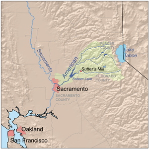
The North Fork American River is the longest branch of the American River in Northern California. It is 88 miles (142 km) long from its source at the crest of the Sierra Nevada, near Lake Tahoe, to its mouth at Folsom Lake northeast of Sacramento.[2] Prior to the construction of Folsom Dam the river was about 9 miles (14 km) longer making for a total length of 97 miles (156 km).
It rises at Mountain Meadow Lake near the 9,008 ft (2,746 m) peak of Granite Chief in the Tahoe National Forest. Flowing initially northwest, the river soon swings west into a gorge, paralleling the Forest Hill Divide on the south. Big Granite Creek then joins the North Fork of the American River coming in from the right. The canyon shallows as the river turns southwest, carving through the Sierra foothills, then turning abruptly south near Colfax. About 4 miles (6.4 km) downstream, it receives Shirttail Creek from the left then is impounded in Lake Clementine (or North Fork Lake) which is formed by the North Fork Dam, built in 1939 to contain hydraulic mining debris.[4]
Below the dam, the river bends south, passing under the Foresthill Bridge, the highest bridge in California, then receives the Middle Fork American River, its largest tributary, from the left. The valley widens as the river flows south past Auburn, soon emptying into the north arm of Folsom Lake, a reservoir formed in 1955 by the Folsom Dam. Its waters merge in the lake with those of the South Fork American River and form the American River, a tributary of the Sacramento River.[4]
^ ab"North Fork American River". Geographic Names Information System. United States Geological Survey, United States Department of the Interior. 1981-01-19. Retrieved 2011-05-21.
^ abU.S. Geological Survey. National Hydrography Dataset high-resolution flowline data. The National Map, accessed 2011-05-21
^ abc"USGS Gage #11434000 on the North Fork American River at Rattlesnake Bar, CA". National Water Information System. U.S. Geological Survey. 1930–1955. Retrieved 2011-05-21.
^ abUSGS Topo Maps for United States (Map). Cartography by United States Geological Survey. ACME Mapper. Retrieved 2009-10-29.
and 24 Related for: North Fork American River information
tributaries, including the NorthForkAmericanRiver, the Middle ForkAmericanRiver, and the South ForkAmericanRiver. The AmericanRiver is known for the discovery...
between the watersheds of the NorthForkAmericanRiver and South ForkAmericanRiver. The Middle Fork joins with the NorthFork near Auburn and they continue...
formed by the Folsom Dam. The NorthForkAmericanRiver also flows into the lake, and the combined rivers form the AmericanRiver proper, which flows from...
The Shenandoah River /ˌʃɛnənˈdoʊə/ is the principal tributary of the Potomac River, 55.6 miles (89.5 km) long with two forks approximately 100 miles (160 km)...
The NorthFork Ninnescah River is a river in the central Great Plains of NorthAmerica. Its entire length lies within the U.S. state of Kansas. It is a...
Bridge or the Auburn Bridge, is a road bridge crossing over the NorthForkAmericanRiver in Placer County and the Sierra Nevada foothills, in eastern California...
impounds the NorthForkAmericanRiverNorthFork Dam (Santa Clara County, California), which impounds the NorthFork Pacheco Creek NorthFork (disambiguation)...
Holston River is a 136-mile (219 km) river that flows from Kingsport, Tennessee, to Knoxville, Tennessee. Along with its three major forks (NorthFork, Middle...
The Clark Fork, or the Clark Fork of the Columbia River, is a river in the U.S. states of Montana and Idaho, approximately 310 miles (500 km) long. The...
Parunaweap Canyon, with the NorthFork Virgin River, that flows from Navajo Lake through Zion Canyon in Zion National Park. The river flows in a southwesterly...
corner of King County. The river starts with the confluence of the NorthFork Skykomish River and South Fork Skykomish River approximately one mile west...
the head of the NorthFork, the river stretches for 157 miles (253 km). The river is colloquially divided into the Upper Mokelumne River, which stretches...
Feather River begins in Lake Oroville, where its four long tributary forks join—the South Fork, Middle Fork, NorthFork, and West Branch Feather Rivers. These...
both sides of the river, including the city of Winnipeg in Canada, as well as the Fargo-Moorhead and Grand Forks–East Grand Forks metropolitan areas...
especially the North and Middle Forks. The Tule River is named for a common bulrush or cattail known as "tule". The present Tule River was named Rio de...
the South Fork Kern River, which drains a high plateau area to the east of the NorthFork drainage. The 95-mile (153 km)-long South Fork rises in Tulare...
Swannanoa River to provide a source of water for Asheville, North Carolina. The city of Asheville purchased 5,000 acres of land in the NorthFork Valley...
Auburn Dam was a proposed concrete arch dam on the NorthFork of the AmericanRiver east of the town of Auburn, California, in the United States, on the...
The NorthFork Wenaha River is a tributary, 16 miles (26 km) long, of the Wenaha River in the U.S. states of Washington and Oregon. The river begins in...
Forks of Waters, the South Branch joins with Strait Creek and flows north across the Virginia/West Virginia border into Pendleton County. The river then...
Brazos. NorthFork Double Mountain Fork Brazos River at the edge of the Llano Estacado Salt Fork Brazos River in Kent County, Texas Double Mountain Fork Brazos...
 Global Information