Wild And Scenic River in California, United States
For the song by Merle Haggard, see Kern River (song).
Kern River
Rio de San Felipe, La Porciuncula, Po-sun-co-la, Porsiuncula River[1]
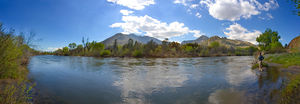
Panorama of the upper Kern River
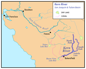
Map of the San Joaquin and Tulare Basin region with the Kern River highlighted. Some rivers shown are intermittent or normally dry. A few selected canals are shown. Below: Map of the San Joaquin and Tulare Basin region showing the old lakes and river courses.
The Kern River, previously Rio de San Felipe, later La Porciuncula, is an Endangered, Wild and Scenic river in the U.S. state of California, approximately 165 miles (270 km) long. It drains an area of the southern Sierra Nevada mountains northeast of Bakersfield. Fed by snowmelt near Mount Whitney, the river passes through scenic canyons in the mountains and is a popular destination for whitewater rafting and kayaking. It is the southernmost major river system in the Sierra Nevada, and is the only major river in the Sierra that drains in a southerly direction.
The Kern River formerly emptied into the now dry Buena Vista Lake and Kern Lake via the Kern River Slough, and Kern Lake in turn emptied into Buena Vista Lake via the Connecting Slough at the southern end of the Central Valley. Buena Vista Lake, when overflowing, first backed up into Kern Lake and then upon rising higher drained into Tulare Lake via Buena Vista Slough and a changing series of sloughs of the Kern River. The lakes were part of a partially endorheic basin that sometimes overflowed into the San Joaquin River.[6] This basin also included the Kaweah and Tule Rivers, as well as southern distributaries of the Kings River that all flowed into Tulare Lake.
Since the late 19th century the Kern has been almost entirely diverted for irrigation, recharging aquifers, and the California Aqueduct, although some water empties into Lake Webb and Lake Evans, two small lakes in a portion of the former Buena Vista Lakebed. The lakes were created in 1973 for recreational use. The lakes hold 6,800 acre⋅ft (8,400 dam3) combined.[7] Crops are grown in the rest of the former lakebed. In extremely wet years the river will reach the Tulare Lake basin through a series of sloughs and flood channels.
Despite its remote source, nearly all of the river is publicly accessible. The Kern River is particularly popular for wilderness hiking and whitewater rafting. The Upper Kern River is paralleled by trails to within a half-mile of its source (which lies at 13,600 feet (4,100 m)). Even with the presence of Lake Isabella, the river is perennial down to the lower Tulare Basin. Its swift flow at low elevation makes the river below the reservoir a popular location for rafting.
^Cite error: The named reference Gudde was invoked but never defined (see the help page).
^ abcdU.S. Geological Survey Geographic Names Information System: Kern River, GNIS
^Google Earth elevation for GNIS coordinates.
^"Boundary Descriptions and Names of Regions, Subregions, Accounting Units and Cataloging Units". U.S. Geological Survey. Retrieved August 22, 2010.
^ abWater Resources Data California, Water Year 2004, Volume 3, USGS
^ECORP Consulting, Inc. (2007), Tulare Lake basin hydrology and hydrography: a summary of the movement of water and aquatic species(PDF), U.S. Environmental Protection Agency, retrieved May 4, 2011
The KernRiver, previously Rio de San Felipe, later La Porciuncula, is an Endangered, Wild and Scenic river in the U.S. state of California, approximately...
The KernRiver Valley is a valley and region of the Southern Sierra Nevada, in Kern County, California. The valley was inhabited for millennia by the...
The KernRiver Canyon is a canyon in Kern County, California. It is located in the Southern Sierra Nevada. The canyon was formed by the KernRiver and...
The KernRiver Oil Field is a large oil field in Kern County in the San Joaquin Valley of California, north-northeast of Bakersfield in the lower Sierra...
KernRiver Pipeline is a 1,679-mile (2,702 km) long natural gas pipeline line extending from southwestern Wyoming to its terminus near Bakersfield, California...
Look up kern in Wiktionary, the free dictionary. Kern or KERN may refer to: Kern (surname), includes a list of people with the name Kern (soldier), a light...
Trout Creek (tributary to the KernRiver), Volcano Creek (tributary to Golden Trout Creek), and the South Fork KernRiver. The Golden trout is the official...
the KernRiver golden trout of Southern California, hatchery-bred rainbows introduced into the KernRiver have diluted the genetic purity of the Kern River...
National Park (listed north to south): The 25 groves in the Tule River, KernRiver, and Deer Creek watersheds are mostly in Giant Sequoia National Monument...
South Fork KernRiver is a tributary of the KernRiver in the Sierra Nevada of the U.S. state of California. It is one of the southernmost rivers on the western...
Pine Creek Middle Fork Tule River North Fork Middle Fork Tule River Alder Creek South Fork Middle Fork Tule RiverKernRiver Cottonwood Creek Lucas Creek...
The KernRiver rainbow trout (Oncorhynchus mykiss gilberti) is a localized subspecies of the rainbow trout (Oncorhynchus mykiss), a variety of fish in...
instrumental in the development of 3 of California's billion barrel oil fields: KernRiver, Midway-Sunset, and South Belridge. With his partner Burton Green and...
first of the lakes fed by the KernRiver. Kern Lake is now a dry lake bed, due to agricultural diversion of the KernRiver waters and the aquifer. Lake...
The KernRiver Parkway is primarily a natural preserve in Bakersfield, California. It runs the length of the KernRiver from the mouth of the Kern Canyon...
Audubon KernRiver Preserve is a riparian nature reserve owned by the National Audubon Society in the US state of California, near Weldon in Kern County...
The Little KernRiver is a 24.4-mile-long (39.3 km) major tributary of the upper KernRiver in the Sequoia National Forest, in the southern Sierra Nevada...
150-acre (61 ha) KernRiver Valley Campus is located in the KernRiver Valley, within the town of Lake Isabella, California. The KernRiver Valley Campus...
located on the banks of the KernRiver near Bodfish, California and Lake Isabella in the Sequoia National Forest in Kern County. There are four rock and...
project. Constructed between 1921 and 1936, it is the oldest section of the KernRiver County Park. The origins of the park date back to 1921, when County Supervisor...
The KernRiver Beds Formation is a Neogene Period geologic formation in the southeastern San Joaquin Valley, within Kern County, California. The Kern River...
 Global Information