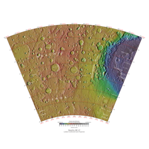
Map of Noachis quadrangle from Mars Orbiter Laser Altimeter (MOLA) data. The highest elevations are red and the lowest are blue.
Coordinates
47°30′S330°00′W / 47.5°S 330°W / -47.5; -330
Image of the Noachis Quadrangle (MC-27). The northeast includes the western half of Hellas basin. The southeastern region contains Peneus Patera and part of the Amphitrites volcano.
The Noachis quadrangle is one of a series of 30 quadrangle maps of Mars used by the United States Geological Survey (USGS) Astrogeology Research Program. The Noachis quadrangle is also referred to as MC-27 (Mars Chart-27).[1]
The Noachis quadrangle covers the area from 300° to 360° west longitude and 30° to 65° south latitude on Mars. It lies between the two giant impact basins on Mars: Argyre and Hellas. The Noachis quadrangle includes Noachis Terra and the western part of Hellas Planitia.
Noachis is so densely covered with impact craters that it is considered among the oldest landforms on Mars—hence the term "Noachian" for one of the earliest time periods in martian history.
In addition, many previously buried craters are now coming to the surface,[2] where Noachis' extreme age has allowed ancient craters to be filled, and once again newly exposed.
Much of the surface in Noachis quadrangle shows a scalloped topography where the disappearance of ground ice has left depressions.[3]
The first piece of human technology to land on Mars landed (crashed) in the Noachis quadrangle. The Soviet's Mars 2 crashed at 44°12′S313°12′W / 44.2°S 313.2°W / -44.2; -313.2. It weighed about one ton. The automated craft attempted to land in a giant dust storm. To make conditions even worse, this area also has many dust devils.[4]
^Davies, M.E.; Batson, R.M.; Wu, S.S.C. "Geodesy and Cartography" in Kieffer, H.H.; Jakosky, B.M.; Snyder, C.W.; Matthews, M.S., Eds. Mars. University of Arizona Press: Tucson, 1992.
^Mars Space Flight Facility (17 March 2004). "Exhumed Crater (Released 17 March 2004)". Arizona State University. Archived from the original on 27 September 2011. Retrieved 19 December 2011.
^Lefort, A.; et al. (2010). "Scalloped terrains in the Peneus and Amphitrites Paterae region of Mars as observed by HiRISE". Icarus. 205 (1): 259–268. Bibcode:2010Icar..205..259L. doi:10.1016/j.icarus.2009.06.005.
^Hartmann, W. 2003. A Traveler's Guide to Mars. Workman Publishing. NY, NY.[page needed]
and 24 Related for: Noachis quadrangle information
Mars: Argyre and Hellas. The Noachisquadrangle includes Noachis Terra and the western part of Hellas Planitia. Noachis is so densely covered with impact...
350°E / -45; 350. It is in the Noachisquadrangle. The term "Noachian epoch" is derived from this region. A crater in Noachis Terra. The dunes here are linear...
this image are enlarged in following images. The location is the Noachisquadrangle Polygons, as seen by HiRISE under HiWish program Close view of polygons...
basalt) which form a dark spot in Noachisquadrangle. Picture from Mars Global Surveyor. Wide view of dunes in Noachis, as seen by HiRISE Close-up View...
Surveyor under the MOC Public Targeting Program. Image is located in the Noachisquadrangle. Lava flows were once covered over, now these platy flows are being...
including in Arabia Terra (Arabia quadrangle), northern Meridiani Planum, Solis Planum, Noachis Terra (Noachisquadrangle), Atlantis Chaos, and Nepenthes...
It is in the Noachisquadrangle and the southeasternmost area of Noachis Terra, and is located midway between the highland area of Noachis and the impact...
the Hellas basin. The type area of the Noachian System is in the Noachisquadrangle (MC-27) around 40°S 340°W / 40°S 340°W / -40; -340. At a large...
Location is Noachisquadrangle. Ophir Chasma Wall. Location is Coprates quadrangle. Tithonium Chasma. Location is Coprates quadrangle. Layers west of...
crater in Phaethontis quadrangle, as seen by HiRISE under HiWish program Spatulate depressions are visible. Gullies in Noachisquadrangle, as seen by HiRISE...
tsunamis affected some surfaces in the Ismenius Lacus quadrangle and in the Mare Acidalium quadrangle. In July 2019, support was reported for an ancient...
Peneus Patera is a feature in the Noachisquadrangle of Mars. It is located at 58.1 S and 307.5 W. It was named after an albedo feature at 48S, 290W. Peneus...
Frento Vallis is a valley in the Noachisquadrangle of Mars, with a location centered at 50.3 S and 14.5 W. It is 277 km long and was named after the classical...
has been divided into thirty cartographic quadrangles by the United States Geological Survey. Each quadrangle is a region covering a specified range of...
The Tharsis quadrangle is one of a series of 30 quadrangle maps of Mars used by the United States Geological Survey (USGS) Astrogeology Research Program...
The Aeolis quadrangle is one of a series of 30 quadrangle maps of Mars used by the United States Geological Survey (USGS) Astrogeology Research Program...
The Ismenius Lacus quadrangle is one of a series of 30 quadrangle maps of Mars used by the United States Geological Survey (USGS) Astrogeology Research...
The Memnonia quadrangle is one of a series of 30 quadrangle maps of Mars used by the United States Geological Survey (USGS) Astrogeology Research Program...
Research Program. The Argyre quadrangle is also referred to as MC-26 (Mars Chart-26). It contains Argyre Planitia and part of Noachis Terra. The word Argyre...
ridges, TAR's are visible and labeled. Location is Hellas Planitia in Noachisquadrangle. Close, color view of unusual transverse aeolian ridges, TAR's, as...
pattern and mantle. Location is Hellas quadrangle. Dissected Mantle with layers. Location is Noachisquadrangle. Surface showing appearance with and without...
regions of Mars: Sinai Planum, Solis Planum, Thaumasia Planum, Lunae Planum, Noachis Terra, and Xanthe Terra. The name Coprates refers to Coprates Chasma, a...
HiRISE under HiWish program. Russell Crater Dust Devil Changes in Noachisquadrangle, as seen by HiRISE. Click on image to see changes in dust devil tracks...
 Global Information