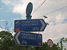
National Route 72 of the National Cycle Network, in Northern England is also called "Hadrian's Cycleway". It starts at Kendal and makes its way around the Cumbrian coast via Barrow-in-Furness and Whitehaven to Silloth, and then across the country through Carlisle via Newcastle upon Tyne to Tynemouth at the northern shore or to South Shields at the Tyne's south shore, where the cycleway ends at Arbeia Roman Fort. Much of its route is very close to Hadrian's Wall.
Kendal to Barrow in Furness is mapped on the Walney To Wear map. Ravenglass to Tynemouth is open and mapped on the Hadrian's Cycleway map, though some sections between Ravenglass and Silloth are using interim routes.
v
t
e
Sustrans' National Cycle Network
List of routes
Main routes
1
2
3
4
5
6
7
8
9
National routes
10
11
12
13
14
15
16
17
18
20
21
22
23
24
25
26
27
28
32
33
34
41
42
43
44
45
46
47
48
50
51
52
53
54
55
56
57
60
61
62
63
64
65
66
67
68
69
70
71
72
73
74
75
76
77
78
81
82
84
85
88
91
92
93
94
95
96
Regional routes
125
136
137
141
151
155
162
164
165
166
167
168
169
172
174
177
178
179
195
196
207
208
212
221
222
223
224
231
232
235
236
244
246
248
250
253
254
255
256
264
267
270
272
273
274
275
276
277
278
305
326
334
338
339
341
344
403
410
413
416
423
425
426
436
437
438
439
440
442
446
447
448
451
455
461
465
466
467
468
469
475
476
477
478
481
482
485
492
523
524
525
526
533
534
535
536
539
544
547
548
549
550
552
554
555
558
559
561
562
566
568
573
576
577
585
622
627
633
636
645
646
647
648
656
657
658
665
668
672
674
677
680
688
689
696
697
699
700
715
725
753
754
756
764
765
766
767
768
775
776
777
780
810
811
818
819
820
822
825
862
881
882
883
884
885
887
Named routes
C2C
Celtic Trail
Clyde to Forth
Colliers Way
Cornish Way
Darent Valley Path
Forth and Clyde Canal Pathway
Hadrian's Cycleway
Heron Trail
Keelmans Way
Lôn Cambria
Lôn Las Ogwen
Pennine Cycleway
Mercian Way
The North West Trail
Salmon Run cycle route
Scunthorpe Ridgeway
Sheerness Way
Trans Pennine Trail
Viking Coastal Trail
Way of the Roses
White Rose cycle route
W2W
Yorkshire Wolds cycle route
and 30 Related for: National Cycle Route 72 information
Sea to Sea CycleRoute (C2C) is a 140 miles (230 km) cycleroute opened in 1994. Combining sections of NationalCycleRoute 7, 14, 71 and 72; it runs from...
NationalCycle Network (NCN) Route 141 is a Sustrans Regional Route. It is 11.2 km (7.0 mi) long. It provides a connection between Route 14 and Route...
traffic-calmed routes in towns and cities. The Bristol and Bath Railway Path (now part of NationalRoute 4) is a 14-mile (23 km) walking and cycling path on...
NationalCycle Network (NCN) Route 165 is a Sustrans NationalRoute that runs from Barnard Castle to Whitby. The route is 116 km (72 miles) long and is...
database (1380276)". National Heritage List for England. Historic England. "Details from listed building database (1248569)". National Heritage List for...
of routes on Sustrans's NationalCycle Network within the United Kingdom. As the cycle network has not been fully completed, some sections of routes are...
NationalCycle Network (NCN) Route 10 is a Sustrans NationalRoute that runs from Cockermouth to North Shields in the United Kingdom. The route is 217 km...
NationalCycle Network (NCN) Route 71 is a Sustrans NationalRoute that runs from Whitehaven and Workington on the Cumbrian coast to Kirby Knowle in North...
It is popular spot for salmon fishing, walking and cycling as it is on the NationalCycleRoute72. Hagg Bank Hill is a notorious one for walkers, runners...
NationalCycle Network (NCN) Route 65 is a Sustrans NationalRoute that runs from Hornsea on the North Sea Coast of The East Riding of Yorkshire via Hull...
the cycleroute diverges from the railway to head south east, past Percy Main Metro, on its way to meet the east–west running NationalCycleRoute72 which...
The Walney to Wear and Whitby CycleRoute (or W2W) is the name of a cross-country cycleroute in Northern England. It runs from Walney Island in Cumbria...
NationalCycle Network (NCN) Route 657 is a loop of the White Rose cycleroute, NCN 65. It branches off the main route to connect the town of Thirsk to...
woodland in a steep-sided valley with Dewley Burn running through. Nationalcycleroute72 passes through South Throckley, along the edge of the River Tyne...
NationalCycle Network (NCN) Route 648 is a Sustrans NationalRoute that connects Bakewell to Sherwood Forest. The route has opened between Sherwood Forest...
NationalCycle Network (NCN) Route 656 is a Sustrans regional route in North Yorkshire. A 18.5 miles (29.8 km) cycle way between Coxwold and a junction...
NationalCycle Network (NCN) Route 658 is a Sustrans Regional Route. It is two miles (3.2 km) long, and provides a connection between Route 65 and Route...
NationalCycle Network (NCN) Route 69 is a Sustrans NationalRoute that runs from Hest Bank to Cleethorpes. The route is incomplete and consists of one...
NationalCycle Network (NCN) Route 76 is a Sustrans NationalRoute that runs from Berwick-upon-Tweed to Kirkcaldy. The route is 168 miles (270 km) in length...
NationalCycle Network (NCN) Route 169 is a Sustrans Regional Route that runs through Scunthorpe . It is 5 miles (8.0 km), fully open and signed. It is...
NationalCycle Network (NCN) Route 166 is a Sustrans regional route in the Yorkshire Wolds between Kirkham and Hunmanby. It is one of 5 NCN routes that...
century, the railway tracks across the structure had been removed. NationalCycleRoute 141 passes underneath the Scotswood Railway Bridge along the north...
NationalCycle Network (NCN) Route 167 is a Sustrans regional route in the Yorkshire Wolds between Kirkham and Huggate. It is one of 5 NCN routes that...
NationalCycle Network (NCN) Route 688 is a Sustrans NationalRoute that runs from Winterburn to Linton-on-Ouse. It is 55 miles (89 km), fully open and...
 Global Information