Area of dangerously shallow water in the Atlantic Ocean
Detail from NOAA nautical chart 12300 showing the Nantucket Shoals in relation to Nantucket Island.
Nantucket Shoals is an area of dangerously shallow water in the Atlantic Ocean that extends from Nantucket Island, Massachusetts, eastward for 23 miles (37 km) and southeastward for 40 miles (64 km); in places water depth can be as shallow as 3 feet (0.91 m).[1] Depth soundings are unpredictable due to the constant change caused by strong currents, which are rotary rather than reversing.[2] The shoals lie just off of a major transatlantic shipping lane. Numerous ships have been wrecked here, most recently and notably the oil tanker Argo Merchant in December 1976. Until 1983, the edge of the shoals was guarded by the Nantucket Lightship.
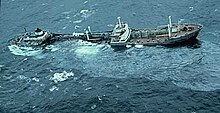
The oil tanker Argo Merchant aground on Middle Rip, December 15, 1976.
Nantucket Shoals is made up of the following features:[3]
Asia Rip
Davis Bank
Fishing Rip
Middle Rip
Phelps Bank
According to the 2010 edition of the United States Coast Pilot, the International Maritime Organization has established an "area to be avoided" for the Nantucket Shoals. Vessels transporting oil or hazardous materials and vessels of more than 1,000 gross tons should avoid the area bounded by the points in the below table.[1]
41°23′24″N70°02′48″W / 41.39°N 70.046667°W / 41.39; -70.046667 (Great Point Light)
^ abUnited States Coast Pilot. Vol. 2 (39th ed.). Washington, D.C.: National Ocean Service. 2010. pp. 178–179. Archived from the original on May 27, 2010. Retrieved April 17, 2010.
^Le Lacheur, Embert A. (April 1924). "Tidal Currents in the Open Sea: Subsurface Tidal Currents at Nantucket Shoals Light Vessel". Geographical Review. 14 (2): 282–286. doi:10.2307/208104. JSTOR 208104.
^United States Coast Pilot. Vol. 2 (39th ed.). Washington, D.C.: National Ocean Service. 2010. pp. 179–180. Retrieved April 17, 2010.
December 1976. Until 1983, the edge of the shoals was guarded by the Nantucket Lightship. NantucketShoals is made up of the following features: Asia...
named Nantucket or NantucketShoals was served by a number of lightvessels (also termed lightships) that marked the hazardous NantucketShoals south of...
flow) completes a full rotation in 12+1⁄2 hours (for example, the NantucketShoals). In addition to oceanic tides, large lakes can experience small tides...
of the coast of Nantucket, Massachusetts, in 80 feet of water. The tower was closed in 1963 and dismantled. Located in NantucketShoals, Texas Tower 3...
aboard the Lightship stationed on the NantucketShoals. The first Lightship Station on the Nantucket Island Shoal was established in June 1854 and crewed...
Service. The French Frigate Shoals are about 487 nautical miles (902 km; 560 mi) northwest of Honolulu. Among the shoals are Tern, which is unique in...
(1709–1730s) of offshore sperm whaling. Instead, sloops concentrated on the NantucketShoals, where they would have taken right whales or went to the Davis Strait...
Davis Bank may refer to: Davis Bank (Nantucket), a feature of NantucketShoals in Massachusetts, USA. Davis Bank (Belize), a former estate in Belize City...
on a rhumb line leg of 1,023 nautical miles (1,177 mi; 1,895 km) to NantucketShoals Light when making fatal contact with an iceberg. The final leg of the...
migration may occur with changes in the water temperatures around the NantucketShoals and Georges Bank during the winter or spring, but this theory has no...
service in the United States until March 29, 1985, when the last ship, the Nantucket I, was decommissioned. During that period, lightships were operated by...
Atlantic is the Great South Channel, located between Georges Bank and the NantucketShoals. The watershed of the gulf encompasses an area of 69,000 square miles...
Radar Squadron North Truro Air Force Station decommissioned 1963 TT-3 NantucketShoals 40°45′00.00″N 69°19′0.00″W / 40.7500000°N 69.3166667°W / 40.7500000;...
service 1928 to 1956 Nantucket, in service 1957 to 1974 Nantucket, in service since 1974 "Nantucket"is a lightship station marking the shoals south of the island...
second day out labouring in heavy seas in the dangerous area between NantucketShoals and Georges Bank. She was not seen again. Among the passengers was...
(9.7 km) through the shoals and is 30 feet (9.1 m) deep and 2,000 feet (610 m) wide. It was completed in 1925. "Pollock Rip Shoals". Missions. U.S. Army...
66-ton fishing schooner Natalie B. Nickerson in thick fog near the NantucketShoals. The schooner sank and three of her crew of eighteen lost their lives;...
Radar Squadron North Truro Air Force Station decommissioned 1963 TT-3 NantucketShoals 40°45′00.00″N 69°19′0.00″W / 40.7500000°N 69.3166667°W / 40.7500000;...
Printing Office. 1872. p. 490. Retrieved 2012-09-28. From Monomoy and NantucketShoals to Muskeget Channel, Mass (Map). 1:80,000. Department of Commerce....
second day out laboring in heavy seas in a dangerous area between NantucketShoals and Georges Bank and was not seen again. 136 1890 United Kingdom RMS Quetta...
 Global Information