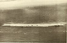
French Frigate Shoals, 2003The towering La Pèrouse Pinnacle is made of hard volcanic rock and rises 122 ft (37 m)Tern Island, the famous coral carrier, was made into an airstrip base after the Battle of Midway in World War II
The French Frigate Shoals (Hawaiian: Kānemilohaʻi) is the largest atoll in the Northwestern Hawaiian Islands. Its name commemorates French explorer Jean-François de Galaup, comte de Lapérouse, who nearly lost two frigates when attempting to navigate the shoals. It consists of a 20-mile-long (32 km) crescent-shaped reef, twelve sandbars, and the 120-foot-high (37 m) La Perouse Pinnacle, the only remnant of its volcanic origins. The total land area of the islets is 61.508 acres (24.891 ha), while the total coral reef area of the shoals is over 232,000 acres (94,000 ha). Tern Island, with an area of 26.014 acres (10.527 ha), has a landing strip and permanent habitations for a small number of people. It is maintained as a field station in the Hawaiian Islands National Wildlife Refuge by the United States Fish and Wildlife Service. The French Frigate Shoals are about 487 nautical miles (902 km; 560 mi) northwest of Honolulu. Among the shoals are Tern, which is unique in having an airstrip and is protected by a seawall, and La Perouse Pinnacle, a tall and rocky island in the center of the shoals. The two largest islands after Tern, East and Trig have mostly washed away, with East being about half the size from storms, but are famed as breeding grounds for turtles. East was also home to Coast Guard base in the late 20th century. The islands are surrounded by a coral reef, and the islands themselves are noted breeding ground for turtles, seals, and birds. Habitation is difficult with little vegetation and no fresh water. In the 20th century the French Frigate Shoals are also called Lalo as part of the marine nature reserve, and along with other islands are visited periodically for research. The highest point in the shoals is on La Perouse Pinnacle which is a volcanic rock that rises 122 ft (37 m) above the surrounding lagoon.[1][2]
In the 20th century, the shoals were used by the Imperial Japanese Navy as part of an operation to attack Hawaii. Afterwards, a small United States Navy base was established there to prevent it from being used again. After the war it was used by the United States Coast Guard for a LORAN radio navigation station. By the 21st century, it was primarily used for oceanographic and biological study as a nature reserve. Studies at the island helped establish the nature of plastic pollution, and in 2020 one island was designated as contaminated by plastic pollution from the ocean. The reefs are noted for having survived many Pacific storms, although these storms have damaged facilities, wildlife, and significantly reduced the area of some islands.
^"Papahānaumokuākea Marine National Monument". www.papahanaumokuakea.gov. Retrieved 7 September 2023.
^Stanley, David (1985). South Pacific Handbook. Moon publications. p. 549. ISBN 9780918373052.
and 22 Related for: French Frigate Shoals information
14611 The FrenchFrigateShoals (Hawaiian: Kānemilohaʻi) is the largest atoll in the Northwestern Hawaiian Islands. Its name commemorates French explorer...
FrenchFrigateShoals Airport (ICAO: PHHF, FAA LID: HFS) is a private use airport on Tern Island in FrenchFrigateShoals, a coral atoll, in Hawaii, United...
plans called for the use of five H8K aircraft. They would fly to FrenchFrigateShoals, the largest atoll in the Northwestern Hawaiian Islands, to be refueled...
(FrenchFrigateShoals)... At twilight after the burst, resonant scattering of light from lithium and other debris was observed at Johnston and French...
fishing nets and a discarded toothbrush. Ingestion of plastic flotsam can be an increasing health risk to albatrosses. Tern Island, FrenchFrigateShoals....
separate islands (but also names smaller island chains such as the FrenchFrigateShoals, which includes 13 islands of its own). Some of these are too small...
scattering, in materials science Hyperfine structure, in physics FrenchFrigateShoals Airport, in Hawaii, United States Hagfors Airport, in Sweden Hatfield...
FFS Arena, in Lund, Sweden Frankfurt South station, in Germany FrenchFrigateShoals, an island in the Northwestern Hawaiian Islands Facial feminization...
issued for Nihoa to FrenchFrigateShoals to Maro Reef. Later in the day, a hurricane warning was issued for FrenchFrigateShoals to Maro Reef and a tropical...
588 mi) northwest of Honolulu and 108 miles (94 nmi; 174 km) from FrenchFrigateShoals. The total area of the two small islets, remnants of an ancient...
parties, or may come from Portuguese né? (shortened from "não é?"), cf. French n'est-ce pas ?. Eh? may also have come from English yeah. Senator Inouye...
mature birds estimated in 2006. Midway Atoll, Laysan Island, and the FrenchFrigateShoals have more than 90% of the breeding pairs at 551,940. Bonin Island...
Great frigatebirds marked with wing tags on Tern Island in the FrenchFrigateShoals were found to regularly travel the 873 km (542 mi) to Johnston Atoll...
Island on Tern Island, FrenchFrigateShoals in Lualualei ammunition depot. FrenchFrigateShoals FPO# 80, now FrenchFrigateShoals Airport, Naval Auxiliary...
minesweeper to guard the intended refueling point for Operation K near FrenchFrigateShoals, causing the reconnaissance mission to be aborted and leaving Yamamoto...
through the burst area to far north of the north conjugate area (FrenchFrigateShoals). ... At twilight after the burst, resonant scattering of light...
discovered that the intended refueling point—a hitherto deserted bay off FrenchFrigateShoals—was now occupied by American warships because the Japanese had carried...
 Global Information