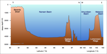
Profile of the Arctic Ocean from the Barents Sea towards the (geographic) North Pole
The Nansen Basin (also Central Basin,[1] formerly Fram Basin) is an abyssal plain with water-depths of around 3 km in the Arctic Ocean and (together with the deeper Amundsen Basin) part of the Eurasian Basin. It is named after Fridtjof Nansen. The Nansen Basin is bounded by the Gakkel Ridge on the one side and by the Barents Sea continental shelf on the other.[2][3]
The lowest point of the Arctic Ocean lies within the Nansen Basin and has a depth of 4,665 m.[4] The Barents Abyssal Plain is located at the center of the Fram Basin.[5]
^Nordenskjöld, Otto; Ludwig Mecking; Ernst Antevs; Wolfgang Louis Gottfried Joerg; Marion Hale (1928). The Geography of the Polar Regions. American Geographical Society. pp. 126.
^"International Bathymetric Chart of the Arctic Ocean". NOAA.
^Jakobsson, Martin; Mayer, Larry; Coakley, Bernard; Dowdeswell, Julian A.; Forbes, Steve; Fridman, Boris; Hodnesdal, Hanne; Noormets, Riko; Pedersen, Richard; Rebesco, Michele; Schenke, Hans Werner; Zarayskaya, Yulia; Accettella, Daniela; Armstrong, Andrew; Anderson, Robert M.; Bienhoff, Paul; Camerlenghi, Angelo; Church, Ian; Edwards, Margo; Gardner, James V.; Hall, John K.; Hell, Benjamin; Hestvik, Ole; Kristoffersen, Yngve; Marcussen, Christian; Mohammad, Rezwan; Mosher, David; Nghiem, Son V.; Pedrosa, Maria Teresa; Travaglini, Paola G.; Weatherall, Pauline (29 June 2012). "The International Bathymetric Chart of the Arctic Ocean (IBCAO) Version 3.0". Geophysical Research Letters. 39 (12): n/a. Bibcode:2012GeoRL..3912609J. doi:10.1029/2012GL052219. hdl:2445/175672.
^"Arctic Ocean". CIA World Factbook. Central Intelligence Agency. Retrieved 2009-07-28.
^"Towering Mountains". Canada's Aquatic Environments. CyberNatural Software, University of Guelph. Retrieved 2009-07-28.
The NansenBasin (also Central Basin, formerly Fram Basin) is an abyssal plain with water-depths of around 3 km in the Arctic Ocean and (together with...
the NansenBasin and the Nansen-Gakkel Ridge in the Arctic Ocean; Mount Nansen in the Yukon region of Canada; Mount Nansen, Mount Fridtjof Nansen and...
included two legs. The first leg was in the area North of Svalbard and the Nansenbasin from 14 October 2022 to 2 November 2022. The GoNorth 2022 budget was...
further split by the mid-ocean Gakkel Ridge into the NansenBasin and the Amundsen Basin. The latter basin is the deepest one of the Arctic Ocean and the geographic...
with the NansenBasin, the Amundsen Basin is often summarized as Eurasian Basin. The Russian-American cooperation Nansen and Amundsen Basin Observational...
The Eurasian Basin (also Norwegian Basin) consists of the NansenBasin (formerly: Fram Basin) and the Amundsen Basin The Amerasia Basin consists of the...
(between the Alpha and Lomonosov Ridges), Amundsen Basin (between Lomonosov and Gakkel ridges), and NansenBasin (between the Gakkel Ridge and the continental...
The Greenland and Norwegian Seas lie south of Fram Strait, while the NansenBasin of the Arctic Ocean lies to the north. Fram Strait is noted for being...
oceanic basins (the other elements being an elevated mid-ocean ridge and flanking abyssal hills). In addition to these elements, active oceanic basins (those...
Timokhov, Leonid (1997). "Impact of eastern Arctic shelf waters on the NansenBasin intermediate layers". Journal of Geophysical Research: Oceans. 102 (C2):...
Atlantic and the Arctic: the "Loop Hole" in the Barents Sea, the Western NansenBasin in the Arctic Ocean, and the "Banana Hole" in the Norwegian Sea. The...
that Germany "had no further territorial demands to make of France." The Nansen International Office for Refugees was responsible for the successful settlement...
Nansen Sound is an uninhabited strait in Qikiqtaaluk, Nunavut, Canada. It lies between western Grant Land on Ellesmere Island and Axel Heiberg Island....
The Gakkel Ridge (formerly known as the Nansen Cordillera and Arctic Mid-Ocean Ridge) is a mid-oceanic ridge, a divergent tectonic plate boundary between...
Nosonovskij Ostrov ("Nose Island") was visited by Fridtjof Nansen in 1913. The Yenisey basin (excluding Lake Baikal and lakes of the Khantayka headwaters)...
Nansen Fjord is a fjord in King Christian IX Land, Eastern Greenland. It is part of the Sermersooq municipality. This fjord lies in an indented area of...
Retrieved 17 February 2020. Helland-Hansen, Bjørn; Fridtjof Nansen (1909). "IV. The Basin of the Norwegian Sea". Report on Norwegian Fishery and Marine-Investigations...
international prominence as a close collaborator of the explorer Fridtjof Nansen, and through organising humanitarian relief during the Russian famine of...
Oceans runs from Straumnes to Cape Nansen, 132 km (82 miles) southwest of Cape Tunipier. From Straumnes to Cape Nansen the distance is 336 km (209 miles)...
River is a granite pothole about 20 feet (6 m) across known simply as "the Basin". It was scrubbed out by stones dragged (and eventually deposited) by the...
America (CEC): Western Cordillera R. Saager & F. Bianconi (1971). "The Mount Nansen gold–silver deposit, Yukon territory, Canada". Mineralium Deposita. 6 (3)...
Arctic coast, was found on the coast of Greenland. This caused Fridtjof Nansen to realize that the sea ice was moving from the Siberian side of the Arctic...
ocean beneath. The floating glacier also forms the southern bound of the Nansen Ice Shelf. This small ice shelf is subject to strong katabatic winds. It...
$3 billion. The first truss spars[when?] were Kerr-McGee's Boomvang and Nansen.[citation needed] The first (and, as of 2010, only) cell spar[when?] is...
Antarctic Peninsula Sub-Antarctic islands The longest fjords in the world are: Nansen Sound/Greely Fiord/Tanquary Fiord in Canada—420 km (261 mi) Chatham Strait/Lynn...
referendum on territorial status was held in the Territory of the Saar Basin on 13 January 1935. Over 90% of voters opted for reunification with Germany...
became known as Yenisei Ostyaks because they lived in the middle and lower basin of the Yenisei River in the Krasnoyarsk Krai district of Russia. The modern...
 Global Information