 Global Information
Mount Hood information
| Mount Hood | |
|---|---|
 Mount Hood reflected in Mirror Lake | |
| Highest point | |
| Elevation | 11,249 ft (3,429 m) NAVD 88[1] |
| Prominence | 7,706 ft (2,349 m)[2] |
| Listing |
|
| Coordinates | 45°22′25″N 121°41′45″W / 45.37361°N 121.69583°W[1] |
| Geography | |
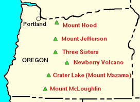 Location relative to other Oregon volcanoes
| |
| Location | Clackamas / Hood River counties, Oregon, U.S. |
| Parent range | Cascade Range |
| Topo map | USGS Mount Hood South |
| Geology | |
| Age of rock | More than 500,000 years[3] |
| Mountain type | Stratovolcano |
| Volcanic arc | Cascade Volcanic Arc |
| Last eruption | 21 September 1865 to January 1866[4] |
| Climbing | |
| First ascent | July 11, 1857, by Henry Pittock, W. Lymen Chittenden, Wilbur Cornell, and the Rev. T. A. Wood[5] |
| Easiest route | Rock and glacier climb |
Mount Hood is an active stratovolcano in the Cascade Volcanic Arc. It was formed by a subduction zone on the Pacific coast and rests in the Pacific Northwest region of the United States. It is located about 50 mi (80 km) east-southeast of Portland, on the border between Clackamas and Hood River counties. In addition to being Oregon's highest mountain, it is one of the loftiest mountains in the nation based on its prominence, and it offers the only year-round lift-served skiing in North America.
The height assigned to Mount Hood's snow-covered peak has varied over its history. Modern sources point to three different heights: 11,249 ft (3,429 m), a 1991 adjustment of a 1986 measurement by the U.S. National Geodetic Survey (NGS),[1] 11,240 ft (3,426 m) based on a 1993 scientific expedition,[6] and 11,239 ft (3,425.6 m)[7] of slightly older origin. The peak is home to 12 named glaciers and snowfields. It is the highest point in Oregon and the fourth highest in the Cascade Range.[8] Mount Hood is considered the Oregon volcano most likely to erupt,[9] though based on its history, an explosive eruption is unlikely. Still, the odds of an eruption in the next 30 years are estimated at between 3 and 7%, so the U.S. Geological Survey (USGS) characterizes it as "potentially active", but the mountain is informally considered dormant.[10]
- ^ a b c "Mount Hood Highest Point". NGS Data Sheet. National Geodetic Survey, National Oceanic and Atmospheric Administration, United States Department of Commerce. Retrieved 2008-03-31.
- ^ "Mount Hood, Oregon". Peakbagger.com. Retrieved 2011-06-04.
- ^ "Mount Hood–History and Hazards of Oregon's Most Recently Active Volcano". U.S. Geological Survey Fact Sheet 060-00. U.S. Geological Survey and U.S. Forest Service. 2005-06-13. Archived from the original on 2018-08-22. Retrieved 2007-01-16.
- ^ "Hood". Global Volcanism Program. Smithsonian Institution. Retrieved 2009-06-01.
- ^ "Glaciers of Oregon". Glaciers of the American West. Archived from the original on 2010-10-03. Retrieved 2007-02-24. quoting McNeil, Fred H. (1937). Wy'east the Mountain, A Chronicle of Mount Hood. Hillsboro, Oregon: Metropolitan Press. OCLC 191334118.
- ^ Cite error: The named reference
Registerwas invoked but never defined (see the help page). - ^ Cite error: The named reference
Traffordwas invoked but never defined (see the help page). - ^ Swanson, D.A.; et al. (1989). "Mount Hood, Oregon". Cenozoic Volcanism in the Cascade Range and Columbia Plateau, Southern Washington and Northernmost Oregon: AGU Field Trip Guidebook T106, July 3–8, 1989. U.S. Geological Survey. Archived from the original on 1999-02-03. Retrieved 2013-07-18.
- ^ Most likely to erupt based on history; see James S. Aber. "Volcanism of the Cascade Mountains". GO 326/ES 767. Emporia State University. Archived from the original on 2011-09-27. Retrieved 2007-07-11.
- ^ Scott, W.E.; Pierson, T.C.; Schilling, S.P.; Costa, J.E.; Gardner, C.A.; Vallance, J.W.; Major, J.J. (1997). "Volcano Hazards in the Mount Hood Region, Oregon". Open-File Report 97-89. U.S. Geological Survey, Cascades Volcano Observatory. Archived from the original on 2008-12-02.