 Global Information
Moonee Ponds Creek information

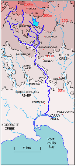
The Moonee Ponds Creek is a creek and major tributary of the Yarra River running through urban Melbourne, Victoria, Australia from northern to inner suburbs. In 2004 a reporter for The Age described it as "arguably the most abused tributary of the Yarra River, and part of the true underside of Melbourne".[1]
It is rural in its upper sections near Greenvale, passing across basalt plains around Woodlands Historic Park,[2] just north of Melbourne Airport. Towards its mouth it is hemmed in by the Cenozoic caps of Essendon and Royal Park before joining the Yarra River.
Through the heavily urbanised areas it flows through it is best characterised as a concrete stormwater drain.
It winds its way through the suburbs of Westmeadows, Meadow Heights, Tullamarine, Broadmeadows, Gowanbrae, Glenroy, Strathmore Heights, Oak Park, Strathmore, Pascoe Vale, Pascoe Vale South, Essendon, Brunswick West, Moonee Ponds, Ascot Vale, Flemington, Parkville, North Melbourne (where its artificially widened section is named Railway Canal) before joining the Yarra River at Melbourne Docklands.
- ^ Margaret Simons (January 18, 2004). "City creek continues its fight for survival". The Age. Retrieved 20 March 2011.
- ^ parkweb.vic.gov.au - Woodlands Historic Park