 Global Information
Yarra River information
| Yarra | |
|---|---|
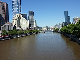 The Yarra River in Melbourne CBD, November 2010 | |
 Yarra River watershed (Interactive map) | |
 Location of the mouth of the Yarra River in Victoria | |
| Etymology | Bunwurrung (Aboriginal Australian languages): Yarro-yarro, "ever-flowing"[1][2] |
| Nickname(s) | The Yarra |
| Native name | Birrarung (Kulin languages) |
| Location | |
| Country | Australia |
| State | Victoria |
| Region | South Eastern Highlands (IBRA), Central Victoria |
| LGA | City of Hobsons Bay City of Port Phillip City of Melbourne City of Yarra City of Darebin City of Boroondara City of Banyule City of Manningham Shire of Nillumbik Yarra Ranges Shire |
| City | Melbourne |
| Physical characteristics | |
| Source | Yarra Ranges, Great Dividing Range |
| • location | within Yarra Ranges National Park |
| • coordinates | 37°44′57″S 146°8′26″E / 37.74917°S 146.14056°E |
| • elevation | 792 m (2,598 ft) |
| Mouth | Hobsons Bay, Port Phillip |
• location | near the suburb of Port Melbourne |
• coordinates | 37°51′7″S 144°54′30″E / 37.85194°S 144.90833°E |
• elevation | 0 m (0 ft) |
| Length | 242 km (150 mi) |
| Basin size | 5,464.4 km2 (2,109.8 sq mi)[3] |
| Discharge | |
| • location | Near mouth |
| • average | 63.5 m3/s (2,000 GL/a)[3] |
| Basin features | |
| River system | Port Phillip catchment |
| Tributaries | |
| • left | Maribyrnong River, Moonee Ponds Creek, Merri Creek, Darebin Creek, Plenty River, Diamond Creek, Steeles Creek, Watts River, Badger Creek, Don River, Cement Creek, O'Shannassy River |
| • right | Gardiners Creek, Glass Creek, Koonung Creek, Mullum Mullum Creek, Andersons Creek, Jumping Creek, Olinda Creek, Woori Yallock Creek, Hoddles Creek, Little Yarra River, Starvation Creek |
| National park | Yarra Ranges NP, Royal Botanic Gardens |
| [4][5] | |

The Yarra River or historically, the Yarra Yarra River,[4] (Kulin languages: Berrern, Birr-arrung, Bay-ray-rung, Birarang,[6] Birrarung,[7] and Wongete[1]) is a perennial river[4] in south-central Victoria, Australia.
The lower stretches of the Yarra are where Victoria's state capital Melbourne was established in 1835, and today metropolitan Greater Melbourne dominates and influences the landscape of its lower reaches. From its source in the Yarra Ranges, it flows 242 kilometres (150 mi) west through the Yarra Valley which opens out into plains as it winds its way through Greater Melbourne before emptying into Hobsons Bay in northernmost Port Phillip Bay.
The river has been a major food source and meeting place for Indigenous Australians for thousands of years. Shortly after the arrival of European settlers, land clearing forced the remaining Wurundjeri people into neighbouring territories and away from the river. Originally called Birrarung by the Wurundjeri, the current name was mistranslated from another Wurundjeri term in the Boonwurrung language; Yarro-yarro, meaning "ever-flowing".[1][2]
The river was utilised primarily for agriculture by early European settlers. The landscape of the river has changed dramatically since 1835. The course has been progressively disrupted and the river widened in places. The first of many crossings of the Yarra River to facilitate transport was built in Princes Bridge. Beginning with the Victorian gold rush it was extensively mined, creating the Pound Bend Tunnel in Warrandyte, and the Big and Little Peninsula Tunnels above Warburton. Widening and dams, like the Upper Yarra Reservoir have helped protect Melbourne from major flooding. The catchment's upper reaches are also affected by logging. Industrialisation ultimately led to the destruction of the marshlands at the confluence of the Yarra and Maribyrnong Rivers in the area around Coode Island in West Melbourne.
Today, the Yarra mouth including Swanson and Appleton docks are used for container shipping by the Port of Melbourne, which is the busiest on the continent. The city reach which is inaccessible to larger watercrafts, has seen increased use for both transport and recreational boating (including kayaking, canoeing, rowing and swimming). In March 2019, it was reported that the river's environmental health is at risk due to litter, pollution, pets and urban development.[8]
The annual Moomba festival celebrates the Yarra River's increasing cultural significance to Melbourne. Melbourne Water is the lead agency for implementing the Yarra Strategic Plan (Burndap Birrarung Burndap Unmarkoo) 2022-32. The plan gives effect to the community's long-term vision for the Yarra and supports collaborative management of the river and its lands.[9]
- ^ a b c "Yarra River: 30146: Historical Information". Vicnames. Government of Victoria. 2 May 1966. Archived from the original on 8 March 2014. Retrieved 8 March 2014.
- ^ a b Cite error: The named reference
reedwas invoked but never defined (see the help page). - ^ a b "East Coastal Watersheds".
- ^ a b c "Yarra River: 30146". Vicnames. Government of Victoria. 2 May 1966. Archived from the original on 8 March 2014. Retrieved 8 March 2014.
- ^ "Map of Yarra River, VIC". Bonzle Digital Atlas of Australia. Retrieved 8 March 2014.
- ^ "BYGONE DAYS". The Argus. Melbourne: National Library of Australia. 15 July 1939. p. 13. Retrieved 25 January 2012.
- ^ Eidelson, Meyer (1997). The Melbourne Dreaming. A Guide to the Aboriginal Places of Melbourne (Reprint 2000 ed.). Canberra: Aboriginal Studies Press. pp. 14–17. ISBN 0-85575-306-4.
- ^ Dunstan, Joseph (20 March 2019). "In four years, 179 tonnes of garbage was pulled out of the Yarra". ABC News. Retrieved 16 May 2022.
- ^ "Yarra Strategic Plan (Burndap Birrarung burndap umarkoo) | Melbourne Water". www.melbournewater.com.au. 11 February 2022. Retrieved 16 May 2022.