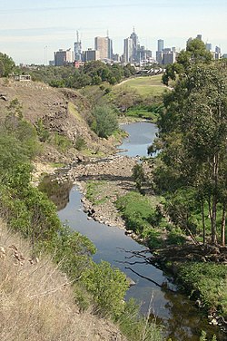
The Merri Creek passing through Fairfield and Clifton Hill with Melbourne city skyline in the distance.
Location
Country
Australia
State
Victoria
Physical characteristics
Length
70 km (43 mi)
Basin size
Unknown
37°45′35″S144°58′53″E / 37.759756°S 144.981482°E / -37.759756; 144.981482
The Merri Creek is a waterway in southern parts of Victoria, Australia which flows through the northern suburbs of Melbourne. It begins near Wallan and flows south for 70 km until joining the Yarra River at Dights Falls. The area where the creek meets the river was traditionally the location for large gatherings of the Wurundjeri people and is suspected to have been the location for one of the earliest land treaties in Australia between Indigenous Australians and European settlers.
The creek was the site of heavy industrial use throughout much of the 20th century, being home to quarries, landfills and accepting waste runoff from neighbouring factories. This has degraded the riparian ecology of the creek leaving behind pollutants such as heavy metals and various greases. Recent decades have seen some regenerative planting and the foundation of several community groups dedicated to protecting and regenerating the creek's ecology.
144°58′53″E / 37.759756°S 144.981482°E / -37.759756; 144.981482 The MerriCreek is a waterway in southern parts of Victoria, Australia which flows through...
/ -37.76839; 144.98405 The MerriCreek Trail is a shared use path for cyclists and pedestrians that follows the MerriCreek through the northern suburbs...
to the MerriCreek, and is connected to Westgarth by a narrow, 80-metre-long footbridge for pedestrians and cyclists, crossing the MerriCreek as part...
consists of sections of other trails, such as the MerriCreek Trail, Main Yarra Trail, Moonee Ponds Creek Trail and Inner Circle Rail Trail. A popular starting...
Isabel; Christiansen, Peter (2001). People of the MerriMerri. The Wurundjeri in Colonial Days. MerriCreek Management Committee. ISBN 978-0-9577728-0-9....
Trail uses the same path up to Dights Falls, where it continues up the MerriCreek Trail as part of its loop around the city. The path starts just to the...
Maribyrnong River, Moonee Ponds Creek, MerriCreek, Darebin Creek, Plenty River, Mullum Mullum Creek and Olinda Creek. The river hosts many geographical...
Toby (2004). A Bend in the Yarra: A History of the MerriCreek Protectorate Station and MerriCreek Aboriginal School 1841–1851. Aboriginal Studies Press...
Merlynston Creek is a tributary of MerriCreek in Melbourne's northern suburbs, in Victoria, Australia. The source of the creek is the National Boulevard...
to Clifton Hill in the south, with MerriCreek providing the vast majority of the western boundary and Darebin Creek, parts of Macleod and Plenty Road...
Ellender and Peter Christiansen, People of the MerriMerri. The Wurundjeri in Colonial Days, MerriCreek Management Committee, 2001 ISBN 0-9577728-0-7...
reaches Merri Parade, where it narrows to a four-lane, single-carriageway road, sharing surface tram tracks. Running south-west, it crosses MerriCreek through...
are the Plenty River, MerriCreek, Darebin Creek, Diamond Creek, Gardiners Creek, Mullum Mullum Creek and the Moonee Ponds Creek. It hosts a wide range...
ISBN 978-1-921862-13-7. "A Bend in the Yarra: A history of the MerriCreek Protectorate Station and MerriCreek Aboriginal School 1841–1851 | AIATSIS". aiatsis.gov...
Isabel; Christiansen, Peter (2001). People of the MerriMerri. The Wurundjeri in Colonial Days. MerriCreek Management Committee. ISBN 978-0-9577728-0-9....
River in Melbourne, Victoria, just downstream of the junction with the MerriCreek. At this point the river narrows and is constricted between 800,000-year-old...
Ellender and Peter Christiansen, People of the MerriMerri. The Wurundjeri in Colonial Days, MerriCreek Management Committee, 2001 ISBN 0-9577728-0-7...
 Global Information