 Global Information
Meghalaya information
This article needs additional citations for verification. (July 2023) |
Meghalaya | |
|---|---|
State | |
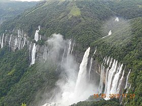  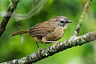  Clockwise from top: Nohkalikai Falls, Tawny Breasted Wren, Umngot River, Khrangsuri waterfalls | |
 Emblem of Meghalaya | |
| Etymology: Abode of the clouds | |
| Motto: Satyameva Jayate (Truth alone triumphs) | |
 Location of Meghalaya in India | |
| Coordinates: 25°34′N 91°53′E / 25.57°N 91.88°E | |
| Country | |
| Region | Northeast India |
| Before was | Part of Assam |
| Formation | 21 January 1972 |
| Capital and largest city | Shillong |
| Districts | 12 |
| Government | |
| • Body | Government of Meghalaya |
| • Governor | Phagu Chauhan[1] |
| • Chief minister | Conrad Sangma (NPP) |
| State Legislature | Unicameral |
| • Assembly | Meghalaya Legislative Assembly (60 seats) |
| National Parliament | Parliament of India |
| • Rajya Sabha | 1 seat |
| • Lok Sabha | 2 seats |
| High Court | Meghalaya High Court |
| Area | |
| • Total | 22,429 km2 (8,660 sq mi) |
| • Rank | 24th |
| Dimensions | |
| • Length | 300 km (200 mi) |
| • Width | 100 km (60 mi) |
| Elevation | 900 m (3,000 ft) |
| Highest elevation (Lushai Hills section) | 1,965 m (6,447 ft) |
| Lowest elevation | 150 m (490 ft) |
| Population (2011)[2] | |
| • Total | |
| • Rank | 22nd |
| • Density | 130/km2 (300/sq mi) |
| • Urban | 20.07% |
| • Rural | 79.93% |
| Demonym | Meghalayans |
| Language | |
| • Official | English[3] |
| • Official script | Latin script |
| GDP | |
| • Total (2023-24) | |
| • Rank | 27th |
| • Per capita | |
| Time zone | UTC+05:30 (IST) |
| ISO 3166 code | IN-ML |
| Vehicle registration | ML |
| HDI (2022) | |
| Literacy (2011) | |
| Sex ratio (2011) | 989♀/1000 ♂ (3rd) |
| Website | meghalaya |
| Symbols of Meghalaya | |
 Emblem of Meghalaya | |
| Bird | Hill myna |
| Flower | Lady's Slipper Orchid |
| Mammal | Clouded leopard |
| Tree | Gamhar |
| State highway mark | |
 | |
| State highway of Meghalaya | |
| List of Indian state symbols | |
Meghalaya (/ˌmeɪɡəˈleɪə/,[5] or /meɪˈɡɑːləjə/,[6] lit. "the abode of clouds"[7]) is a state in northeast India. Meghalaya was formed on 21 January 1972 by carving out two districts from the state of Assam: (a) the United Khasi Hills and Jaintia Hills and (b) the Garo Hills.[8] The estimated population of Meghalaya in 2014 was 3,211,474.[9] Meghalaya covers an area of approximately 22,429 square kilometres, with a length-to-breadth ratio of about 3:1.[10]
The state is bound to the south by the Bangladeshi divisions of Mymensingh and Sylhet, to the west by the Bangladeshi division of Rangpur, and to the north and east by India's State of Assam. The capital of Meghalaya is Shillong. During the British rule of India, the British imperial authorities nicknamed it the "Scotland of the East".[11] English is the official language of Meghalaya. Unlike many Indian states, Meghalaya has historically followed a matrilineal system where the lineage and inheritance are traced through women; the youngest daughter inherits all wealth and she also takes care of her parents.[11]
The state is the wettest region of India, with the wettest areas in the southern Khasi Hills recording an average of 12,000 mm (470 in) of rain a year.[10] About 70 per cent of the state is forested.[12] The Meghalaya subtropical forests ecoregion encompasses the state; its mountain forests are distinct from the lowland tropical forests to the north and south. The forests are notable for their biodiversity of mammals, birds, and plants.
Meghalaya has predominantly an agrarian economy with a significant commercial forestry industry. The important crops are potatoes, rice, maize, pineapples, bananas, papayas, and spices. The service sector is made up of real estate and insurance companies. Meghalaya's gross state domestic product for 2012 was estimated at ₹16,173 crore (US$2.0 billion) in current prices.[13] The state is geologically rich in minerals, but it has no significant industries.[11] The state has about 1,170 km (730 mi) of national highways. It is also a major logistical center for trade with Bangladesh.[10]
In July 2018, the International Commission on Stratigraphy divided the Holocene epoch into three,[14][15] with the late Holocene being called the Meghalayan stage/age,[16][17] since a speleothem in Mawmluh cave indicating a dramatic worldwide climate event around 2250 BCE had been chosen as the boundary stratotype.[18]
One of the biggest Central Institutes, the North Eastern Council Secretariat, is also situated in Shillong.
- ^ "Phagu Chauhan sworn in as Meghalaya governor". The Economic Times. PTI. 18 February 2023. Archived from the original on 13 March 2023. Retrieved 13 March 2023.
- ^ "List of states with Population, Sex Ratio and Literacy Census 2011". Census2011.co.in. Archived from the original on 14 February 2014. Retrieved 9 November 2012.
- ^ "Report of the Commissioner for linguistic minorities: 47th report (July 2008 to June 2010)" (PDF). Commissioner for Linguistic Minorities, Ministry of Minority Affairs, Government of India. pp. 84–89. Archived from the original (PDF) on 13 May 2012. Retrieved 16 February 2012.
- ^ "Sub-national HDI – Area Database". Global Data Lab. Institute for Management Research, Radboud University. Archived from the original on 23 September 2018. Retrieved 25 September 2018.
- ^ "Meghalaya". Merriam-Webster.com Dictionary.
- ^ "Definition of Meghalaya in English from the Oxford Dictionaries". Oxford Dictionaries. Archived from the original on 2 April 2015. Retrieved 1 April 2015.
- ^ Cite error: The named reference
Etymologywas invoked but never defined (see the help page). - ^ History of Meghalaya State Archived 24 September 2013 at the Wayback Machine Government of India
- ^ "Fact sheet on meghalaya" (PDF). 10 March 2014. Archived (PDF) from the original on 4 March 2016. Retrieved 12 September 2014.
- ^ a b c Meghalaya Archived 3 September 2013 at the Wayback Machine IBEF, India (2013)
- ^ a b c Arnold P. Kaminsky and Roger D. Long (2011), India Today: An Encyclopedia of Life in the Republic, ISBN 978-0313374623, pp. 455–459
- ^ Meghalaya and Its Forests Archived 22 August 2014 at the Wayback Machine Government of Meghalaya (2012); Quote – total forest area is 69.5%
- ^ Cite error: The named reference
pcindiawas invoked but never defined (see the help page). - ^ "Collapse of civilizations worldwide defines youngest unit of the Geologic Time Scale". Archived from the original on 18 July 2018. Retrieved 18 July 2018.
- ^ "Meghalaya ecstatic after being etched in geological history permanently". 19 July 2018. Archived from the original on 19 July 2018. Retrieved 21 July 2018.
- ^ Amos, Jonathan (18 July 2018). "Welcome to the Meghalayan Age a new phase in history". BBC News. Archived from the original on 18 July 2018. Retrieved 18 July 2018.
- ^ "Newest phase in Earth's history named after Meghalaya rock". The Times of India. 19 July 2018. Archived from the original on 2 August 2018. Retrieved 19 July 2018.
- ^ "Formal subdivision of the Holocene Series/Epoch" (PDF). Archived from the original (PDF) on 10 July 2018. Retrieved 10 July 2018.