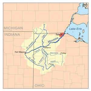
Fort Wayne by the confluence of the St. Joseph and St. Marys
• coordinates
41°04′58″N85°07′56″W / 41.0827778°N 85.1322222°W / 41.0827778; -85.1322222 (Maumee River origin)
• elevation
750 ft (230 m)
Mouth
• location
Lake Erie at Toledo
• coordinates
41°41′58″N83°27′36″W / 41.6994444°N 83.46°W / 41.6994444; -83.46 (Maumee River mouth)
• elevation
571 ft (174 m)
Length
137 miles (220 km)
Basin size
6,354 sq mi (16,460 km2)
Discharge
• average
5,297 cu ft/s (150.0 m3/s)
Basin features
Progression
Northeast
Map all coordinates using OpenStreetMap
Download coordinates as:
KML
GPX (all coordinates)
GPX (primary coordinates)
GPX (secondary coordinates)
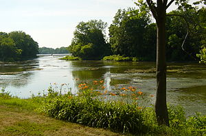
The Maumee River (pronounced /mɔːˈmiː/)[1] (Shawnee: Hotaawathiipi;[2] Miami-Illinois: Taawaawa siipiiwi)[3] is a river running in the United States Midwest from northeastern Indiana into northwestern Ohio and Lake Erie. It is formed at the confluence of the St. Joseph and St. Marys rivers, where Fort Wayne, Indiana has developed, and meanders northeastwardly for 137 miles (220 km)[4] through an agricultural region of glacial moraines before flowing into the Maumee Bay of Lake Erie. The city of Toledo is located at the mouth of the Maumee. The Maumee was designated an Ohio State Scenic River on July 18, 1974. The Maumee watershed is Ohio's breadbasket; it is two-thirds farmland, mostly corn and soybeans. It is the largest watershed of any of the rivers feeding the Great Lakes,[5] and supplies five percent of Lake Erie's water.[6]
^"Maumee – Definition and More from the Free Merriam-Webster Dictionary". Merriam-webster.com. Retrieved November 1, 2012.
^"Shawnees Webpage". Shawnee's Reservation. 1997. Archived from the original on 2013-05-02. Retrieved 2013-04-26.
^"Myaamiaatawaakani | Myaamia Dictionary". Archived from the original on 2017-08-30. Retrieved 2017-04-22.
^U.S. Geological Survey. National Hydrography Dataset high-resolution flowline data. The National Map Archived 2012-03-29 at the Wayback Machine, accessed May 19, 2011
^Cite error: The named reference epa was invoked but never defined (see the help page).
^Cite error: The named reference Wines was invoked but never defined (see the help page).
(secondary coordinates) The MaumeeRiver (pronounced /mɔːˈmiː/) (Shawnee: Hotaawathiipi; Miami-Illinois: Taawaawa siipiiwi) is a river running in the United...
actually a combination of four canals: the Miami and Erie Canal from the MaumeeRiver near Toledo, Ohio, to Junction, Ohio, the original Wabash and Erie Canal...
contact with the headwaters of the MaumeeRiver. Once this happened, the flood waters rushed to the east into the MaumeeRiver, and their erosive force was...
The Auglaize River (Shawnee: Kathinakithiipi) is a 113-mile-long (182 km) tributary of the MaumeeRiver in northwestern Ohio in the United States. It drains...
(″Bean River″), Saint Marys (Nameewa Siipiiwi/Mameewa Siipiiwi) (″River of the Atlantic sturgeon″) and MaumeeRiver (Taawaawa Siipiiwi) (″River of the...
Elkhart, Mishawaka and Goshen. The smallest watershed in the state is the MaumeeRiver watershed in the northeast part of the state on the border with Ohio...
over what is now known as the Toledo Strip. Control of the mouth of the MaumeeRiver and the inland shipping opportunities it represented, and the good farmland...
County MaumeeRiver, a river in northwestern Ohio and northeastern Indiana, United States Maumee Bay, Ohio, on Lake Erie Maumee State Forest, Ohio Maumee Bight...
the territory of the MaumeeRiver. Bands of Odawa-occupied areas known as Roche de Boeuf, and Wolf Rapids on the upper MaumeeRiver. In 1817, in the first...
trees toppled by a tornado near the MaumeeRiver in northwestern Ohio at the site of the present-day city of Maumee, Ohio. Major General "Mad Anthony"...
surrounding wetlands form most of the MaumeeRiver basin, and in 1975 part of the area was incorporated into Maumee Bay State Park. The park is not huge...
and ending at Lake Michigan. The MaumeeRiver in the northeast is formed by the St. Mary's River and the St. Joseph River, which join in Fort Wayne before...
The Sandusky River, like the MaumeeRiver to the west, is home to the annual walleye run in the spring, specifically March–April. The river also receives...
Miami River may refer to: Great Miami River, a tributary of the Ohio River Little Miami River, a tributary of the Ohio RiverMaumeeRiver, referred to...
along the River Raisin. Lieutenant Colonel William Lewis led these men across the frozen MaumeeRiver and along the shore of Lake Erie to the River Raisin...
The Maumee Torrent, also known as the Maumee Megaflood, was a catastrophic draining of Lake Maumee, the ancestor of present-day Lake Erie, that occurred...
rivers in Indiana (U.S. state). MaumeeRiver St. Marys River St. Joseph River Cedar Creek Little Cedar Creek Willow Creek Fish Creek St. Joseph River...
after General Anthony Wayne. It is a suspension bridge that spans the MaumeeRiver. The bridge has some features that give it a unique aesthetic quality...
acquiring supplies. After a methodical campaign up the Great Miami and Maumeeriver valleys in western Ohio Country, Wayne led his Legion to a decisive victory...
 Global Information