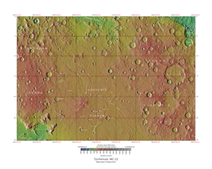
Map of Mare Tyrrhenum quadrangle from Mars Orbiter Laser Altimeter (MOLA) data. The highest elevations are red and the lowest are blue.
Coordinates
15°00′S247°30′W / 15°S 247.5°W / -15; -247.5
Image of Mare Tyrrhenum quadrangle (MC-22). Most of the region contains heavily cratered highlands. The central part contains Tyrrhena Patera and the associated ridged plains of Hesperia Planum.
The Mare Tyrrhenum quadrangle is one of a series of 30 quadrangle maps of Mars used by the United States Geological Survey (USGS) Astrogeology Research Program. This quadrangle is also referred to as MC-22 (Mars Chart-22).[1] It contains parts of the regions Tyrrhena Terra, Hesperia Planum, and Terra Cimmeria.
The Mare Tyrrhenum quadrangle covers the area from 225° to 270° west longitude and 0° to 30° south latitude on Mars. Schiaparelli named the area after Earth's Tyrrhenian Sea, which lies between Italy and Sicily. The region was subsequently renamed to Mare Tyrrhena after spacecraft photos revealed that it is an old, cratered plain rather than a sea. It contains the large volcano Tyrrhenus Mons, one of the oldest, and perhaps the most complex volcanoes on Mars.[2][3] Mare Tyrrhenum's largest crater is Herschel. Licus Vallis and the Ausonia Montes are other major features in the region.
^Davies, M.E.; Batson, R.M.; Wu, S.S.C. “Geodesy and Cartography” in Kieffer, H.H.; Jakosky, B.M.; Snyder, C.W.; Matthews, M.S., Eds. Mars. University of Arizona Press: Tucson, 1992.
^Hartmann, W. 2003. A Traveler's Guide to Mars. Workman Publishing. NY NY.
^Carr, M. 2007. The surface of Mars. Cambridge University Press. New York. ISBN 978-0-521-87201-0
and 23 Related for: Mare Tyrrhenum quadrangle information
The MareTyrrhenumquadrangle is one of a series of 30 quadrangle maps of Mars used by the United States Geological Survey (USGS) Astrogeology Research...
formerly Tyrrhena Mons or Tyrrhena Patera, is a large volcano in the MareTyrrhenumquadrangle of Mars, located at 21.36° south latitude and 253.47° west longitude...
/ɔːˈsoʊniə ˈmɒntiːz/ is a mountain (officially mountains) in the MareTyrrhenumquadrangle of Mars, at 25.42° south latitude and 99.04° east longitude. It...
The Mare Australe quadrangle is one of a series of 30 quadrangle maps of Mars used by the United States Geological Survey (USGS) Astrogeology Research...
The Mare Boreum quadrangle is one of a series of 30 quadrangle maps of Mars used by the United States Geological Survey (USGS) Astrogeology Research Program...
named for a classic albedo feature of the planet and is in the MareTyrrhenumquadrangle of Mars. Tyrrhena Terra is typical of the southern Martian terrae...
latitudes 15 N to 75 S and longitudes 170 to 260 W. It lies in the Eridania quadrangle. Terra Cimmeria is one part of the heavily cratered, southern highland...
long. 110°E in the MareTyrrhenumquadrangle (MC-22). A small part of this region in the south is found in the Hellas quadrangle. It has a maximum width...
features were seas, lakes, and swamps and named them accordingly in Latin (mare, lacus, palus etc.). Within a few decades, however, most astronomers came...
The Mare Acidalium quadrangle is one of a series of 30 quadrangle maps of Mars used by the United States Geological Survey (USGS) Astrogeology Research...
Hellas basin. The type area of the Hesperian System is in the MareTyrrhenumquadrangle (MC-22) around 20°S 245°W / 20°S 245°W / -20; -245. The region...
has been divided into thirty cartographic quadrangles by the United States Geological Survey. Each quadrangle is a region covering a specified range of...
 Global Information