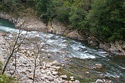
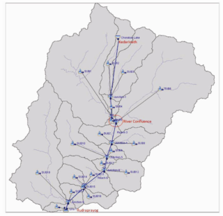
The Mandakini River is a tributary of the Alaknanda River in the Indian state of Uttarakhand.[1] The river runs for approximately 81 kilometres (50 mi) between the Rudraprayag and Sonprayag areas and emerges from the Chorabari Glacier.[2] The Mandakini merges with river Songanga at Sonprayag and flows past the Hindu temple Madhyamaheshwar at Ukhimath.[1] At the end of its course it drains into the Alaknanda, which flows into the Ganges.[1]
The Mandakini is considered by Hindus a sacred river within Uttarakhand as it runs past the Kedarnath and Madhyamaheshwar temples.[3][4] For this reason, the Mandakini has been the site of pilgrimages and religious tourism, with treks passing significant sites of spirituality such as Tungnath and Deoria Tal.[5] The Mandakini area also attracts millions of tourists annually for whitewater rafting, hiking, and religious tours around the winter Chardham being offered. In 2011, more than 25 million tourists visited the river (for comparison, the State of Uttarakhand has a population of about 10 million).[1][3][6] The health of the river and surrounding landforms have slowly been degraded, giving rise to environmental conservation projects such as the Kedarnath Wildlife Sanctuary.[7]
The Mandakini is subject to heavy rainfall, especially during monsoon season. The annual rainfall within the surrounding region is 1,000–2,000 millimetres (39–79 in), which is elevated almost 70% in monsoon season (late July–October).[8] This heavy rainfall is often responsible for rising water levels and intense flash floods.[2] In conjunction with the collapse of a segment of the dammed Chorabari Lake in 2013, an intense patch of heavy rainfall led to the historical devastation of rural villages and death of thousands of locals, pilgrims and tourists.[4] These are known as the 2013 Kedarnath flash floods.
^ abcdRawat, A; Gulati, G; Maithani, R; Sathyakumar, S; Uniyal, VP (20 December 2019). "Bioassessment of Mandakini River with the help of aquatic macroinvertebrates in the vicinity of Kedarnath Wildlife Sanctuary". Applied Water Science. 10 (1): 36. Bibcode:2019ApWS...10...36R. doi:10.1007/s13201-019-1115-5. ISSN 2190-5495.
^ ab"Mandakini River - About Mandakini River of Uttarakhand- Kedarnath flash flood". eUttaranchal. 18 December 2015. Retrieved 6 October 2020.
^ abKala, CP (1 June 2014). "Deluge, disaster and development in Uttarakhand Himalayan region of India: Challenges and lessons for disaster management". International Journal of Disaster Risk Reduction. 8: 143–52. doi:10.1016/j.ijdrr.2014.03.002. ISSN 2212-4209.
^ abBhambri, R; Mehta, M; Dobhal, DP; Gupta, AK; Pratap, B; Kesarwani, K; Verma, A (1 February 2016). "Devastation in the Kedarnath (Mandakini) Valley, Garhwal Himalaya, during 16–17 June 2013: a remote sensing and ground-based assessment". Natural Hazards. 80 (3): 1801–22. doi:10.1007/s11069-015-2033-y. ISSN 1573-0840. S2CID 131701213.
^Bahl & Kapur, R&R. "Kedarnath Flash Floods: Did Anything Change After Five Years?". Youtube. Archived from the original on 19 December 2021.
^Cite error: The named reference :11 was invoked but never defined (see the help page).
^Kansal, ML; Shukla, S; Tyagi, A (30 May 2014). "Probable Role of Anthropogenic Activities in 2013 Flood Disaster in Uttarakhand, India". World Environmental and Water Resources Congress 2014. pp. 924–937. doi:10.1061/9780784413548.095. ISBN 9780784413548.
^Khare, Deepak; Mondal, Arun; Kundu, Sananda; Mishra, Prabhash Kumar (September 2017). "Climate change impact on soil erosion in the Mandakini River Basin, North India". Applied Water Science. 7 (5): 2373–83. Bibcode:2017ApWS....7.2373K. doi:10.1007/s13201-016-0419-y. ISSN 2190-5487.
The MandakiniRiver is a tributary of the Alaknanda River in the Indian state of Uttarakhand. The river runs for approximately 81 kilometres (50 mi) between...
the MandakiniRiver Devprayag, where it meets the Bhagirathi River and officially becomes the Ganges The Alaknanda river is among the best for river rafting...
above sea level near the Chorabari Glacier, which is the source of the Mandakiniriver. The town is flanked by snow-capped peaks, most prominently the Kedarnath...
Panch Prayag (five confluences) of Alaknanda River, the point of confluence of rivers Alaknanda and Mandakini. Kedarnath, a Hindu holy city is located 86 km...
Payaswini and Mandakini, a river in India Mandakini (1999 film), a Sri Lankan film Mandakini (2024 film), an Indian Malayalam film Mandakini (actress) (born...
of the Alakananda river. The Sati Anasuya Ashram is in Chitrakoot, Madhya Pradesh, located further upstream on the MandakiniRiver. It is 16 km away from...
Rudraprayag Town, the district headquarter. Situated on the banks of riverMandakiniRiver, it is a proposed Y-forked railway junction on Chota Char Dham Railway...
Shiva. The temple is located on the Garhwal Himalayan range near the Mandakiniriver, in the state of Uttarakhand, India. Due to extreme weather conditions...
(hidden Kashi) to this place on the bank of the MandakiniRiver. In the upper reaches of the Bhagirathi River, there is another Kashi, called the Uttarkashi...
Kedarnath is located in the MandakiniRiver valley while the other shrines are situated in the highlands between the Mandakini valley and the Alakananda...
married in the small Triyuginarayan village at the confluence of Mandakini and Sone-Ganga rivers. Triyuginarayan is believed to be the capital of Himavat. It...
Chorabari Glacier at the height of 3800 meters and cresting of the MandakiniRiver, which led to heavy floods near Gobindghat, Kedar Dome, Rudraprayag...
Himalayas; the other streams are the Dhauliganga, Nandakini, Pindar, Mandakini and the Bhagirathi - the head stream of the Ganges. Vishnuprayag Nandaprayag...
following is a list of the cities in India through which major rivers flow. "Indian cities located on Rivers" (PDF). Oliveboard. Retrieved 12 September 2020....
Alaka adorned with golden lotuses and sweet tasting water from which Mandakiniriver arises. As per the Mahabharata, the Pandavas, along with their wife...
Tungnath (literal meaning: Lord of the peaks) mountains form the Mandakini and Alaknanda river valleys. It is located at an altitude of 3,680 m (12,073 ft)...
respectively. Chitrakoot Dham is situated on the bank of the Mandakini (Payaswini) river, with mountainous terrain.[citation needed] As of the 2011 census...
Alaka adorned with golden lotuses and sweet tasting water from which Mandakiniriver arises. As per the Mahabharata, the Pandavas along with their wife...
attributed to the Narada-pancharatra, tells how once, while bathing in Mandakiniriver, Parvati becomes sexually aroused, and turns black. At the same time...
formation with a number of glaciers which include the source of the MandakiniRiver. The region has rich flora and fauna, particularly the endangered species...
Augustmuni is a town on the banks of the MandakiniRiver in Rudraprayag district, Uttarakhand, India. It is located 16 kilometers (10 miles) from the...
town of Kedarnath in the Indian state of Uttarakhand, part of the MandakiniRiver system. On 17 June 2013, the moraine holding back the waters of the...
eastern half of the Garhwal region, which lies east of Alaknanda and Mandakiniriver, which was later on known as British Garhwal and Dehradun, along with...
knife or dagger while Mandakini (sometimes spelled Mandangkini or Manjakini) refers to the MandakiniRiver. Thus Cura Si Mandakini is generally accepted...
Indra. In this version, Indra approaches Ahalya on the banks of the Mandakiniriver in his own form to ask for a sexual favour, which is flatly refused...
Hindi-language romantic drama film directed by Raj Kapoor. The film stars Mandakini and Rajiv Kapoor in lead roles. Music director Ravindra Jain received...
The six headstreams are the Alaknanda, Dhauliganga, Nandakini, Pindar, Mandakini and Bhagirathi. Their confluences, known as the Panch Prayag, are all...
 Global Information