 Global Information
List of crossings of the Taunton River information
This is a list of bridges and other crossings of the Taunton River, from its mouth at the Mount Hope Bay upstream to its source at the confluence of the Town River and Matfield River, near the Paper Mill Village neighborhood of the town of Bridgewater, Massachusetts.
This transport-related list is incomplete; you can help by adding missing items. (August 2008) |
| Crossing | Image | Carries | Location | Built | Coordinates |
|---|---|---|---|---|---|
| Charles M. Braga, Jr. Bridge | 
|
Somerset to Fall River | 1966 | 41°42′23.62″N 71°09′56.51″W / 41.7065611°N 71.1656972°W | |
| Slade's Ferry Bridge (demolished 1970) | 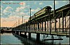
|
originally rail and road traffic | 1875 | 41°43′14.99″N 71°9′31.00″W / 41.7208306°N 71.1586111°W[1] | |
| Brightman Street Bridge (closed to all traffic in 2011) | 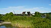
|
formerly carried |
1908 | 41°43′26.26″N 71°09′20.51″W / 41.7239611°N 71.1556972°W | |
| Veterans Memorial Bridge | 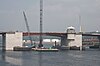
|
2011 | 41°43′35.18″N 71°9′6.24″W / 41.7264389°N 71.1517333°W | ||
| rail bridge (demolished) | 41°46′12″N 71°07′13″W / 41.77000°N 71.12028°W | ||||
| temporary Bailey bridge (removed 2015) | 
|
Elm Street (Berkley) Center Street (Dighton) |
Berkley and Dighton | 2009 | 41°50′05.55″N 71°06′29.71″W / 41.8348750°N 71.1082528°W |
| Berkley–Dighton Bridge | 
|
Elm Street (Berkley) Center Street (Dighton) |
Berkley and Dighton | 2015 | 41°50′05.83″N 71°06′29.28″W / 41.8349528°N 71.1081333°W |
| Berkley-Dighton Bridge (demolished 2010) | Elm Street (Berkley) Center Street (Dighton) |
Berkley and Dighton | 1896 | 41°50′05.83″N 71°06′29.28″W / 41.8349528°N 71.1081333°W | |
| Weir Bridge | 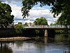
|
Plain Street | Taunton | 1953 | 41°53′09.89″N 71°05′20.62″W / 41.8860806°N 71.0890611°W |
| rail bridge (off Ingell Street, Weir Village) | 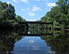
|
Middleboro Subdivision | 41°53′15.29″N 71°05′05.28″W / 41.8875806°N 71.0848000°W | ||
| Edward McCarthy Memorial Bridge | 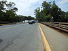
|
1972 | 41°53′48.30″N 71°04′53.76″W / 41.8967500°N 71.0816000°W | ||
| rail bridge (off County Street) | 
|
Massachusetts Coastal Railroad | 41°54′00.65″N 71°04′59.63″W / 41.9001806°N 71.0832306°W | ||
| rail bridge (off Dean Street) | 
|
Massachusetts Coastal Railroad | 41°54′12.85″N 71°04′54.64″W / 41.9035694°N 71.0818444°W | ||
| John Joseph Donahue Memorial Bridge | 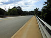
|
Honorable Gordon Owen Riverway | 1975 | 41°54′11.77″N 71°04′32.38″W / 41.9032694°N 71.0756611°W | |
| Harris Street Bridge | 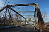
|
closed | 1887 | 41°54′20.12″N 71°04′09.74″W / 41.9055889°N 71.0693722°W | |
| Route 24 bridge | 
|
Raynham | 41°54′06.12″N 71°02′42.90″W / 41.9017000°N 71.0452500°W | ||
| Old Colony Avenue (East Taunton) South Street East (Raynham) |

|
Taunton and Raynham | 1945 | 41°53′09.56″N 71°01′48.07″W / 41.8859889°N 71.0300194°W | |
| Church Street Bridge | 
|
Church Street | Raynham | 1977 | 41°53′37.06″N 71°00′10.54″W / 41.8936278°N 71.0029278°W |
| SFC Jared C. Monti Bridge | Taunton and Raynham | 41°54′11.59″N 70°59′44.88″W / 41.9032194°N 70.9958000°W | |||
| I-495 | Middleborough and Raynham | 41°55′25.00″N 70°59′47.82″W / 41.9236111°N 70.9966167°W 41°55′25″N 70°59′48″W / 41.92361°N 70.996616°W | |||
| World War I Veterans Memorial Bridge (aka Pratts Bridge)[2] | 
|
Vernon Street | Middleborough and Bridgewater | 1956 | 41°55′56.49″N 70°59′35.07″W / 41.9323583°N 70.9930750°W |
| World War II Veterans Memorial Bridge (aka Sturtevant Bridge)[3] | 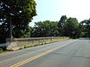
|
Plymouth Street in North Middleboro./ Green Street | 41°56′10.74″N 70°59′14.21″W / 41.9363167°N 70.9872806°W | ||
| Desert Storm Veterans Memorial Bridge | 
|
2007 | 41°56′12.24″N 70°57′56.26″W / 41.9367333°N 70.9656278°W | ||
| Titicut Street Bridge | 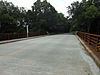
|
Titicut Street | 41°56′02.38″N 70°57′23.47″W / 41.9339944°N 70.9565194°W | ||
| rail bridge | 41°56′20.57″N 70°56′25.69″W / 41.9390472°N 70.9404694°W | ||||
| Vietnam Veterans Memorial Bridge (aka Woodward Bridge) | 
|
Summer Street | 2012 | 41°56′50.99″N 70°56′11.55″W / 41.9474972°N 70.9365417°W | |
| Auburn Street Bridge (ruin) | Auburn Street | 41°57′47.70″N 70°54′44.10″W / 41.9632500°N 70.9122500°W | |||
| Childs Bridge | Cherry Street | Bridgewater and Halifax | 41°58′42.48″N 70°54′43.73″W / 41.9784667°N 70.9121472°W | ||
| Plymouth Street | Bridgewater | 41°59′33.29″N 70°56′23.46″W / 41.9925806°N 70.9398500°W |
River source at the convergence of the Town River and the Matfield River: 41°59′45.09″N 70°56′35.30″W / 41.9958583°N 70.9431389°W
- ^ "USGS via HomeTownLocater". Archived from the original on September 30, 2007. Retrieved August 14, 2007.
- ^ USGS Maps
- ^ USGS Maps