Global Information Lookup Global Information

Libby Dam information


Libby Dam
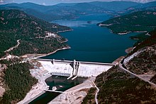
Aerial view from southwest in 1986
Libby Dam is located in Montana
Libby Dam
Location of Libby Dam
Libby Dam is located in the United States
Libby Dam
Libby Dam (the United States)
CountryUnited States
LocationLincoln County, Montana
Coordinates48°24′36″N 115°18′50″W / 48.41°N 115.314°W / 48.41; -115.314
Opening dateAugust 24, 1975
Owner(s)U.S. Army
Corps of Engineers
Dam and spillways
Type of damConcrete gravity
ImpoundsKootenai River
Height422 ft (129 m)
Length3,055 ft (931 m)
SpillwaysGated overflow
Spillway capacity160,000 cu ft/s (4,500 m3/s)
Reservoir
CreatesLake Koocanusa
Total capacity6,027,000 acre⋅ft (7.434 km3)
Catchment area8,985 sq mi (23,270 km2)
Surface area46,700 acres (18,900 ha)
Power Station
Turbines5
Installed capacity600 MW
Annual generation1,574.4 GWh[1]
Website
U.S. Army Corps of Engineers - Libby Dam

Libby Dam is a concrete gravity dam in the northwestern United States, on the Kootenai River in northwestern Montana. Dedicated on August 24, 1975,[2][3][4] it is west of the continental divide, seventeen miles (27 km) upstream from the town of Libby.

At 422 feet (129 m) in height and a length of 3,055 feet (931 m), Libby Dam created Lake Koocanusa, a reservoir which extends ninety miles (140 km) upriver with a maximum depth of about 370 feet (110 m). Forty-two miles (68 km) of it are in Canada in southeastern British Columbia.

Map highlighting major dams and reservoirs in the Kootenai River watershed and surrounds

Lake Koocanusa was named for the treaty that was developed between the Kootenai Indians, the Canadian government, and the U.S. government to build the dam and form the reservoir.[4] It was the fourth dam constructed under the Columbia River Treaty. The Kootenai River is the third largest tributary to the Columbia River, contributing almost twenty percent of the total water in the lower Columbia. Libby Dam has the capacity to hold back 4,980,000 acre-feet (6.14 km3) of water.[5]

The consulting architect for the project was Paul Thiry of Seattle, and the commission for its large granite bas-relief was awarded to sculptor Albert Wein by competition.

In order to make way for the dam, the town of Rexford was relocated and a new Flathead Railroad Tunnel was dug.[4] Construction began in 1966,[6] and the reservoir was available for filling in mid-1973.[4]

The dam is operated by the U.S. Army Corps of Engineers and at full capacity, it can pass over 160,000 cubic feet per second (4,500 m3/s) of water. The dam is designed with a selective withdrawal system that allows water passage from various levels of Lake Koocanusa, which allows the operators to moderate water temperatures downstream.[7] The river continues northwest into Idaho, past Bonners Ferry, to Kootenay Lake in Canada and joins the Columbia River.

Libby Dam's powerhouse contains five turbines and is capable of generating 600 megawatts. The electricity is managed by the Bonneville Power Administration and services eight states: Montana, Idaho, Washington, Wyoming, California, Utah, Oregon, and Nevada. The money earned from electricity sales goes to the United States Treasury to repay the cost of building and operating Libby Dam.[7]

President Gerald Ford was among the five thousand in attendance at the opening in 1975, along with Senator Mike Mansfield, the majority leader, and Governor Thomas Judge.[3] At his first official event after a two-week vacation in Vail, Colorado,[2] Ford "threw the switch" with Donald Macdonald, Canadian minister of energy.[3][4]

  1. ^ "Carbon Monitoring for Action".
  2. ^ a b "Ford heads to Libby (Montana)". Lewiston Morning Tribune. (Idaho). Associated Press. August 24, 1975. p. 2A.
  3. ^ a b c Swigard, Kent (August 25, 1975). "Ford switches on Libby Dam". Spokesman-Review. (Spokane, Washington). p. 1.
  4. ^ a b c d e Floyd, Doug (August 25, 1975). "Dam gets Ford's praise, but it's not energy key". Spokane Daily Chronicle. (Washington). pp. 1, 3.
  5. ^ "Libby Dam and Lake Koocanusa".
  6. ^ Frohnen, Richard (June 20, 1965). "Libby Dam planner on job". Spokesman-Review. (Spokane, Washington). p. 15.
  7. ^ a b "Libby Dam Virtual Tour". US Army Corps of Engineers. Archived from the original on 19 July 2009. Retrieved 14 March 2011.

and 22 Related for: Libby Dam information

Request time (Page generated in 0.8034 seconds.)

Libby Dam

Last Update:

Libby Dam is a concrete gravity dam in the northwestern United States, on the Kootenai River in northwestern Montana. Dedicated on August 24, 1975, it...

Word Count : 569

Lake Koocanusa

Last Update:

and Montana (United States) formed by the damming of the Kootenai River by the Libby Dam in 1972. The Dam was formally dedicated by President Gerald...

Word Count : 789

Kootenay River

Last Update:

Koocanusa is formed by Libby Dam east of Libby, Montana. The Kootenai (as it is now named) receives the Fisher River just downstream of the dam and turns west...

Word Count : 10722

Columbia River Treaty

Last Update:

province of British Columbia (Duncan Dam, Mica Dam, Keenleyside Dam) and one in the U.S. state of Montana (Libby Dam). The treaty provided for the sharing...

Word Count : 6767

Grand Coulee Dam

Last Update:

Canada to construct the Duncan, Keenleyside, Mica Dams upstream and the U.S. would build the Libby Dam in Montana. Shortly afterward, Washington Senator...

Word Count : 8284

Duncan Dam

Last Update:

is 2,400 square kilometers. The dam regulates 10% of the water in the Kootenay River basin. Duncan Dam and Libby Dam together ensure operational water...

Word Count : 241

Kootenay Lake

Last Update:

Dam was constructed above Kootenay Lake on the Duncan River, creating a 7,145 hectare reservoir for flow control. Also part of the treaty Libby Dam in...

Word Count : 1341

List of dams in the Columbia River watershed

Last Update:

March 11, 2016. United States Army Corps of Engineers (May 24, 2013). "Libby Dam Visitor Center hours and tours reduced for Summer 2013". Archived from...

Word Count : 5874

List of tallest dams in the United States

Last Update:

tallest dams in the United States. The main list includes all U.S. dams over 300 feet (91 m) tall, and a second list gives the tallest dams in each state...

Word Count : 423

Rocky Mountain Trench

Last Update:

Trench but exits Canada southwest via Lake Koocanusa reservoir to the Libby Dam. The Kootenay River (Canadian spelling) is a tributary of the Columbia...

Word Count : 3747

Flathead Tunnel

Last Update:

Great Northern Hi-Line that became a necessity due to construction of Libby Dam and subsequent creation of Lake Koocanusa. Work began on May 12, 1966...

Word Count : 579

Corra Linn Dam

Last Update:

River Treaty led to the construction of the flood control Duncan Dam in 1967, and Libby Dam in 1975, which regulated water flowing into Kootenay Lake. Most...

Word Count : 596

Lake Koocanusa Scenic Byway

Last Update:

Koocanusa on Highway 37. The road starts in Libby and proceeds north to Eureka. Lake Koocanusa is formed behind Libby Dam and has a visitors center nearby. The...

Word Count : 139

Bonneville Power Administration

Last Update:

an act of Congress in 1937 to market electric power from the Bonneville Dam located on the Columbia River and to construct facilities necessary to transmit...

Word Count : 1487

List of hydroelectric power stations in the United States

Last Update:

Engineers. "Libby Dam and Lake Koocanusa". Retrieved 2015-01-06. "Electricity Data Browser - Libby". www.eia.gov. Retrieved 2020-02-21. "Little Goose Dam - Hydroelectric...

Word Count : 1807

Mountain whitefish

Last Update:

Community in a Reach of the Kootenai River, Idaho, after Construction of Libby Dam". Journal of Freshwater Ecology. 17 (3): 375–383. doi:10.1080/02705060...

Word Count : 1220

Kootenai National Forest

Last Update:

elsewhere in Montana. Three major hydroelectric dams exist in the Kootenai National Forest. Libby Dam on the Kootenai River creates a 90-mile (140 km)-long...

Word Count : 502

Brilliant Dam

Last Update:

generation of the dam to 265 MW. Brilliant Dam is downstream of Kootenay River's 49 MW Corra Linn Dam, 583 MW Kootenay Canal and 600 MW Libby Dam. Canada portal...

Word Count : 238

List of dams and reservoirs in Montana

Last Update:

Energy Hungry Horse Dam, Hungry Horse Reservoir, USBR Kicking Horse Dam, Kicking Horse Reservoir, Bureau of Indian Affairs Libby Dam, Lake Koocanusa, USACE...

Word Count : 343

List of largest reservoirs in the United States

Last Update:

Online. Retrieved 2012-05-13. "USGS Gage #12301920 on Lake Koocanusa near Libby, MT" (PDF). National Water Information System. U.S. Geological Survey. 1972–2007...

Word Count : 690

Northern Transcon

Last Update:

present-day line at Jennings, located just below the Libby Dam. In 1970, the construction of the Libby Dam formed Lake Koocanusa, flooding the towns of Rexford...

Word Count : 2152

Teck Resources

Last Update:

Retrieved March 8, 2021. "Remarks at Dedication Ceremonies for the Libby Dam, Libby, Montana. | the American Presidency Project". Kelly, Myla; Sullivan...

Word Count : 5308

PDF Search Engine © AllGlobal.net