Global Information Lookup Global Information

Kootenay River information


Kootenay River
Kootenai River
The Kootenai River at Libby, Montana
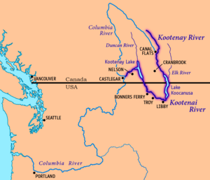
Map of the Kootenay/Kootenai River, its main tributaries and lakes, and major cities.
Native name
  • aqkinmiluk (Kutenai)
  • aqkoktlaqatl (Kutenai)
Location
CountriesCanada, United States
ProvinceBritish Columbia
StatesMontana, Idaho
Physical characteristics
SourceSouth flank of Castle Mountain
 • locationMount Hungabee, Kootenay National Park, British Columbia, Canada
 • coordinates51°18′53.6″N 116°17′10.6″W / 51.314889°N 116.286278°W / 51.314889; -116.286278[1]
 • elevation2,261 m (7,418 ft)[1]
MouthColumbia River
 • location
Castlegar, British Columbia, Canada
 • coordinates
49°19′0″N 117°39′4″W / 49.31667°N 117.65111°W / 49.31667; -117.65111[2]
 • elevation
420 m (1,380 ft)[3]
Length780 km (480 mi)[4]
Basin size50,298 km2 (19,420 sq mi)[3]
Discharge 
 • locationColumbia River at Castlegar, BC (rates given for Kootenay Lake near Corra Linn Dam[5][6] some 10 miles upstream)
 • average782 m3/s (27,600 cu ft/s)[5][6]
 • minimum104 m3/s (3,700 cu ft/s)
 • maximum4,930 m3/s (174,000 cu ft/s)
Basin features
Tributaries 
 • leftPalliser River, White River, Bull River, Elk River, Fisher River, Tobacco River, Lake Creek
 • rightSt. Mary River, Yaak River, Moyie River, Goat River, Duncan River, Slocan River
Map

The Kootenay River[7] or Kootenai River[2] is a major river of the Northwest Plateau in southeastern British Columbia, Canada, and northern Montana and Idaho in the United States. It is one of the uppermost major tributaries of the Columbia River, the largest North American river that empties into the Pacific Ocean. The Kootenay River runs 781 kilometres (485 mi) from its headwaters in the Kootenay Ranges of the Canadian Rockies, flowing from British Columbia's East Kootenay region into northwestern Montana, then west into the northernmost Idaho Panhandle and returning to British Columbia in the West Kootenay region, where it joins the Columbia at Castlegar.

The river is known as the "Kootenay" in Canada and by the Ktunaxa Nation,[7] and as the "Kootenai" in the United States and by the Confederated Salish and Kootenai Tribes and Kootenai Tribe of Idaho.[2] Fed mainly by glaciers and snowmelt, the river drains a rugged, sparsely populated region of more than 50,000 km2 (19,000 sq mi), of which over 70 percent is in Canada. From its headwaters to its confluence with the Columbia River, the Kootenay descends more than 2,000 metres (6,600 ft). At their confluence, the Columbia and Kootenay are similar in length, drainage area, and volume, but less of the Kootenay is impounded in reservoirs and thus it has more free-flowing stretches with rapids and falls. Part of the lower Kootenay forms Kootenay Lake, one of the largest natural lakes in British Columbia.

The Ktunaxa (Kootenai) were the first people to live along the Kootenay River. For hundreds of years, they hunted and fished on the river, quite isolated from neighboring tribes. In the 19th century, Canadian explorer David Thompson became the first recorded European to reach the Kootenay and established trading posts throughout the region. A gold rush followed by silver and galena strikes in the late 19th century drew thousands of miners and settlers to the region, bringing developments such as railroads and steamboat navigation. The Doukhobors, a Russian religious sect, established a short-lived colony, Brilliant, at the Kootenay's mouth; subsequently dispersing into many settlements, they contributed to the region's timber and agricultural industries.

As with many Pacific Northwest rivers, many dams were built on the Kootenay in the 20th century to generate electricity and protect against floods and droughts. Water levels of Kootenay Lake are artificially regulated, and numerous hydroelectric dams block the river between Kootenay Lake and the Columbia River. Upstream of Kootenay Lake, most of the river is free-flowing with the exception of the Libby Dam in Montana, which forms Lake Koocanusa.

  1. ^ a b Source elevations and coordinates derived from Google Earth using data from Canadian topo maps
  2. ^ a b c U.S. Geological Survey Geographic Names Information System: Kootenai River
  3. ^ a b "The Rivers - Stories". Balance of Power. 2007. Archived from the original on November 6, 2011. Retrieved September 3, 2008.
  4. ^ Cite error: The named reference overview was invoked but never defined (see the help page).
  5. ^ a b "Kootenay Lake Outflow Near Corra Linn – Monthly Mean Discharge". HYDAT Archived Hydrometric Data. Environment Canada. 1937–2010. Archived from the original on 2012-04-21. Retrieved 2011-11-25.
  6. ^ a b "Kootenai River Basin - Hydrology". International Alliance for Water Quality and Aquatic Resources. Kootenai River Network, Inc. 2010-03-14. Archived from the original on September 6, 2007. Retrieved 2010-03-25.
  7. ^ a b "Kootenay River". BC Geographical Names. Retrieved 2010-04-13.

and 25 Related for: Kootenay River information

Request time (Page generated in 0.7888 seconds.)

Kootenay River

Last Update:

The Kootenay River or Kootenai River is a major river of the Northwest Plateau in southeastern British Columbia, Canada, and northern Montana and Idaho...

Word Count : 10722

Kootenays

Last Update:

The Kootenays or Kootenay (/ˈkuːtni/ KOOT-nee) is a region of southeastern British Columbia. It takes its name from the Kootenay River, which in turn was...

Word Count : 1014

Kootenay Lake

Last Update:

Kootenay Lake is a lake located in British Columbia, Canada. It is part of the Kootenay River. The lake has been raised by the Corra Linn Dam and has...

Word Count : 1341

Kootenay National Park

Last Update:

including parts of the Kootenay and Park mountain ranges, the Kootenay River and the entirety of the Vermilion River. While the Vermilion River is completely contained...

Word Count : 3799

Kootenay

Last Update:

Kootenay River in British Columbia, Canada Kootenay National Park, a national park in British Columbia at the source of the Kootenay River Kootenay Pass...

Word Count : 401

Columbia River

Last Update:

confluence with the Kootenay River, and Trail, two major population centers of the West Kootenay region. The Pend Oreille River joins the Columbia about...

Word Count : 18450

Columbia and Kootenay Railway

Last Update:

unnavigable Kootenay River, linked Nelson on the west arm of Kootenay Lake with Robson at the confluence of the Kootenay River and the Columbia River near Castlegar...

Word Count : 351

FortisBC

Last Update:

First Nation. FortisBC owns four hydroelectric generating plants on the Kootenay River with a total capacity of 225 megawatts (MW). They are the Corra Linn...

Word Count : 3180

Kootenay Pass

Last Update:

d'Oreille River on the west (via tributaries Stagleap Creek, the South Salmo River and the Salmo River) from that of Kootenay River/Kootenay Lake to the...

Word Count : 296

British Columbia Highway 95

Last Update:

is located. From the Highway 95A junction, Highway 93/95 follows the Kootenay River upstream for 45 km (28 mi), through Skookumchuck to the town of Canal...

Word Count : 684

Steamboats of the upper Columbia and Kootenay Rivers

Last Update:

reaches of the Columbia and Kootenay in the Rocky Mountain Trench, in western North America. The circumstances of the rivers in the area, and the construction...

Word Count : 5729

British Columbia Highway 93

Last Update:

southeastern part of British Columbia, in the Regional District of East Kootenay and takes its number from U.S. Highway 93 that it connects with at the...

Word Count : 645

Rocky Mountain Trench

Last Update:

Rivers that follow the Trench, at least in part, are the Kootenay River, the Columbia River, the Canoe River, the Flathead River, the Fraser River, the...

Word Count : 3747

Kutenai

Last Update:

tun-AH-hah; Kutenai: [ktunʌ́χɑ̝]), Ksanka (/kəˈsɑːnkɑː/ kə-SAHN-kah), Kootenay (in Canada) and Kootenai (in the United States), are an indigenous people...

Word Count : 4344

List of British Columbia Provincial Parks

Last Update:

Central Kootenay Central Okanagan Columbia-Shuswap Comox Valley Cowichan Valley East Kootenay Fraser-Fort George Fraser Valley Kitimat-Stikine Kootenay Boundary...

Word Count : 616

Selkirk Mountains

Last Update:

Purcell Trench, which contains the Beaver River, Duncan River, Duncan Lake, Kootenay Lake and the Kootenay River. The Selkirks are distinct from, and geologically...

Word Count : 952

List of dams in the Columbia River watershed

Last Update:

(Upper Elk Lake) to mouth (Kootenay River, BC). Dams are listed in order from headwater (near Mount Dawson) to mouth (Kootenay River, BC). Dams are listed...

Word Count : 5874

List of tributaries of the Columbia River

Last Update:

(British Columbia, Washington, Idaho; see below for sub-tributaries) Kootenay River (British Columbia, Idaho, Montana; see below for sub-tributaries) Hugh...

Word Count : 1609

Regional District of East Kootenay

Last Update:

Pass and an important coal-mining region. Other than the Columbia and Kootenay Rivers, whose valleys form the bottomlands of the Rocky Mountain Trench, also...

Word Count : 782

Purcell Trench

Last Update:

The Purcell Trench, also known as the Kootenay River Valley is a large valley on the western side of the northern part of North America's Rocky Mountains...

Word Count : 616

Cross River

Last Update:

Cross River may refer to: Cross River (British Columbia), a tributary of the Kootenay River Cross River (Nigeria) Cross River gorilla (Gorilla gorilla...

Word Count : 163

Lake Koocanusa

Last Update:

What was once a barrier to river travel, Jennings Canyon is now inundated by the lake. The Elk River joins the Kootenay River in the northern part of Lake...

Word Count : 789

Goat River

Last Update:

Goat River may refer to: One of three rivers in British Columbia, Canada: Goat River (Kootenay River), a tributary of the Kootenay River, joining it at...

Word Count : 142

Kootenay Ranges

Last Update:

the Kootenay River Beaverfoot Range Hughes Range Stanford Range Vermilion Range "Kootenay Ranges". Bivouac.com. Retrieved 2021-06-28. "Kootenay Ranges"...

Word Count : 120

Kootenay Lake ferry

Last Update:

The Kootenay Lake ferry is a ferry across Kootenay Lake in southeastern British Columbia, which operates between Balfour, on the west side of the lake...

Word Count : 678

PDF Search Engine © AllGlobal.net