Pioneer Creek, Ada River, Toorongo River, Loch River, Hawthorn Creek, Tanjil River, Anderson Creek, Tyers River, Rintoul Creek, Eaglehawk Creek, Thomson River, Avon River
• right
Bennie Creek, Morwell River, Wade Creek, Traralgon Creek, Flynns Creek
National parks
The Lakes NP, Gippsland Lakes CP
[1][5]
The Latrobe River (or sometimes La Trobe[2] or LaTrobe) is a perennial river of the West Gippsland catchment, located in the West Gippsland region of the Australian state of Victoria. The Latrobe River and its associated sub-catchment is an important source for the Gippsland Lakes, draining the south eastern slopes of the Great Dividing Range.
^ ab"Latrobe River: 19128". Vicnames. Government of Victoria. 2 May 1966. Retrieved 25 June 2015.
^ ab"La Trobe River". Gazetteer of Australia online. Geoscience Australia, Australian Government.
^Blake, Les (1977). Place names of Victoria. Adelaide: Rigby. p. 294. ISBN 0-727-00250-3.
^Reed, A. W. (1973). Place names of Australia. Frenchs Forest: Reed Books. p. 135. ISBN 0-589-50128-3.
^"Map of Latrobe River, VIC". Bonzle Digital Atlas of Australia. Retrieved 8 February 2014.
^"Latrobe River: 19128: Traditional Name: Durt'yowan". Vicnames. Government of Victoria. 12 August 2011. Archived from the original on 22 February 2014. Retrieved 25 June 2015.
^"Latrobe River: 19128: Traditional Name: Durt'yowan". Vicnames. Government of Victoria. 12 May 2011. Archived from the original on 22 February 2014. Retrieved 25 June 2015.
^"Latrobe River: 19128: Traditional Name: Tanjil". Vicnames. Government of Victoria. 12 August 2011. Archived from the original on 22 February 2014. Retrieved 25 June 2015.
The LatrobeRiver (or sometimes La Trobe or LaTrobe) is a perennial river of the West Gippsland catchment, located in the West Gippsland region of the...
grandnephew of John H. B. Latrobe Australia City of Latrobe, Victoria LatrobeRiver, West Gippsland, Victoria, Australia Latrobe Valley, Gippsland, Victoria...
Charles Joseph La Trobe CB (20 March 1801 – 4 December 1875), commonly Latrobe, was appointed in 1839 superintendent of the Port Phillip District of New...
in Moe, Churchill and Traralgon. The city is named after the LatrobeRiver and Latrobe Valley, major geographical features that meander through the north...
Benjamin Henry Boneval Latrobe (May 1, 1764 – September 3, 1820) was an Anglo-American neoclassical architect who immigrated to the United States. He...
Hong-Kong-based CLP Group, is located in the Latrobe Valley of Victoria, Australia, beside the LatrobeRiver, with the company town of Yallourn located...
in the east of the Latrobe Valley in the Gippsland region of Victoria, Australia and the most populous city in the City of Latrobe and the region. The...
Benjamin Henry Latrobe II was born in Philadelphia, Pennsylvania on December 19, 1806,: 243 Latrobe was the youngest son of Benjamin Henry Latrobe, who, six...
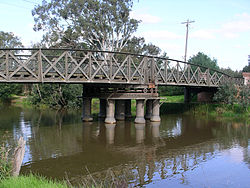
city of Sale, Victoria, Australia and spans the LatrobeRiver at its junction with the Thomson River. The bridge was designed to be operated by a two-person...
Morwell is a town in the Latrobe Valley area of Gippsland, in South-Eastern Victoria, Australia approximately 152 km (94 mi) east of Melbourne. Morwell...
railway line or Bairnsdale railway line) is a railway line serving the Latrobe Valley and Gippsland regions of Victoria, Australia. It runs east from...
Bass Strait (Ninety Mile Beach) to the south. Near the mouth of the LatrobeRiver is the main town Sale, which has a population of about 19,600 (including...
LatrobeRiver, south of Yallourn North. The river descends 156 metres (512 ft) over its 41-kilometre (25 mi) course. The lower reaches of the river has...
stock run in the 1840s at the place where Sheepwash Creek meets the LatrobeRiver, which he called "Loy Yang", an Aboriginal name meaning "Big Eel". Loy...
on the LatrobeRiver built to supply cooling water for the nearby brown coal-fired power stations. Lake Narracan is located on the LatrobeRiver in the...
confluence with the LatrobeRiver west of both Lake Narracan and Yallourn North in the Latrobe City local government area. The river descends 149 metres...
less than 10 cm per year. The lower reaches of the LatrobeRiver, Thomson River and Mitchell River flow into the Gippsland Lakes and have extensive floodplains...
confluence with the LatrobeRiver, near the Mount Baw Baw Road, north of the locality of Neerim North in the Shire of Baw Baw. The river descends 490 metres...
 Global Information