Global Information Lookup Global Information

La Crosse River Trail information


The La Crosse River State Trail is a 22-mile (35 km) rail trail between Sparta and Onalaska, Wisconsin. It is designed for foot, bicycle, equestrian or light motorized traffic. It is designated as a multiuse trail, offering recreational access to the routes, and is open to the public.[1] The trail runs parallel to the La Crosse River.

Map of the La Crosse River Trail and connecting trails

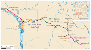
It is one of four connecting bike trails in west-central Wisconsin that spans approximately one-third of the state. The trail is known for the rural scenery and terrain of the Coulee Region. It is part of the larger Wisconsin bike trail system, operated by the state of Wisconsin.

The four connecting west central Wisconsin trails, known as the Bike 4 Trails, going from southeast to northwest are:

  • the 400 State Trail (22 mi or 35 km)
  • the Elroy-Sparta State Trail (32 mi or 51 km)
  • the La Crosse River Trail (22 mi or 35 km)
  • the Great River Trail (24 mi or 39 km)
La Crosse River trail bridge over the CP Railway

The western end of the trail is at the intersection with the Great River Trail at a parking lot off of County Highway B east of La Crosse River Trail WIS 16 in Onalaska (43°51′35″N 91°12′06″W / 43.85972°N 91.20167°W / 43.85972; -91.20167), while the eastern end is at the intersection with the Elroy-Sparta State Trail on John St. in Sparta (43°55′55″N 90°47′50″W / 43.93194°N 90.79722°W / 43.93194; -90.79722).

Sparta/La Crosse trails start/end in Sparta

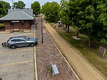
The trail headquarters is located in a historic depot in Sparta and is open from May 1 through October 31. There is a $5.00 per day fee for use of the trail if one does not have the $25.00 yearly Wisconsin bike trail pass. Camping, lodging, food, parking, bike rentals and information are available at many points along the trail.

The trail is constructed upon the abandoned Chicago and North Western Railway railroad bed. It originally was built for the Baraboo Air Line Railroad and the La Crosse, Trempealeau & Presscott Railroad routes from Sparta to Winona, Minnesota. The trail is not paved, but is smooth, and covered with packed crushed limestone.

  1. ^ La Crosse River State Trail - Wisconsin DNR

and 21 Related for: La Crosse River Trail information

Request time (Page generated in 0.8629 seconds.)

La Crosse River Trail

Last Update:

The La Crosse River State Trail is a 22-mile (35 km) rail trail between Sparta and Onalaska, Wisconsin. It is designed for foot, bicycle, equestrian or...

Word Count : 404

La Crosse River

Last Update:

Downstream of Sparta, the river is paralleled by the La Crosse River State Trail. List of Wisconsin rivers "La Crosse River". Geographic Names Information...

Word Count : 256

Great River Trail

Last Update:

(32 mi or 51 km) the La Crosse River Trail (22 mi or 35 km) the Great River State Trail (24 mi or 39 km) The north end of the trail is on Refuge Rd. at...

Word Count : 646

Baraboo Air Line Railroad

Last Update:

Reedsburg to Elroy is now the 400 State Trail. The portion from Sparta through Medary is now the La Crosse River Trail. The Madison, Lodi and Baraboo Railroad...

Word Count : 660

400 State Trail

Last Update:

Elroy-Sparta State Trail (32 mi or 51 km) La Crosse River Trail (22 mi or 35 km) Great River Trail (24 mi or 39 km) The 400 State Trail connects to the Elroy-Sparta...

Word Count : 589

Wisconsin

Last Update:

northern sections of Wisconsin, and sawmills sprang up in cities like La Crosse, Eau Claire, and Wausau. These economic activities had dire environmental...

Word Count : 14828

List of rail trails in the United States

Last Update:

Fox River State Recreational Trail Gandy Dancer Trail Glacial Drumlin State Trail Great River State Trail Hank Aaron State Trail La Crosse River Trail Lake...

Word Count : 3433

Dells of the Wisconsin River

Last Update:

perspective Ice Age Trail Missoula Floods "The Dells of the Wisconsin River" is generally used in the singular. "Dells of the Wisconsin River State Natural...

Word Count : 800

Ice Age Trail

Last Update:

shoreline in the east. The western end of the trail is at Interstate State Park along the St. Croix River, which is the border between northwestern Wisconsin...

Word Count : 1849

Timms Hill

Last Update:

line of sight. The 10-mile (16 km) Timms Hill Trail connects to the Ice Age Trail, a National Scenic Trail stretching 1,200 miles (1,900 km) across glacial...

Word Count : 352

List of bike trails in Wisconsin

Last Update:

(39 km) La Crosse River Trail — 22 miles (35 km) Military Ridge State Trail — Near Dodgeville. Two segments totalling 39.5 miles (63.6 km) Omaha Trail — Railroad...

Word Count : 1003

Apostle Islands National Lakeshore

Last Update:

governor of Wisconsin, who was instrumental in establishing the National Trails System, the Wilderness Act, and Earth Day. The National Park Travelers Club...

Word Count : 1873

Kettle Moraine State Forest

Last Update:

(32 km) of trails, and an observation tower. The Mukwonago River Unit is in Waukesha and Walworth Counties, adjacent to the Mukwonago River. List of Wisconsin...

Word Count : 598

Beerline Trail

Last Update:

Milwaukee County. The railroad formerly occupying the trail area was first built in 1854 by the La Crosse & Milwaukee Railroad Company; by 1858, the railroad...

Word Count : 589

Lac la Plonge

Last Update:

Lac la Plonge is a glacial lake in the Canadian province of Saskatchewan in the basin of the Beaver River, near Lac Île-à-la-Crosse. It is located in...

Word Count : 587

Blue Mound State Park

Last Update:

features a pair of observation towers affording views of the Wisconsin River valley and Baraboo Range to the north, the mounds, buttes, and rolling forests...

Word Count : 510

Powell Marsh Wildlife Area

Last Update:

pickerel family. There is one managed trail in the wildlife area, the 8.5-mile (13.7 km) Powell Marsh Ski Trail. The Ski Trail is managed by the Northern Highland-American...

Word Count : 1945

Aztalan State Park

Last Update:

Historic Places in 1966. The park covers 172 acres (70 ha) along the Crawfish River. Aztalan is the site of an ancient Mississippian culture settlement that...

Word Count : 2574

Durst Rockshelter State Natural Area

Last Update:

Koshkonong Corners Kroenke Lake Krueger Pines Kurtz Woods La Crosse River Trail Prairie LaFave Swamp Lake Alva Birch-Hemlock Lake Evelyn Lake Helane Lake...

Word Count : 160

Avon Bottoms Wildlife Area

Last Update:

to improve and preserve wildlife and habitat diversity along the Sugar River, a popular destination for kayakers, canoers, and tubers. The preservation...

Word Count : 388

List of Wisconsin state parks

Last Update:

List of Wisconsin state forests Loohuis, Jackie (May 6, 2006). "Happy trails, old and new". Milwaukee Journal-Sentinel. Retrieved November 4, 2008. "Wisconsin...

Word Count : 1668

PDF Search Engine © AllGlobal.net