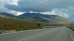
Konispol (Albanian definite form: Konispoli) is the southernmost town in Albania. It sits one kilometer away from the Albanian-Greek border. The settlement is inhabited by Muslim Cham Albanians.[1] Konispol is the modern centre of the Cham Albanian community in Albania. The main economic interests of Konispol are agriculture and viticulture.
The town is the seat of the southernmost administrative unit in Albania, the Municipality of Konispol (Albanian: Bashkia Konispol). It was formed during the 2015 local government reform by the merger of the former municipalities of Konispol, Markat and Xarrë.
[2] The total population is 8,245 (2011 census),[3] in a total area of 226.26 km2.[4] The population of the former Konispol municipality at the 2011 census was 2,123.[3]
The former Konispol municipal unit (pre-2015) consisted of the town Konispol and the village Çiflik.[5] The new larger municipality of Konispol contains settlements that are inhabited by Albanians who form the majority of the population, Aromanians, Greeks and Romani that live in the villages of Xarrë municipal unit.[1][6][7]
^ abCite error: The named reference Kallivretakis was invoked but never defined (see the help page).
^"Law nr. 115/2014" (PDF) (in Albanian). p. 6376. Retrieved 25 February 2022.
^ ab"Population and housing census - Vlorë 2011" (PDF). INSTAT. Retrieved 2019-09-25.
^"Correspondence table LAU – NUTS 2016, EU-28 and EFTA / available Candidate Countries" (XLS). Eurostat. Retrieved 2019-09-25.
^Greece – Albania Neighbourhood Programme Archived March 27, 2012, at the Wayback Machine
^Cite error: The named reference Kretsi197198210 was invoked but never defined (see the help page).
^Cite error: The named reference Baltsiotis2015 was invoked but never defined (see the help page).
Konispol (Albanian definite form: Konispoli) is the southernmost town in Albania. It sits one kilometer away from the Albanian-Greek border. The settlement...
Ioannina (some villages at the western side); and the municipality of Konispol at the southernmost extremity of Albania. As the wider Greek toponyms Epirus...
ethnic Albanian minority in the Epirus region of northwestern Greece and in Konispol, southern Albania. Albanians in the region of Epirus are attested in historical...
same as the Mesolithic population of the southern Balkans like in the Konispol cave where the Mesolithic stratum co-exists with Pre-Pottery Neolithic...
the region formerly inhabited by the Chams, along the Ionian coast from Konispol to the north to the Acheron valley south. This area corresponds to a few...
have been excavated, out of which the most prominent ones are the cave of Konispol (24,700 BC), the flint tools found near Xarrë, the shelters of the Blaz...
family of Filiates which was a Cham Albanian, Muslim family. He was born in Konispol, Albania, on August 25, 1922. His father, Mehmet Sejko, was a landlord...
Army in Konispol.[verification needed] At the end of 1943 the men of this ethnically mixed battalion fought against the Germans in Konispol. They later...
not execute him. After some days he was caught again and was killed in Konispol. Eno Koço (2010). The Vocal Iso(n): The Preservation of Traditions in North...
with a large Christian minority. A Muslim population was also located in Konispol and some villages around the town. The Ottoman administrative sancaks or...
Area rank 9th Length 250 m (820 ft) Width 100 m (300 ft) Highest elevation 10 m (30 ft) Administration Albania County Vlorë County Municipality Konispol...
but it also includes the southernmost part of Albania, the area around Konispol. It is approximately 10,000 square kilometres in size and has a current...
the Regional Committee of the National Anti-fascist Liberation Army in Konispol. The decision was adopted on June 30, 1943, when three resistance groups...
2015 local government reform, it became a subdivision of the municipality Konispol. The population in the 2011 census was 1,859. The municipal unit consists...
19th century. Hasan Tahsini was born in 1811 in the village of Ninat, Konispol, then part of the Ottoman Empire. His father Osman Efendi Rushiti was a...
highway that will connect Igoumenitsa and Saranda, passing by Sagiada and Konispol. The port of Igoumenitsa serves ferry routes to the islands of Corfu and...
 Global Information