 Global Information
Kitling Peak information
| Kitling Peak | |
|---|---|
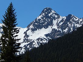 Kitling Peak seen from the North Cascades Highway | |
| Highest point | |
| Elevation | 8,003 ft (2,439 m)[1] |
| Prominence | 523 ft (160 m)[1] |
| Parent peak | Mesahchie Peak (8,795 ft)[2] |
| Isolation | 0.54 mi (0.87 km)[1] |
| Coordinates | 48°34′56″N 120°51′24″W / 48.58222°N 120.85667°W[1] |
| Geography | |
 Kitling Peak Location of Kitling Peak in Washington  Kitling Peak Kitling Peak (the United States) | |
| Country | United States |
| State | Washington |
| County | Skagit |
| Protected area | North Cascades National Park Stephen Mather Wilderness[2] |
| Parent range | North Cascades Cascade Range |
| Topo map | USGS Mount Arriva |
| Climbing | |
| First ascent | August 24, 1968, John Roper, Chris Roper[3] |
| Easiest route | Scrambling |
Kitling Peak is an 8,003-foot (2,439-metre) mountain summit in the North Cascades in the U.S. state of Washington.[1] It is located one mile northwest of Easy Pass on the borders of the Stephen Mather Wilderness and North Cascades National Park. Kitling Peak is situated at the east end of Ragged Ridge. Other peaks on Ragged Ridge include Mesahchie Peak, Kimtah Peak, Katsuk Peak, and Graybeard Peak. The nearest higher peak is Mesahchie Peak, 0.95 miles (1.53 km) to the south.[1] The Mesahchie Glacier on Kitling's northwest slope forms the headwaters of Panther Creek. Precipitation runoff on the east side of the mountain drains into Ross Lake via Granite Creek, whereas the west side of the peak drains into Diablo Lake via Panther Creek and Fisher Creek. Topographic relief is significant as the summit rises 3,000 feet (910 meters) above Fisher Creek in one mile (1.6 km) and the northeast slope rises 3,400 feet (1,000 meters) above Kitling Creek in 0.75 mile (1.2 km). The mountain's name "Kitling" derives from Chinook Jargon "ketling" which means kettle.[4] The mountain takes its name from Kitling Lake which is one mile north of the peak.[5] The toponym was officially adopted in 1969 by the U.S. Board on Geographic Names.[5]
- ^ a b c d e f "Kitling Peak, Washington". Peakbagger.com.
- ^ a b "Kitling Peak WA - 8,003'". Lists of John. Retrieved 2024-04-04.
- ^ Beckey, Fred W. (2009). Cascade Alpine Guide: climbing and high routes, Vol. 3, Rainy Pass to Fraser River (3rd ed.). Mountaineers Books. ISBN 978-1-59485-136-0.
- ^ Dictionary of the Chinook Jargon, George Gibbs, Cramoisy Press, 1863.
- ^ a b "Kitling Peak". Geographic Names Information System. United States Geological Survey, United States Department of the Interior. Retrieved 2020-02-24.