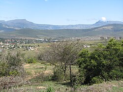
The Keiskamma River (Afrikaans: Keiskammarivier) is a river in the Eastern Cape Province in South Africa. The river flows into the Indian Ocean in the Keiskamma Estuary, located by Hamburg Nature Reserve, near Hamburg,[1] midway between East London and Port Alfred. The Keiskamma flows first in a southwestern and then in a southeastern direction after meeting its main tributary, the Tyhume River.[2]
The Keiskamma River marked the border between the Cape Province and former British Kaffraria, known also then as Queen Adelaide's Province, until 1847.[3]
Presently this river is part of the Mzimvubu to Keiskamma Water Management Area.[4]
^Integrated Management Plan for the Hamburg Nature Reserve[permanent dead link]
^South African Estuaries - Keiskamma
^The Kat River Rebellion by the Khoe and Cape Creoles in the Eastern Cape
^Is there a role for traditional governance systems in South Africa's new water management regime?
The KeiskammaRiver (Afrikaans: Keiskammarivier) is a river in the Eastern Cape Province in South Africa. The river flows into the Indian Ocean in the...
to Keiskamma WMA, or Mzimvubu to Keiskamma Water Management Area (coded: 12), includes the following major rivers: the Swane River, Mntafufu River, Mzimvubu...
support the town. Keiskammahoek is situated near the headlands of the KeiskammaRiver catchment area. It is located in the centre of four different biomes:...
colonial authorities pushed the Xhosa further east beyond the Fish River to the KeiskammaRiver. The resulting empty territory was designated as a buffer zone...
leader of the Xhosa forces. On the Cape's eastern border (now the KeiskammaRiver) insecurity persisted. Although highly unstable, the frontier region...
term for "river" (often tautologically the English term "river" is added to the name). The Zulu word amanzi (water) also forms part of some river names....
British Admiralty to survey the coast from Maputo to the mouth of the KeiskammaRiver. The nearby Bead Beach (Treasure Beach) at the Double Mouth Nature...
this river is part of the Mzimvubu to Keiskamma Water Management Area. Mthatha Dam Mabeleni Dam List of rivers of South Africa List of estuaries of South...
Africa's major rivers, the Mzimvubu and its basin are largely undeveloped. Presently this river is part of the Mzimvubu to Keiskamma Water Management...
retreated. It was then agreed that the land between the Fish and the Keiskammarivers should be neutral territory. The war of 1817–1819 led to the first...
all the country from the Cape's prior frontier, the KeiskammaRiver, as far as the Great Kei River would be annexed as the British "Queen Adelaide Province"...
coccineus L. Namibia, to South Africa in the Cape Peninsula, to the KeiskammaRiver in the Eastern Cape Haemanthus crispus Snijman Namaqualand Haemanthus...
in an area that was formerly part of the Ciskei. The town is on the KeiskammaRiver, 45 km west-north-west of King William's Town and 16 km east-south-east...
southern parts of Namibia, to South Africa in the Cape Peninsula, to the KeiskammaRiver in the Eastern Cape. It is found in Renosterveld and Fynbos habitats...
the river flows down south, then east and south-east to later join the KeiskammaRiver on its way to the Indian Ocean near Hamburg. List of rivers of South...
government in the Cape Colony annexed the Ciskei region between the Keiskamma and Great Kei rivers and declared it a Crown Colony. Just 17 years later, it was...
January 2018. Mizimbuvu to Keiskamma WMA 12 Towns of historical interest in the 'kei http://www.dwa.gov.za/iwqs/rhp/state_of_rivers/ecape_04/Kei_summer.pdf...
Island. The British pushed the Xhosa further east beyond the Fish River to the KeiskammaRiver. The resulting empty territory was designated as a buffer zone...
to Keiskama Water Management Area. Great Kei River List of rivers of South Africa Mizimbuvu to Keiskamma WMA 12 Stanford, W. E. (January 1910). "Statement...
surrender, after which the territory between the Great Fish River and the KeiskammaRiver was added to the colony and Fort Willshire built upon it. In...
Sandile Dam is a zoned embankment dam located on the KeiskammaRiver Ezingcuka near Keiskammahoek, Eastern Cape, South Africa. It was established in 1983...
of the Cape, when he was forced to give up both the Great Fish River and KeiskammaRiver. The Amaxhosa felt aggrieved, that since Ngqika was not the paramount...
of the Mzimvubu to Keiskamma Water Management Area. In 1554 Portuguese ship São Bento ran aground at the mouth of the Mbhashe River. The ordeal of 322...
(west of the Fish River) and the Fengu people (between the Fish and Keiskammarivers) by the colonial government. The chiefdom gradually grew more homogeneous...
Dam is its only significant reservoir. Presently this river is part of the Mzimvubu to Keiskamma Water Management Area. Its upper reaches form the western...
 Global Information