 Global Information
Kandoora information
Kandoora
Kondur | |
|---|---|
Village | |
 | |
 Kandoora | |
| Coordinates: 33°59′32″N 74°35′01″E / 33.9923°N 74.5837°E | |
| Country | |
| Union Territory | Jammu and Kashmir |
| District | Budgam |
| Subdistrict, tehsil | Beerwah |
| Named for | Field of stones |
| Government | |
| • Type | Panchayati raj |
| • Body | Gram panchayat (Village council) |
| • Sarpanch | Muzaffer Ahmed Bhat |
| • Moqdam | Ab Lateef Sheik |
| Area | |
| • Total | 200 ha (500 acres) |
| Elevation | 1,580 m (5,180 ft) |
| Highest elevation (Bhag de Shafie) | 1,616 m (5,302 ft) |
| Lowest elevation (Mahal) | 1,520 m (4,990 ft) |
| Population (2020) | |
| • Total | 3,700 |
| • Density | 825/km2 (2,140/sq mi) |
| Demonym | Kandoorians or Kondreek |
| Languages | |
| • Official |
|
| Language | |
| • Spoken | Kashmiri |
| Time zone | UTC+5:30 (IST) |
| PIN INDIA | 193411 |
| Vehicle registration | JK04 |
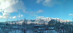
Kondur or Kandoora is the largest village in the Sukhnag River valley, located on the eastern banks of the Sukhnag River. It lies on the Beerwah-to-Doodhpathri road and is 26 kilometres (16 mi) from Srinagar, the largest city and summer capital of the union territory of Jammu and Kashmir,[3] which is the southern portion of the wider Indian-administered Kashmir region.
Kandoora is a rural village, with agriculture its main economic activity. It is a Muslim community, with the inhabitants' first language being Koshur (Kashmiri), with other languages in use for particular purposes.
- ^ "The Jammu and Kashmir Official Languages Act, 2020" (PDF), The Gazette of India, Government of India, 27 September 2020, retrieved 27 September 2020
- ^ Yattoo, Irfan (22 September 2020). "Parliament passes JK Official Languages Bill, 2020". Rising Kashmir. Archived from the original on 20 February 2022.
- ^ Manzoor, Mir (22 September 2018). "Terrorist over ground workers arrested, Beerwah". Indiatv. Archived from the original on 27 November 2020.