 Global Information
Kalamazoo River information
| Kalamazoo River | |
|---|---|
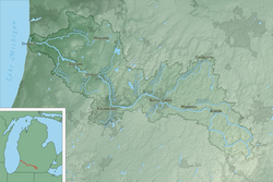 Map of the Kalamazoo River watershed | |
| Physical characteristics | |
| Source | |
| • location | South Branch : Near North Adams |
| • coordinates | 41°59′05″N 84°30′59″W / 41.98476°N 84.51633°W[1] North Branch: Near Farewell and Pine Hills lakes, Jackson County 42°05′47″N 84°28′38″W / 42.09643°N 84.47717°W[2] |
| Mouth | |
• location | Lake Michigan |
• coordinates | 42°40′36″N 86°12′55″W / 42.67669°N 86.21531°W[3] |
| Length | 130 miles (210 km) |
| Basin size | 5,230 km2 (2,020 sq mi) |
| Discharge | |
| • average | Marshall: 9.1 m3/s (320 cu ft/s)[4] Battle Creek: 19.4 m3/s (690 cu ft/s)[5] Comstock: 26.5 m3/s (940 cu ft/s)[5] Allegan : 45.8 m3/s (1,620 cu ft/s)[6] New Richmond: 52.8 m3/s (1,860 cu ft/s)[7] |
The Kalamazoo River is a river in the U.S. state of Michigan. The river is 130 miles (210 km) long from the junction of its North and South branches to its mouth at Lake Michigan, with a total length extending to 178 miles (286 km) when one includes the South Branch.[8] The river's watershed drains an area of approximately 2,020 square miles (5,200 km2) and drains portions of ten counties in southwest Michigan: Allegan, Barry, Eaton, Van Buren, Kalamazoo, Calhoun, Jackson, Hillsdale, Kent and Ottawa. The river has a median flow of 1,863 cubic feet per second (52.8 m3/s) at New Richmond, upstream from its mouth at Saugatuck and Douglas.
The north and south branches of the Kalamazoo River originate within a few miles of each other. The south branch begins near North Adams in Moscow Township in northeastern Hillsdale County and flows north and west through Homer before joining the north branch at the forks of the Kalamazoo River in Albion. The North Branch begins near Farwell and Pine Hills lakes in southern Jackson County and flows north and west through Concord before reaching Albion in Calhoun County. It then flows through Kalamazoo and Allegan counties.
After Albion, the Kalamazoo flows mostly westward through Marshall, Battle Creek, Augusta, Galesburg, Comstock, and Kalamazoo. From Kalamazoo, the river flows mostly north until just before it reaches Plainwell and then flows northwest through Otsego, Allegan, Saugatuck and then into Lake Michigan.
Some of the larger tributaries of the Kalamazoo are Rice Creek, Wilder Creek, Wabascon Creek, Battle Creek River, Augusta Creek, Portage Creek, Gun River, Swan Creek, and Rabbit River.
- ^ "South Branch Kalamazoo River". Geographic Names Information System. United States Geological Survey, United States Department of the Interior.
- ^ "North Branch Kalamazoo River". Geographic Names Information System. United States Geological Survey, United States Department of the Interior.
- ^ "Kalamazoo River". Geographic Names Information System. United States Geological Survey, United States Department of the Interior.
- ^ Mean of the yearly mean streamflows recorded by the USGS for the period 2002-2006.
- ^ a b Mean of the yearly mean streamflows recorded by the USGS for the period 2000-2006.
- ^ Mean of the yearly mean streamflows recorded by the USGS for the period 2001-2005.
- ^ Mean of the yearly mean streamflows recorded by the USGS for the period 2003-2006.
- ^ U.S. Geological Survey. National Hydrography Dataset high-resolution flowline data. The National Map Archived 2012-03-29 at the Wayback Machine, accessed May 19, 2011