Between 5.5 million (some volcanic features) with major uplift between 1 million and 150 thousand years ago5.5–0.15 Ma
PreꞒ
Ꞓ
O
S
D
C
P
T
J
K
Pg
N
Mountain type
Mostly andestic and some rhyolitic formations
Type of rock
Predominantly andesite and rhyolite volcanics
Volcanic arc
Coromandel Volcanic Zone
Last eruption
1.53 million years ago
Climbing
Easiest route
State Highway 29 (New Zealand) (North-South track, Hendersons Tramline, Ngamuwahine track)[1]
Normal route
State Highway 2 (New Zealand) (Mount Karangahake Walk, Waitawheta Pipeline Walk and most eastern tracks)[1]
Access
As well as above State Highway 26 (New Zealand) (Te Arohoa track), Te Arohoa Gordon Road, Old Te Arohoa Road (Te Tuhi track) and State Highway 24 (New Zealand)[1]
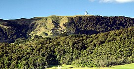
Kaimai Range forms a backdrop to Tauranga Harbour
The Kaimai Range (sometimes referred to as the Kaimai Ranges) is a mountain range in the North Island of New Zealand. It is part of a series of ranges, with the Coromandel Range to the north and the Mamaku Ranges to the south. The Kaimai Range separates the Waikato in the west from the Bay of Plenty in the east.
The highest point of the range is Mount Te Aroha (953 m), at the foot of which is the town of Te Aroha.[1] The range's terrain is rough, and only two roads pass over it: State Highway 2, across the northern end of the range through Karangahake Gorge, and State Highway 29 from Tauranga to Hamilton. Mt Te Aroha can be described as the northern head peak of the Kaimai Range.
The New Zealand Ministry for Culture and Heritage gives a translation of "eat fermented food" for Kaimāī.[2]
The Kaimai Ranges feature in local Māori folklore. The name Te Aroha translates from Māori as Te - The & Aroha - Love. Literally "the love". The name comes from a Māori legend that the sun god - male - loved the moon goddess - female. They never could see each another due to the planets positions. One day the moon goddess came to earth to see the sun god, knowing the risks, was turned to stone as the daylight came. Hers was the ultimate expression of love: Te Aroha in Māori. This is why on the Kaimai Range, to the right of Mt Te Aroha is a high skyline silhouetted rock that from afar is shaped as a woman. It is known locally as the rock of Hinemoa.
Within the Kaimai Ranges the Hendersons Tramline loop track follows the route of bush tramlines and haul lines once used to extract logs from the bush. The walk includes forest and clearings near the fringe of the park. A side track off the main walk leads down to the base of a waterfall and a large swimming hole.
Also some 10–16 km, on the Gordon backroad from te Aroha is a four-wheel drive track named Thomsons track, that takes venturers from the foothills around manawaru to the ranges top, where a large swimming hole is present.
^ abcdeNZTopoMap Te Aroha
^"1000 Māori place names". New Zealand Ministry for Culture and Heritage. 6 August 2019.
The KaimaiRange (sometimes referred to as the KaimaiRanges) is a mountain range in the North Island of New Zealand. It is part of a series of ranges, with...
the immediate south of the KaimaiRange and can be thought of as an extension of it, in much the same way that the KaimaiRange can be considered an extension...
The Kaimai Tunnel is a railway tunnel through the KaimaiRange in the North Island of New Zealand. Since it was opened in 1978, it has held the title of...
Hapuakohe Range Herangi Range Huiarau Range Humboldt Mountains Hundalee Hills Hunter Mountains Hunua Ranges Kā Mauka-Tokoweka Kaikōura RangesKaimaiRange Kaitake...
the south of the Coromandel Range, separated by the winding Karangahake Gorge, the bone continues with the KaimaiRange. The large island of Great Barrier...
Schouten Islands, north of New Guinea) Kaimai Breeze (turbulent wind with strong downdrafts in the KaimaiRange of North Island, New Zealand) Nor'wester...
Moutohora Branch). The Kaimai Tunnel runs for 8,896 m under the KaimaiRanges. Construction started from both sides of the range in 1969: the headings...
foot of 952 metres (3,123 ft) Mount Te Aroha, the highest point in the KaimaiRange. The name Te Aroha derives from the Māori name of Mount Te Aroha. In...
This crash was the worst aviation disaster in New Zealand until the KaimaiRange crash in 1963. The wreckage still remains at the crash site, with the...
can continue onto the North South track that runs the length of the KaimaiRanges. The track is about 5 km (3.1 mi) return to the lower lookout and climbs...
stretch of coastline can be seen in either direction, as well as the KaimaiRange to the west. Mount Maunganui covers 9.88 km2 (3.81 sq mi) and had an...
flight, a Douglas DC-3 Skyliner, flew into a vertical rock face in the KaimaiRanges near Mount Ngatamahinerua, at an altitude of 2460 feet (750 m). Twenty-three...
423676; 175.725514 The Karangahake Gorge lies between the Coromandel and Kaimairanges, at the southern end of the Coromandel Peninsula in New Zealand's North...
Aroha is Māori for 'love', and Te Aroha is a rural town west of the KaimaiRange, near Ardern's former home town of Morrinsville. After growing rumours...
Barrier Island in the north, through the Coromandel Peninsula, to the KaimaiRange in the south. The area of transition between it and the newer and still...
volcanoes of the Coromandel Peninsula that make up the northern part of the KaimaiRange, towards the Taupō Volcanic Zone. It was the site, about 2.1 million...
a town in Waikato, New Zealand. It is located near the base of the KaimaiRanges, and is a thriving farming area known for Thoroughbred horse breeding...
mine, an abandoned mine on the western slopes of Mount Te Aroha in the KaimaiRange of New Zealand, considered to be the most contaminated site in the country...
952 m (3,123 ft) (highest point in the KaimaiRange) Mount Matthews – 940 m (3,080 ft) (highest peak in Rimutaka Range) Mount Herbert (Te Ahu Patiki) – 920 m...
rush. Later (5–2 Ma), volcanic activity moved further south to form the KaimaiRange. After this, activity shifted further East to the Taupō Volcanic Zone...
southern limit stretches from the Kawhia Harbour in the west to the eastern KaimaiRange. However, its distribution has changed greatly over geological time because...
is an abandoned mine on the western slopes of Mount Te Aroha in the KaimaiRange of New Zealand. It was considered to be the most contaminated site in...
Zealand's North Island. It flows initially north from its source in the KaimaiRange before turning southeast to meet the Mangakarengorengo River 19 kilometres...
 Global Information