0.82 m (0.00051 mi) at Jitpur-Saguna cross section
• maximum
7.74 m (0.00481 mi) at Sibpur-Hatishala cross section
Discharge
• location
Bhagirathi-Hooghly
Basin features
Tributaries
• left
Bhairab Khal (different from Bhairab river and a different channel), Kesto-Raier Khal, Saraswati Khal, Anjana River
• right
Sialmari, Bhairab River, Chhoto Bhairab, Gobra-Suti Nala, Kalma Khal
Van den Brouck's map of 1660
Jalangi River (Bengali: জলঙ্গী নদী), is a branch of the Ganges river in Murshidabad and Nadia districts in the Indian state of West Bengal. It flows into the Bhagirathi river and strengthens its lower channel, the Hooghly.[1]
The river below the point where the Jalangi meets the Ganges is known as the Hooghly and the course above it, from the point of its separation from the main flow of the Ganges to its confluence with the Jalangi, is called the Bhagirathi.[2]
Ghurni, a neighbourhood of Krishnanagar, a centre for the production of clay dolls, often referred to as Krishnanagar clay dolls, is located on the banks of the Jalangi. Nabadwip, the birthplace of Chaitanya Mahaprabhu is located in the west bank of the united flow of river Jalangi and Bhagirathi.[3] Mayapur is located at the confluence of the Jalanagi and Bhagirathi.
^Majumdar, Dr. R.C., History of Ancient Bengal, First published 1971, Reprint 2005, p. 4, Tulshi Prakashani, Kolkata, ISBN 81-89118-01-3.
^Bandopadhyay, Dilip Kumar, Bharater Nadi (Rivers of India), 2002, (in Bengali), p. 68, Bharati Book Stall, 6B Ramanath Mazumdar Street, Kolkata
^Das, Balai Chandra; Ghosh, Sandipan; Islam, Aznarul; Roy, Suvendu (27 October 2020). Anthropogeomorphology of Bhagirathi-Hooghly River System in India. CRC Press. p. 387. ISBN 978-1-000-19457-9.
JalangiRiver (Bengali: জলঙ্গী নদী), is a branch of the Ganges river in Murshidabad and Nadia districts in the Indian state of West Bengal. It flows into...
Jalangi is a village, with a police station, identified in 2011 census, in Jalangi CD Block in Domkol subdivision of Murshidabad district in the state...
district, West Bengal, India. It's situated at the confluence of the JalangiRiver and the Bhagirathi, a tributary of the Ganges. The area is considered...
Damodar River Barakar River Jahnavi RiverJalangiRiverRiver Churni Ichamati River Rupnarayan River Ajay River Mayurakshi River Dwarakeswar River Mundeswari...
development block. The Anjana River originates on the southern bank of the JalangiRiver at the northern end of Krishnanagar, the river generally flows south...
and created a natural river border between India and Bangladesh. Jalangi area of the district was seriously affected by River bank erosion of Padma....
Ichamati RiverJalangiRiver Jaldhaka River Jamuna River Kalindi River Kangsabati River Kaljani River kapaleswari River Karatoya River Keleghai River Ketha...
Jalangi Assembly constituency is an assembly constituency in Murshidabad district in the Indian state of West Bengal. As per orders of the Delimitation...
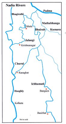
list of rivers in the Nadia district, located in the West Bengal state of India. The district has four important rivers: JalangiRiver Hooghly River Churni...
level. Ganges flows on the western side of the temple premises, while Jalangiriver flows on the southern side. A. C. Bhaktivedanta Swami Prabhupada founded...
17th-century maharajah (king). Changes to a nearby distributary of the JalangiRiver resulted partly from water diversion down the canal. Sedimentation eventually...
cargo respectively, and expected to reach 100 MT by fy 2021–22. List of rivers of India Multi-Modal Logistics Parks in India National Waterways Act, 2016...
is home to many rivers. The Padma, now the main distributary of the Ganga, touches the district on its northeastern end. The Jalangi, which flows from...
The Bhairab River and the JalangiRiver, which join together (then known as Jalangi) before joining the Bhagirathi. The Mathabhanga River, which divides...
Karimpur is a census town, near the bank of riverJalangi, in Karimpur I CD block in the Tehatta subdivision of the Nadia district in the Indian state...
Dwarekeswar river (113 km), Icchamoti river (634 km), Jalangiriver (131 km), Rupnarayan river (72 km), Subarnarekha river (314 km) and Sunderban Waterways...
subdivision in British India. 8km 5miles B A N G L A D E S H Bhairab RiverJalangiRiver Kishorpur R Nazirpur R Natidanga R Betai R Palashipara R Rahmatpur...
Kasim Bazar. 8km 5miles Tomb of Mir Madan H JalangiRiver Dwaraka River Mayurakshi River Bhagirathi River Panchthupi R Nagar R Khargram R Gram Salkia...
the Jalangi, and further eastwards towards Faridpur. The Bhairab is no more a very active river. The Mathabhanga is a younger stream than Jalangi and...
village has a population of 16,350. Barnia is situated on the west of JalangiRiver. It is on the south of Biljiala, west of Hanspukuria, north of Uzirpur...
India-Bangladesh border area. 8km 5miles B A N G L A D E S H Bhairab RiverJalangiRiver Kishorpur R Nazirpur CT Natidanga R Betai CT Palashipara R Rahmatpur...
Bhairab RiverJalangiRiver Padma River Bhagirathi River Khushbagh H Shaikhpara R Sagarpara R Sadikhanr Diar R Raninagar R Kasbagoas R Jalangi R Domkal...
government general degree college nestled on the pleasant banks of JalangiRiver at Tehatta in Nadia district of the state of West Bengal, India. The...
Bhairab RiverJalangiRiver Padma River Bhagirathi River Khushbagh H Shaikhpara R Sagarpara R Sadikhanr Diar R Raninagar R Kasbagoas R Jalangi R Domkal...
referred to as Krishnanagar clay dolls. 8km 5miles B A N G L A D E S H JalangiRiverRiver Bhagirathi Bethuadahari Wildlife Sanctuary T Palashi H Mayapur H...
 Global Information