For the settlement in Bangladesh, see Baharampur, Bangladesh. For other uses, see Berhampore (disambiguation).
Not to be confused with Berhampur.
City in West Bengal, India
Berhampore
Baharampur
City
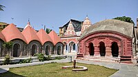
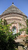
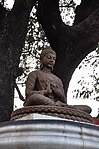
From top, left to right : Maa Dayamoyee Kalibari, Shiva Temple in Saidabad, Seated Budhha, Dutch Graveyard, Armenian Church at Saidabad, Murshidabad University, Berhampore Court railway station
Berhampore (pronounced[bɑ:(h)ərəmˌpʊə],[citation needed]Bengali pronunciation:[bɔ.ɦɔ.rɔm.pur]), also known as Baharampur, is a city and a municipality in the state of West Bengal, India. Berhampore is the administrative headquarters of the Murshidabad district. As of 2011 census, Berhampore is the seventh largest city in West Bengal. It is located about 200 km (124 mi) from Kolkata, the state capital.
It is one of the most important business, administrative, educational and political hub of Bengal as well as of India. Congress Lok Sabha leader Adhir Ranjan Chowdhury has been elected from this city since 1999. It is one of the most popular urban agglomerations of West Bengal state. It was the first centre of East India Company in India. Not only the British but also the Dutch and the French established their companies in this city and, as a result, it grew as a production hub of India. It is famous for its famous sweets such as Chanabora, Manohara, Rasgulla and many more. The city is divided into five administrative regions: Gora Bazar, Khagra, Indraprastha, Cossimbazar, Haridasmati. Berhampore was a part of Sepoy Mutiny of 1857 which took place at Berhampore Cantonment region (Barrack Square). It was used by many foreign traders as their production hub. Before becoming a city many janpadas such as Saidabad; Farasdanga; Kalikapur had become famous. Cossimbazar had also become world famous for its muslin clothes. This city used to be the headquarters of Rajshahi administrative region till 1875.
Berhampore (pronounced [bɑ:(h)ərəmˌpʊə],[citation needed] Bengali pronunciation: [bɔ.ɦɔ.rɔm.pur]), also known as Baharampur, is a city and a municipality...
Baharampur Lok Sabha constituency (earlier known as Berhampore) is one of the 543 parliamentary constituencies in India. The constituency centres on Baharampur...
Berhampore is a proposed district in Malda division, West Bengal. The district will be formed by dividing the Murshidabad district. On 1 August 2022, Chief...
Berhampore subdivision is an administrative subdivision of Murshidabad district in the state of West Bengal, India. The Bhagirathi River splits the district...
Berhampore Court is a railway station on the Sealdah-Lalgola line and is located in Murshidabad district in the Indian state of West Bengal. It serves...
Berhampore Primary School is a state primary school in the city of Wellington, in the Wellington region of New Zealand. The school vision is "Berhampore...
Sabha since 2021 and from 2019 to 2021 and the Member of Parliament from Berhampore since 1999. He is also the current president of West Bengal Pradesh Congress...
other side of the river and there are attractions in the neighbouring Berhampore area also (not shown in the map). Note: The map alongside presents some...
Berhampore may refer to: Baharampur, formerly known as Berhampore (also sometimes spelt Behrampore), a city of Murshidabad district, West Bengal, India...
Daulatabad, Gurudaspur, Hatinagar and Manindranagar gram panchayats of Berhampore community development block. Baharampur Assembly constituency is part...
stations in Murshidabad and is second important station in Berhampore(the other being Berhampore Court railway station) town which lies on the Eastern side...
Berhampore College (So renamed in 1975), popularly known as Commerce College, was established in 1963, initially as Raja Krishnath College of Commerce...
populated district and the ninth most populous in India (out of 640). Berhampore city is the headquarters of the district. The Murshidabad city, which...
Karnasubarna was an ancient city, located in the present day Berhampore CD block in the Berhampore subdivision of Murshidabad district, West Bengal, India...
Nawab's H. E. School, Murshidabad and later at Krishna Nath College, Berhampore. He received a Government Scholarship and graduated from the University...
Krishnath College School Address 4, Krishnath Road Berhampore , West Bengal , 742101 India Coordinates 24°05′29″N 88°14′45″E / 24.091362°N 88.245834°E...
Cossimbazar is a sub-urban area of Berhampore city in the Berhampore CD block in the Berhampore subdivision of Murshidabad district in the Indian state...
The Berhampore State Flats (also known as the Centennial Flats) at 493–507 Adelaide Road, Berhampore, Wellington, New Zealand, are an example of mass housing...
January 2006. The station is linked to the Sealdah–Ranaghat–Krishnanagar–Berhampore–Lalgola line and is served by the Eastern Railway for trains to Naihati...
Beldanga is a municipality town under the Berhampore subdivision of Murshidabad district in the state of West Bengal, India. Beldanga is an important trade...
Kalyani university Asannagar Madan Mohan Tarkalankar College Berhampore College Berhampore Girls' College Bethuadahari College Chakdaha College Chapra...
Bellevue School 1–6 Coed Newlands State 259 [160] 2806 Berhampore School 1–6 Coed Berhampore State 263 [161] 2808 Brooklyn School 1–8 Coed Brooklyn State...
 Global Information