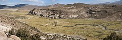
The Isluga River flowing past a lava flow from Isluga Volcano.
Native name
Río Isluga(Spanish)
Physical characteristics
Source
Confluence of Chaguane and Huinchuta
Mouth
Laguna Mucalliri, Salar de Coipasa
Length
54 kilometres (34 mi)
Basin size
2,450 square kilometres (950 sq mi)
Discharge
• location
Bocatoma
• average
0.4–0.5 m3/s (14–18 cu ft/s)
• minimum
Less than 0.3 m3/s (11 cu ft/s)
• maximum
More than 0.75 m3/s (26 cu ft/s)
Basin features
Tributaries
• left
Quebrada Taipicollo, Alsare
• right
Mauque, sometimes Cariquima River is considered a tributary
Isluga River is a river in Chile and Bolivia, and is also known as Sitani or Arabilla. It starts at the confluence of the rivers Chaguane and Huinchuta and flows for 54 kilometres (34 mi) before reaching the Laguna Mucalliri of the Salar de Coipasa. It receives water from the volcanoes Isluga, Cabaray and Quimsachata as well as the Sierra Uscana.
The watershed of the river lies mainly in Chile and has a dry climate, resulting in a small river discharge of about 0.4–0.5 cubic metres per second (14–18 cu ft/s). There are a number of towns and hamlets in the catchment, as well as wetlands with a number of animal and plant species.
IslugaRiver is a river in Chile and Bolivia, and is also known as Sitani or Arabilla. It starts at the confluence of the rivers Chaguane and Huinchuta...
Tarapacá Region (Chile), on the shores of the Arabilla lagoon and the Islugariver. It is located 26 km from Colchane and 1 km from Enquelga. Its inhabitants...
and Chapicollo. The town has several hot springs which connect to the IslugaRiver. publimetro. "Parques nacionales: estos son los que están abiertos y...
Biomphalaria snails and oribatid mites. These fish are also found in the IslugaRiver watershed; most likely they came to Huasco through a past connection...
parks in Chile covering a total area of 13,206,810 hectares. Lauca Volcán Isluga Llullaillaco Pan de Azúcar Nevado Tres Cruces Llanos de Challe Fray Jorge...
Region, Chile. It is located within the area of the Volcán Isluga National Park, in the Chiapa river ravine. The term Mauque comes from the Quechua mauca meaning...
accessed either from the sea along the Huemules River valley or by land via the valley of the Blanco River from Lago Elizalde-Lago Claro. Small populations...
Quechua, "chimba" means "on the other side" as in "on the other side of the river" or "on the opposite bank." Other dialects pronounce this word "chimpa."...
foothills stretch almost to the edge of the Magdalena River, north of the volcano and the Cauca River to the west. On the two major sides of the summit,...
Fauna Reserve Sajama National Park Salar del Huasco National Park Volcan Isluga National Park Yura National Park Chungará Lake and Nevado Sajama Salar de...
devastating lahars which would travel down the flanks of the volcano, guided by river valleys whose origins lie at the volcano. Danger from normal, explosive...
and Quebrada Quenoal. Most of them eventually join the San Juan de Oro River, which flows into the Atlantic Ocean. Panizos can be accessed through these...
the Rio Arma is a tributary of the Ocoña River, while to the east, the Colca River is part of the Majes River watershed. An endorheic area that receives...
Salar de Atacama. Southwest of Licancabur are the Vilama and San Pedro rivers, which flow to San Pedro de Atacama. Starting in the Jurassic, the Farallon...
southeast before joining the Lauca River. The other rivers draining Sajama and its ice cap also eventually join the Lauca River and end in the Salar de Coipasa...
the Cordillera Oriental by the lowland valley of the Cosanga and Quijos Rivers. There are more than 6000 species of vascular plants, including more than...
stretches 26 km south from the small town of Colchane, just outside the Volcán Isluga National Park, to the village of Cariquima. The trail reaches altitudes...
straits of Chile List of islands of Chile List of lakes of Chile List of rivers of Chile Lists of volcanoes Ring of Fire Volcanism of Chile Search database...
The name Ojos del Salado [ˈo.xos d̪el saˈla.ð̞o] refers to a river, Río Salado ("Salty River"), that a 1937 Polish expedition used to reach the mountain...
Volcanic Zone include Sabancaya, El Misti and Ubinas in Peru and Tacora, Isluga, Irruputuncu, Ollague, San Pedro, Putana, Alitar, Lascar and Lastarria in...
 Global Information