Global Information Lookup Global Information

Irish Sea Glacier information


The Irish Sea Glacier was a huge glacier during the Pleistocene Ice Age that, probably on more than one occasion, flowed southwards from its source areas in Scotland and Ireland and across the Isle of Man, Anglesey and Pembrokeshire.[1] It probably reached its maximum extent during the Anglian Glaciation, and it was also extensive during the Late Devensian Glaciation (or Last Glacial Maximum).

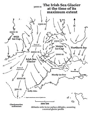
It was the only clearly defined major glacier in the Irish Sea and flowed about 700 km from its source areas to its southernmost margin. It is sometimes referred to as an “ice stream” since it appears to have been constrained not by ice-free land areas but by highlands which were themselves buried beneath ice. At the time of its maximum extent the glacier extended all the way to the coasts of Somerset and Cornwall, along the south coast of Ireland, and even reached the Isles of Scilly.

It was forced through a relatively narrow constriction in St George's Channel by ice flowing from the Irish Ice Cap (to the west) and the Welsh Ice Cap (to the east). At one point the glacier was probably no more than 80 km wide.

Once through this constriction, in the Anglian Glaciation, the ice spread out into a great lobe, in the area now occupied by the Celtic Sea and the approaches to the Bristol Channel. On the eastern flank of the glacier, the evidence of striations, glacial deposits and "erratic trains" shows that the edge of the Irish Sea Glacier was pushed southwards by ice coming from the Welsh ice cap on the Brecon Beacons, so that Irish Sea ice flowed parallel with the coast of South Wales and then came into contact with the English coast around the Somerset Levels, between Exmoor and the Mendips. It is not known how far inland this ice extended, but there are scattered glacial deposits in the Bridgwater - Glastonbury district—these may mark the easternmost extent of the glacier. On its western flank the Irish Sea Glacier reached Cork Harbour. The maximum width of this great ice lobe was more than 320 km. "Old" glacial deposits in South wales and in Pembrokeshire are still not accurately dated.

Currently there is a great debate about the dating of the Devensian glaciation of the Isles of Scilly. The ice of the Irish Sea Glacier certainly pressed against the northern coasts of the islands, and accumulating evidence seems to show that this occurred some time after 24,000 years ago.[2] During this same glacial episode the ice of the Irish Sea Glacier also swept along the southern Irish coast as far west as Cork, and reached its outer limit about 100 km to the SW of the Isles of Scilly. Research suggests that the ice was grounded everywhere and not floating; this is consistent with the view that sea-level at the LGM was around 120m lower than it is today. Even further out in the southwest approaches, the ice edge was floating and calving. One current theory is that the glacier moved to its outermost position by a "lobate surge partially propagated by high porewater pressures within deformable marine substrate",[3] leaving parts of South Wales, the Bristol Channel and the coasts of SW England free of glacier ice.

However, glaciers have to behave according to the laws of ice physics, and a long narrow lobate surge with a flat long profile would be difficult to explain. Tightly confined "valley glaciers" do not exist on open tundra situations (such as this must have been at the time) especially if the glacier bed rises southwards. Glacier ice in those circumstances must have "backed up" and spread sideways. It is most likely that when the Irish Sea Glacier reached its southernmost extent, the glacier surface must have been at c 2,000m in St George's Channel, c 2,250m over the Isle of Anglesey, and c 2,500m over the Isle of Man. It follows that the mountains of Wales and Eastern Ireland must also have been submerged beneath thick glacier ice at the time. Furthermore, the Bristol Channel is most likely to have been ice-filled at the LGM, as indicated on the adjoining map.

Recent work[4] suggests that the area outside the South Ireland End Moraine was inundated by Irish Ice during and after the LGM. At the same time parts of the area outside the South Wales End Moraine must also have been inundated by ice.

Another puzzle is the extent to which the long profile of the Irish Sea Glacier, at the time of its maximum extent, approximated to the classic equilibrium profile. Work in analogous situations in Marie Byrd Land, Antarctica,[5] suggests that the ice surface altitude over the mountains might have been around 800m lower than predicted.

  1. ^ Lewis, CA and Richards, AE 2005 "The Glaciations of Wales and adjacent areas," Logaston Press, 228 pp.
  2. ^ Smedley, R.K. et al (2017) New age constraints for the limit of the British–Irish Ice Sheet on the Isles of Scilly. Journal of Quaternary Science 32(1), pp 48–62.
  3. ^ Scourse, J.D.; Furze, M.F.A. (2006), "Glacial marine geology of the Celtic Shelf and Goban Spur -- Porcupine continental margin", Isles of Scilly Field Guide, QRA, pp. 23–27
  4. ^ O'Cofaigh, C.; Evans, D.J.A. (2007). "Radiocarbon Constraints on the age of the maximum advance of the British-Irish Ice Sheet in the Celtic Sea". Quaternary Science Reviews. 26: 1197–1203. doi:10.1016/j.quascirev.2007.03.008.
  5. ^ Sugden, D.E.; et al. (2004). "Selective glacial erosion and weathering zones in the coastal mountains of Marie Byrd Land, Antarctica". Geomorphology. 67: 317–334. doi:10.1016/j.geomorph.2004.10.007.

and 29 Related for: Irish Sea Glacier information

Request time (Page generated in 0.8311 seconds.)

Irish Sea Glacier

Last Update:

The Irish Sea Glacier was a huge glacier during the Pleistocene Ice Age that, probably on more than one occasion, flowed southwards from its source areas...

Word Count : 992

Glaciology

Last Update:

Society International Association of Cryospheric Sciences Irish Sea Glacier List of glaciers Cryosphere Williams, Richard S. (1987). "Summary Remarks"...

Word Count : 1497

Ice age

Last Update:

for Quaternary Research – International science organisation Irish Sea Glacier – Huge glacier during the Pleistocene Ice Age Last Glacial Maximum – Circa...

Word Count : 10428

Stonehenge

Last Update:

they were brought much nearer to the site as glacial erratics by the Irish Sea Glacier although there is no evidence of glacial deposition within southern...

Word Count : 14459

Bluestone

Last Update:

geologists Richard Bevins and Rob Ixer. If a glacier transported the stones, then it must have been the Irish Sea Glacier. In support of the glacial erratic theory...

Word Count : 2062

Isles of Scilly

Last Update:

Early Permian age, an exposed part of the Cornubian batholith. The Irish Sea Glacier terminated just to the north of the Isles of Scilly during the last...

Word Count : 8597

Past sea level

Last Update:

glaciers, polar ice caps and sea ice. Over geological timescales, changes in the shape of the oceanic basins and in land/sea distribution affect sea level...

Word Count : 3310

List of seas on Earth

Last Update:

often a top-level division of an ocean or sea Fjord – a long bay with steep sides, typically formed by a glacier Bight – a bay that is typically shallower...

Word Count : 2757

Amundsen Sea

Last Update:

Thwaites Glaciers, which both flow into the Amundsen Sea, are two of Antarctica's largest five. Researchers reported that the flow of these glaciers increased...

Word Count : 1965

List of places on land with elevations below sea level

Last Update:

by the largest glacier in the world. Therefore, it is not included in any list on the page. If the ice melted it would be covered by sea. The biggest dry...

Word Count : 471

Barnaslingan

Last Update:

draining the ice sheet which covered the Irish Midlands close to its zone of convergence with Irish Sea Glacier. The channel carried huge amounts of subglacial...

Word Count : 812

Sea level rise

Last Update:

melting ice sheets and glaciers accounted for 44% of sea level rise, with another 42% resulting from thermal expansion of water.: 1576  Sea level rise lags behind...

Word Count : 21163

Last Glacial Period

Last Update:

severe in others. During this last glacial period, alternating episodes of glacier advance, and retreat occurred. Within the last glacial period, the Last...

Word Count : 5349

Geography of Ireland

Last Update:

the sea level has risen and fallen. In every area of the country, the rocks which formed can be seen as a result. Finally, the impact of the glaciers shaped...

Word Count : 7908

Esker

Last Update:

the Irish word eiscir (Old Irish: escir), which means "ridge or elevation, especially one separating two plains or depressed surfaces". The Irish word...

Word Count : 1452

Sea

Last Update:

frozen, found in the sea ice covering the Arctic Ocean, the ice cap covering Antarctica and its adjacent seas, and various glaciers and surface deposits...

Word Count : 18796

Glossary of landforms

Last Update:

depressions of the sea floor Outwash fan – Type of sediment deposition by a melting glacier Outwash plain – Plain formed from glacier sediment transported...

Word Count : 8327

Prehistoric Ireland

Last Update:

regarded as having been carried to Ireland on an ice sheet, probably from what is now the bottom of the Irish Sea. In 2021, a reindeer bone fragment discovered...

Word Count : 7256

Drumlin

Last Update:

it has been suggested that this ratio can indicate the velocity of the glacier. That is, since ice flows in laminar flow, the resistance to flow is frictional...

Word Count : 3202

Fjord

Last Update:

fiord (/ˈfjɔːrd, fiːˈɔːrd/ ) is a long, narrow sea inlet with steep sides or cliffs, created by a glacier. Fjords exist on the coasts of Antarctica, the...

Word Count : 6175

Killary Harbour

Last Update:

Galway. ... only a few hundred metres wide. A glacier must have scoured the bottom as it moved towards the sea, taking large volumes of rock and gravel with...

Word Count : 1275

List of cliffs by continent

Last Update:

overall drop from East Summit to Dunge Glacier). Northwest Face drops approximately 2,200 m to the Trango Glacier below, but with a taller slab topped out...

Word Count : 2088

Iceberg that sank the Titanic

Last Update:

within the context of climate change. The sea ice is receding and the melting of the Greenland glaciers will initially create more icebergs. However...

Word Count : 7173

Sea level

Last Update:

time scales. Current sea level rise is mainly caused by human-induced climate change. When temperatures rise, mountain glaciers and polar ice sheets melt...

Word Count : 4284

Crag and tail

Last Update:

mountain, generally isolated from other high ground. Crags are formed when a glacier or ice sheet passes over an area that contains a particularly resistant...

Word Count : 313

McMurdo Dry Valleys

Last Update:

bacteria, with a metabolism based on iron and sulfur, live under the Taylor Glacier. The valleys are located within the McMurdo Valleys Antarctic Specially...

Word Count : 2034

Aral Sea

Last Update:

on 11 December 2021. Retrieved 18 July 2009. "Videos - From the Glaciers to the Aral Sea - Water Unites". www.waterunites-ca.org. Archived from the original...

Word Count : 9543

Plateau

Last Update:

enormous glaciers. The polar ice cap is so massive that the echolocation measurements of ice thickness have shown that large areas are below sea level....

Word Count : 1913

List of fish of Ireland

Last Update:

series of papers in Irish Naturalists' Journal and records of rare marine fish species taken in Irish waters by fishing vessels and sea anglers from 1786...

Word Count : 2428

PDF Search Engine © AllGlobal.net