Anglesey and Holy Island, Isle of Man and Calf of Man, Bardsey Island, Walney, Lambay, Ireland's Eye
Settlements
(see below)
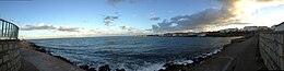
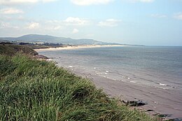
Location of the Irish SeaFrom the pier at Dún Laoghaire a suburban seaside town in County Dublin, IrelandDublin BayBrittas Bay
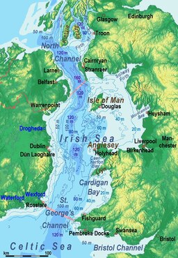
The Irish Sea[a] is a 46,007 km2 (17,763 sq mi) body of water that separates the islands of Ireland and Great Britain. It is linked to the Celtic Sea in the south by St George's Channel and to the Inner Seas off the West Coast of Scotland[4] in the north by the North Channel. Anglesey, North Wales, is the largest island in the Irish Sea, followed by the Isle of Man. The term Manx Sea may occasionally be encountered (Welsh: Môr Manaw, Irish: Muir Meann[5] Manx: Mooir Vannin, Scottish Gaelic: Muir Mhanainn).[6][7][8]
On its shoreline are Scotland to the north, England to the east, Wales to the southeast, Northern Ireland and the Republic of Ireland to the west. The Irish Sea is of significant economic importance to regional trade, shipping and transport, as well as fishing and power generation in the form of wind power and nuclear power plants. Annual traffic between Great Britain and Ireland amounts to over 12 million passengers and 17 million tonnes (17,000,000 long tons; 19,000,000 short tons) of traded goods.
^"Muir Éireann". téarma.ie – Dictionary of Irish Terms. Foras na Gaeilge and Dublin City University. Archived from the original on 10 May 2017. Retrieved 18 November 2016.
^"Ellan Vannin" (in Manx). Centre for Manx Studies ("Laare-Studeyrys Manninagh"). Archived from the original on 4 March 2011. Retrieved 8 July 2011.
^Cambridge Medieval Celtic Studies, Issues 33–35 University of Cambridge (Gran Bretaña). Department of Anglo-Saxon, Norse and Celtic 1997
^Cite error: The named reference IHO was invoked but never defined (see the help page).
^Electronic Dictionary of the Irish Language
^Bannerman, David Armitage (1963). The Birds of the British Isles: Volume 12. Edinburgh: Oliver and Boyd. p. 84. OCLC 725928669.
^"The Caledonian". The Caledonian. 4. New York: Caledonian Publishing Co.: 25 1903.
^"Irish Sea Facts". Irish Sea Conservation. Archived from the original on 11 May 2011. Retrieved 3 July 2011.
Cite error: There are <ref group=lower-alpha> tags or {{efn}} templates on this page, but the references will not show without a {{reflist|group=lower-alpha}} template or {{notelist}} template (see the help page).
The IrishSea is a 46,007 km2 (17,763 sq mi) body of water that separates the islands of Ireland and Great Britain. It is linked to the Celtic Sea in the...
The IrishSea Bridge, sometimes called the Celtic Crossing by the media, is a hypothetical rail and road bridge that would span the IrishSea and connect...
The IrishSea border is an informal term for the trade border between Northern Ireland and Great Britain. It was specified by the Ireland/Northern Ireland...
industrialists, and Unionist politicians". In 1885, Irish Builder and Engineer said a tunnel under the IrishSea had been discussed "for some time back". In 1890...
This is a list of islands in the IrishSea. Listed below are islands in the IrishSea which are over 1 km2 in area, or which have a permanent population:...
Great Britain to its east by the North Channel, the IrishSea, and St George's Channel. Ireland is the second-largest island of the British Isles, the...
Dover IrishSea Celtic Sea Iroise Sea Bay of Biscay Cantabrian Sea Gulf of Cádiz Mediterranean Sea Alboran Sea Mar Menor Balearic (Catalan) Sea Gulf of...
A sea is a large body of salty water. There are particular seas and the sea. The sea commonly refers to the ocean, the wider body of seawater. Particular...
in 2013, due north of Dunquin, off County Clare on the Irish West Coast Dalkey Island - IrishSea prospect Various blocks licensed for exploration, several...
Govan's Head]. Wikimedia Commons has media related to Celtic Sea. Irish Conservation Box Irish: An Mhuir Cheilteach [ənˠ wɪrʲ ˈçɛlʲtʲax]; Welsh: Y Môr Celtaidd...
IrishSea freight-only route". The Irish News. 19 February 2024. Retrieved 23 February 2024. "Stena Rederi closes deal to sell the vessel Urd to Sea Lines...
The IrishSea Glacier was a huge glacier during the Pleistocene Ice Age that, probably on more than one occasion, flowed southwards from its source areas...
different seas: the IrishSea, the Celtic Sea and the Atlantic Ocean. Also shown are two tables. Table 1 shows the longest rivers in Ireland with their...
border in Ireland, so that (in many respects) the de facto frontier is the IrishSea border between the two islands. This requires the continued application...
exacerbated by the bursting of the Irish property bubble. The Irish name for Ireland is Éire, deriving from Ériu, a goddess in Irish mythology. The state created...
After securing his position domestically, Magnus campaigned around the IrishSea from 1098 to 1099. He raided through Orkney, the Hebrides and Mann (the...
United Kingdom. Irish newspapers are also available in the UK, and Irish state and private television are widely available in Northern Ireland. Certain reality...
Sargasso Sea (/sɑːrˈɡæsoʊ/) is a region of the Atlantic Ocean bounded by four currents forming an ocean gyre. Unlike all other regions called seas, it has...
marginal seas: the Baltic Sea, the Black Sea, the Caribbean Sea, the Gulf of Mexico, the English Channel, the Labrador Sea, the Mediterranean Sea, the mid-Atlantic...
(/lɒx/) is a word meaning "lake" or "sea inlet" in Scottish and Irish Gaelic, subsequently borrowed into English. In Irish contexts, it often appears in the...
slavery. Gaelic raiders kidnapped and enslaved people from across the IrishSea for two centuries after the Fall of the Western Roman Empire destabilising...
Look up Irish in Wiktionary, the free dictionary. Irish may refer to: Someone or something of, from, or related to: Ireland, an island situated off the...
ended the Northern Ireland Conflict. The Protocol instead creates a de facto customs border in the IrishSea between Northern Ireland and Great Britain...
Atlantic Ocean, the North Sea, the English Channel, the Celtic Sea, and the IrishSea. The total area of the United Kingdom is 94,354 square miles (244...
mountains. The highest peak is Carrauntoohil (Irish: Corrán Tuathail), which is 1,039 metres (3,409 ft) above sea level. The western coastline is rugged, with...
 Global Information