For the Preston Reed album, see Instrument Landing (album).
Diagram of an instrument landing system (ILS) approach
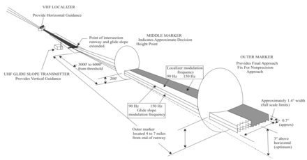
In aviation, the instrument landing system (ILS) is a precision radio navigation system that provides short-range guidance to aircraft to allow them to approach a runway at night or in bad weather. In its original form, it allows an aircraft to approach until it is 200 feet (61 m) over the ground, within a 1⁄2 mile (800 m) of the runway. At that point the runway should be visible to the pilot; if it is not, they perform a missed approach. Bringing the aircraft this close to the runway dramatically increases the range of weather conditions in which a safe landing can be made. Other versions of the system, or "categories", have further reduced the minimum altitudes, runway visual ranges (RVRs), and transmitter and monitoring configurations designed depending on the normal expected weather patterns and airport safety requirements.
View of the primary component of the ILS, the localizer, which provides lateral guidance. The transmitter and antenna are on the centerline at the opposite end of the runway from the approach threshold. Photo of Indra's Normarc localizer, taken at the runway 06L of the Montréal–Trudeau International Airport, Canada.
ILS uses two directional radio signals, the localizer (108 to 112 MHz frequency), which provides horizontal guidance, and the glideslope (329.15 to 335 MHz frequency) for vertical guidance. The relationship between the aircraft's position and these signals is displayed on an aircraft instrument, often additional pointers in the attitude indicator. The pilot attempts to manoeuvre the aircraft to keep the indicators centered while they approach the runway to the decision height. Optional marker beacon(s) provide distance information as the approach proceeds, including the middle marker (MM), placed close to the position of the (CAT 1) decision height. Markers are largely being phased out and replaced by distance measuring equipment (DME). The ILS usually includes high-intensity lighting at the end of the runways to help the pilot locate the runway and transition from the approach to a visual landing.[1]
A number of radio-based landing systems were developed between the 1920s and 1940s, notably the Lorenz beam which saw relatively wide use in Europe prior to World War II. The US-developed SCS-51 system was more accurate while also adding vertical guidance. Many sets were installed at airbases in the United Kingdom during World War II, which led to it being selected as the international standard after the formation of the International Civil Aviation Organization (ICAO) in 1947. Several competing landing systems have been developed, including the radar-based ground-controlled approach (GCA) and the more recent microwave landing system (MLS), but few of these systems have been deployed. ILS remains a widespread standard to this day.
The introduction of precision approaches using global navigation satellite systems (GNSSs) instead of requiring expensive airport infrastructure is leading to the replacement of ILS. Providing the required accuracy with GNSS normally requires only a low-power omnidirectional augmentation signal to be broadcast from the airport, which is dramatically less expensive than the multiple, large and powerful transmitters required for a full ILS implementation. By 2015, the number of US airports supporting ILS-like LPV approaches exceeded the number of ILS installations,[2] and this is expected to lead to the eventual removal of ILS at most airports.
^Wragg, David W. (1973). A Dictionary of Aviation (1st ed.). Osprey. p. 143. ISBN 9780850451634.
^"Satellite Navigation - GPS/WAAS Approaches".
and 28 Related for: Instrument landing system information
In aviation, the instrumentlandingsystem (ILS) is a precision radio navigation system that provides short-range guidance to aircraft to allow them to...
An instrumentlandingsystem localizer, or simply localizer (LOC, or LLZ prior to 2007), is a system of horizontal guidance in the instrumentlanding system...
navigation system that provides course and glidepath guidance. Examples include precision approach radar (PAR), instrumentlandingsystem (ILS), and GBAS...
the correct glidepath for a safe landing. MLS was intended to replace or supplement the instrumentlandingsystems (ILS). MLS has a number of operational...
materials arrestor system Helipad Highway strip ICAO recommendations on use of the International System of Units Instrumentlandingsystem (ILS) List of airports...
omnidirectional range-instrumentlandingsystem (VOR-ILS) display. This reduces pilot workload by lessening the number of elements in the pilot's instrument scan to...
all-weather approaches via an InstrumentLandingSystem-style display. While JPALS is similar to Local Area Augmentation System, but intended primarily for...
transponder landingsystem (TLS) is an all-weather, precision landingsystem that uses existing airborne transponder and instrumentlandingsystem (ILS) equipment...
of the InstrumentLandingSystem (ILS) at Seletar Airport by Singapore was disputed by Malaysia, saying that the flight path used by the system may encroach...
with contributing causes including the crew's failure to use the instrumentlandingsystem (ILS), as well as pilot fatigue. A retired pilot stated the runway...
the runway and struck multiple airport approach lights and the instrumentlandingsystem before eventually becoming airborne. The aircraft suffered severe...
radio beacon used in aviation, usually in conjunction with an instrumentlandingsystem (ILS), to give pilots a means to determine position along an established...
The McDonnell Douglas MD-83 struck trees and an instrumentlandingsystem (ILS) antenna during landing, causing $9 million in damage to the aircraft.: 1...
Paris-Frankfurt-Paris segment by Avianca for operational reasons. During the instrumentlandingsystem (ILS) approach to runway 33, the 747 crashed on a hill approximately...
other systems for providing some sort of detection capability in low visibility. Many night fighters of the conflict also included instrumentlanding systems...
000 feet. In 1958 the instrumentlandingsystem to runway 28 was augmented with a 3,000-foot high-intensity-approach lighting system. With the use of the...
with Instrumentlandingsystem (ILS) installations with Night Landing Facilities at most of these airports and an Automatic Message Switching System at...
99 mi) to the east of 02L/20R. Four instrumentlandingsystems (ILS) are installed on the two runways to guide landing aircraft safely under all weather...
instrument to visual flight. Sequenced flashing lights are sometimes colloquially called the rabbit or the running rabbit. Instrumentlandingsystem (ILS)...
the aircraft touched down, but it overran the runway, hit the InstrumentLandingSystem localizer antenna at an altitude of approximately 5 ft (1.5 m)...
international scheduled services. The airport is equipped with a CAT 1 instrumentlandingsystem, on-site aircraft rescue and firefighting, and a fully serviced...
 Global Information