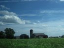
Topographic map depicting the Hunterdon PlateauFarm in Alexandria Township
Hunterdon Plateau is a plateau in western Hunterdon County, New Jersey. It borders the higher Musconetcong Mountain to the northwest, the Delaware River to the west, Amwell Valley to the south and the lower lying areas of the Newark Basin to the east.
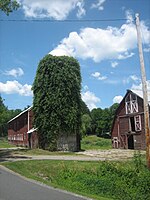
Barn along the Capoolong Trail and Kingstown Road Hunterdon Plateau
The plateau's edge follows a line from Raven Rock to Flemington. From there it follows a curved path west of the South Branch Raritan River until it meets with the Musconetcongs.[1] It is generally unmarred as a plateau, excluding some of the small valleys of tributaries along the Delaware, of Lopatcong Creek and Wickecheoke Creek and Cakepoulin/Capoolong Creek Valley. Other features are Thatcher's Hill and Sand Hill which form southeastward extensions to the plateau due to a valley of Walnut Brook and the curve of the plateau there.
This also occurs between Lockatong Valley and the Delaware River. A small ridge called Barren Ridge runs through Alexandria and Union Township rises slightly above the rest of the plateau. Another feature in Holland Township called Gravel Hill also rises above the rest of the plateau. There are numerous cliffs along the Delaware where the plateau meets it such as Milford Bluffs where prickly pear cacti grow, a rarity in Hunterdon County.[2] The plateau includes the boroughs of Milford and Frenchtown, as well as part of the borough of Flemington and parts of Kingwood, Raritan, Franklin, Union, Bethlehem, Alexandria, Delaware, and Holland townships. Because of the soil types and relatively flat terrain on the plateau, there are still many farms across the area.
^New Jersey Geographical Survey. "Final Report, Volume 4". University of Michigan, 1808
HunterdonPlateau is a plateau in western Hunterdon County, New Jersey. It borders the higher Musconetcong Mountain to the northwest, the Delaware River...
Amwell Valley Black Dirt Region (shared with New York) Great Valley HunterdonPlateau Ridge-and-Valley Appalachians Highlands Somerset Hills The Sourlands...
The Amwell Valley is a small valley in Hunterdon County, New Jersey, between the HunterdonPlateau and the Sourlands. It comprises Stockton, parts of...
Route 12 is a state highway located in Hunterdon County, New Jersey, United States. It runs 11.69 mi (18.81 km) from the Uhlerstown–Frenchtown Bridge...
the Delaware River in Hunterdon County, New Jersey in the United States. It originates in Raritan Township on the HunterdonPlateau and flows through Croton...
mountain range, the area is actually a dissected plateau, a sub-section of the larger Allegheny Plateau, forming a 2,400-square-mile (6,200 km2) escarpment...
the Delaware River, at the point where the creek cuts down from the HunterdonPlateau. It includes Green Sergeant's Covered Bridge (a covered bridge bringing...
Catskills form the northeastern end of the Allegheny Plateau (also known as the Appalachian Plateau). The Catskills were named by early Dutch settlers....
341 Morris County, New Jersey 491,845 Sussex County, New Jersey 140,488 Hunterdon County, New Jersey 124,371 Pike County, Pennsylvania 55,809 Bridgeport-Stamford-Norwalk...
341 Morris County, New Jersey 491,845 Sussex County, New Jersey 140,488 Hunterdon County, New Jersey 124,371 Pike County, Pennsylvania 55,809 Bridgeport-Stamford-Norwalk...
(97 km) through Central New Jersey in Middlesex, Somerset, Mercer, and Hunterdon counties. 40°22′7.27″N 74°36′58.14″W / 40.3686861°N 74.6161500°W /...
River in Bucks County; in New Jersey, the AVA spans along the river in Hunterdon County and Mercer County from Titusville, New Jersey, just north of Trenton...
 Global Information