 Global Information
Hiwassee River information
| Hiwassee River | |
|---|---|
 The Hiwassee River as it flows through Murphy, July 2022 | |
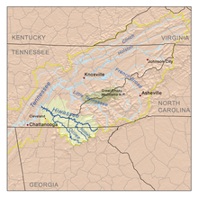 The Hiwassee drainage basin | |
| Location | |
| Country | United States |
| State | Georgia, North Carolina, Tennessee |
| Physical characteristics | |
| Source | North slope of Rocky Mountain in Towns County, Georgia[1][2] |
| • coordinates | 34°48′4″N 83°44′4″W / 34.80111°N 83.73444°W[2] |
| • elevation | 3,640 ft (1,110 m)[1] |
| Mouth | Tennessee River at Hiwassee Island in Meigs County, Tennessee |
• coordinates | 35°24′36″N 85°0′36″W / 35.41000°N 85.01000°W[2] |
• elevation | 682 ft (208 m)[2] |
| Length | 147 mi (237 km)[3][4] |
| Basin size | 2,700 sq mi (7,000 km2)[5] |
| Discharge | |
| • location | at the Apalachia Dam powerhouse, 53.2 miles (85.6 km) above the mouth(average for the years 1942-1979)[6] |
| • average | 2,431 cu ft/s (68.8 m3/s)(average for the years 1942-1979)[6] |
| • minimum | 30 cu ft/s (0.85 m3/s) September 1955[6] |
| • maximum | 47,100 cu ft/s (1,330 m3/s) May 1973[6] |
| Basin features | |
| Progression | Tennessee River → Ohio River → Mississippi River → Gulf of Mexico |
| River system | Tennessee River |
| Tributaries | |
| • left | Soapstone Creek, Wheeler Branch, Spainard Branch, Owl Creek, The Gorge, Sparks Branch, Fodder Creek, Woodring Branch, Sutton Branch, Hog Creek, Woods Creek, Mill Creek, Blair Creek, Town Creek, Qually Creek, Poplar Creek, Owenby Creek, Coot Cove, Walnut Cove, Passmore Branch, Carver Branch, Anderson Branch, Suddawig Branch, Brasstown Creek, Penland Creek, Hampston Creek, Right Prong, Nottely River, Beech Creek, Persimmon Creek, Bearpaw Creek, Micken Creek, Shouth Shoal Creek, Baine Branch, Camp Creek, Laurel Branch, Shadwick Branch, Ball Shanty Cove, Turtletown Creek, Wolf Creek, Little Branch, Butler Branch, Big Hopper Camp Branch, Smith Creek, Little Jobe Patch Branch, Big Lost Creek, Ellis Creek, Junebug Creek, Spring Falls Branch, Tieskee Creek, Lowry Branch, Spanking Stump Branch, Pell Branch, Lillard Branch, Horton Branch, Raht Chapel Branch, Ocoee River, Bacon Branch, Chestuee Creek, Parker Branch, Chatcha Creek, South Mouse Creek, Candies Creek, Roger Creek, Gunstocker Creek, Coppinger Creek, Lick Branch |
| • right | High Shoals Creek, Corbin Creek, Brown Branch, Mill Creek, Big Brown Cove, Cynth Creek, Hightower Creek, Bearmeat Creek, Allen Mill Creek, Shake Rag Branch, Bell Creek, Reed Branch, Sneaking Branch, Shooting Creek, Downing Creek, Sandersen Cove, Tusquittee Creek, Carver Creek, Bob Branch, Allbone Branch, Mob Branch, Fires Creek, Watson Branch, Betty Branch, Auberry Branch, Calhoun Branch, Sudderth Branch, Mission Branch, McComb Branch, Peachtree Branch, Fall Branch, Burnthouse Branch, Will Scott Creek, Valley River, Hanging Dog Creek, Grape Creek, Hyatt Mill Creek, Taylor Branch, Chambers Creek, Beaverdam Creek, Rose Creek, Anderson Creek, Beavers Branch, North Shoal Creek, Adams Branch, Shuler Creek, Brushy Creek, Watertank Branch, Miller Cove, Womble Branch, Rough Branch, Land Branch, Coker Creek, Loss Creek, Towee Creek, Cappy Branch, Beach Bottom Branch, Plum Branch, Childers Creek, Presswood Branch, Ernie King Hollow, Ruckers Branch, Hopper Branch, Spring Creek, Watertank Branch, Coffee Branch, Gee Creek, Siccowee Branch, Dairy Branch, Hawkins Branch, Conasauga Creek, Spearman Branch, Frog Hollow Branch, Chestutee Creek, Horse Branch, McKnight Hollow, Ben Liner Hollow, Squire Liner Hollow, Oostanauta Creek, North Mouse Creek, Silvils Creek, Rogers Creek, Racepath Hollow, Price Creek, Agency Creek, Bird Hollow, Roberts Hollow |
The Hiwassee River originates from a spring on the north slope of Rocky Mountain in Towns County in the northern area of the State of Georgia. It flows northward into North Carolina before turning westward into Tennessee, flowing into the Tennessee River a few miles west of what is now State Route 58 in Meigs County, Tennessee. The river is about 147 miles (237 km) long.[3]
- ^ a b U.S. Geological Survey. Tray Mountain quadrangle, Georgia. 1:24,000. 7.5 Minute Series. Washington D.C.: USGS, 1985.
- ^ a b c d U.S. Geological Survey Geographic Names Information System: Hiwassee River
- ^ a b "U.S. Geological Survey. National Hydrography Dataset high-resolution flowline data". Viewer.nationalmap.gov. Archived from the original on March 29, 2012. Retrieved April 27, 2011.
- ^ Hiwassee History
- ^ U.S. Geological Survey, "Introduction to the Upper Tennessee River Basin," 11 January 2013. Accessed: 31 May 2015.
- ^ a b c d United States Geological Survey, Water Resources Data Tennessee: Water Year 1979, Water Data Report TN-79-1, p. 199. Gaging station 03556500.