 Global Information
Heightmap information
This article needs additional citations for verification. (December 2009) |
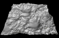
In computer graphics, a heightmap or heightfield is a raster image used mainly as Discrete Global Grid in secondary elevation modeling. Each pixel stores values, such as surface elevation data, for display in 3D computer graphics. A heightmap can be used in bump mapping to calculate where this 3D data would create shadow in a material, in displacement mapping to displace the actual geometric position of points over the textured surface, or for terrain where the heightmap is converted into a 3D mesh.
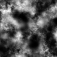
A heightmap contains one channel interpreted as a distance of displacement or "height" from the "floor" of a surface and sometimes visualized as luma of a grayscale image, with black representing minimum height and white representing maximum height. When the map is rendered, the designer can specify the amount of displacement for each unit of the height channel, which corresponds to the “contrast” of the image. Heightmaps can be stored by themselves in existing grayscale image formats, with or without specialized metadata, or in specialized file formats such as Daylon Leveller, GenesisIV and Terragen documents.
One may also exploit the use of individual color channels to increase detail. For example, a standard RGB 8-bit image can only show 256 values of grey and hence only 256 heights. By using colors, a greater number of heights can be stored (for a 24-bit image, 2563 = 16,777,216 heights can be represented (2564 = 4,294,967,296 if the alpha channel is also used)). This technique is especially useful where height varies slightly over a large area. Using only grey values, because the heights must be mapped to only 256 values, the rendered terrain appears flat, with "steps" in certain places.

Heightmaps are commonly used in geographic information systems, where they are called digital elevation models.