 Global Information
Hauhungatahi information
| Hauhungatahi | |
|---|---|
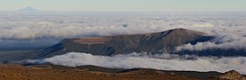 Hauhungatahi seen from Mount Ruapehu | |
| Highest point | |
| Elevation | 1,521 m (4,990 ft)[1] |
| Prominence | approx 400 m (1,300 ft)[citation needed] |
| Coordinates | 39°13′46″S 175°26′39″E / 39.22944°S 175.44417°E |
| Naming | |
| Language of name | Māori |
| Geography | |
 Hauhungatahi North Island, New Zealand | |
| Topo map | nz49931[1] |
| Geology | |
| Age of rock | |
| Mountain type | stratovolcano |
| Volcanic arc/belt | Taupo Volcanic Zone |
| Climbing | |
| Easiest route | Tramping from the west, starting near Erua |
 Map centered on Hauhungatahi to show nearby approximate selected surface volcanic deposits with andesite in red shading. To its immediate west is the andesite of Mount Ruapehu and Mount Tongariro. To its north west is Lake Rotoaira and beyond that the andesitic deposits of Pihanga. Rhyolitic ignimbrite surface deposits to the north of the map are various shades of violet from eruptions of the Taupō Volcano. Clicking on the map enlarges it, and enables panning and mouseover of volcano name/wikilink and ages before present. Key for the volcanics that are shown with panning is: basalt (shades of brown/orange), monogenetic basalts, undifferentiated basalts of the Tangihua Complex in Northland Allochthon, arc basalts, arc ring basalts, dacite, andesite (shades of red), basaltic andesite, rhyolite, (ignimbrite is lighter shades of violet), and plutonic. White shading is selected caldera features. | |
Hauhungatahi is an eroded andesitic volcano at the southern end of the Taupo Volcanic Zone in New Zealand, located about 12 kilometres (7 mi) north–west of Mount Ruapehu.[2]: 179 Although relatively little-known, at 1,521 metres (4,990 ft) Hauhungatahi is one of the highest volcanoes in New Zealand, exceeded in elevation by only Ruapehu, Taranaki/Egmont (including Fanthams Peak), and the Tongariro massif (including Ngauruhoe).
- ^ a b "Topographic map, nz49931". Retrieved 21 February 2021.
- ^ a b Cameron, E.; Gamble, J; Price, R.; Smith, I.; McIntosh, W.; Gardner, M. (2009). "The petrology, geochronology and geochemistry of Hauhungatahi volcano, S.W. Taupo Volcanic Zone". Journal of Volcanology and Geothermal Research. 190 (1–2): 179–191. Bibcode:2010JVGR..190..179C. doi:10.1016/j.jvolgeores.2009.07.002.