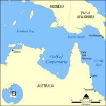
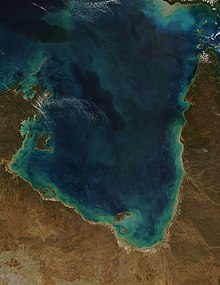
The location of the Gulf of Carpentaria. It covers a water area of about 300,000 km2 (120,000 sq mi).The Gulf of Carpentaria from an 1859 Dutch mapThe Gulf of Carpentaria between Bentinck Island and the Australian continentLoading ore from McArthur River zinc mine at Bing Bong Loading Facility, 2011Gulf of Carpentaria from MODISKarumba Beach, Karumba, QueenslandMelbidir II anchored off Karumba near the mouth of the Norman River
The Gulf of Carpentaria (/kɑːrpənˈtɛəriə/) is a sea off the northern coast of Australia. It is enclosed on three sides by northern Australia and bounded on the north by the eastern Arafura Sea, which separates Australia and New Guinea. The northern boundary is generally defined as a line from Slade Point, Queensland (the northwestern corner of Cape York Peninsula) in the northeast, to Cape Arnhem on the Gove Peninsula, Northern Territory (the easternmost point of Arnhem Land) in the west.
At its mouth, the Gulf is 590 km (370 mi) wide, and further south, 675 km (420 mi). The north-south length exceeds 700 km (430 mi). It covers a water area of about 300,000 km2 (120,000 sq mi). The general depth is between 55 and 66 metres (30 and 36 fathoms) and does not exceed 82 metres (45 fathoms).[1] The tidal range in the Gulf of Carpentaria is between two and three metres (6.5 and 10 ft).[2] The Gulf and adjacent Sahul Shelf were dry land at the peak of the last ice age 18,000 years ago when global sea level was around 120 m (390 ft) below its present position. At that time a large, shallow lake occupied the centre of what is now the Gulf.[3] The Gulf hosts a submerged coral reef province that was only recognised in 2004.[4]
^"Sector 1: North Coast of Australia – Gulf of Carpentaria". Sailing Directions (enroute).: North, west, and south coasts of Australia. National Imagery and Mapping Agency. 2001. p. 3. Retrieved 6 October 2020. or Sector 1: North Coast of Australia – Gulf of Carpentaria
^Cite error: The named reference ewcl was invoked but never defined (see the help page).
^Torgersen, T., Hutchinson, M.F., Searle, D.E., Nix, H.A., 1983. General bathymetry of the Gulf of Carpentaria and the Quaternary physiography of Lake Carpentaria. Palaeogeogr., Palaeoclimatol., Palaeoecol. 41, 207-225
^Harris, P.T., Heap, A.D., Marshall, J.F., McCulloch, M.T., 2008. A new coral reef province in the Gulf of Carpentaria, Australia: colonisation, growth and submergence during the early Holocene. Marine Geology 251, 85-97.
and 23 Related for: Gulf of Carpentaria information
The GulfofCarpentaria (/kɑːrpənˈtɛəriə/) is a sea off the northern coast of Australia. It is enclosed on three sides by northern Australia and bounded...
objective was the crossing of Australia from Melbourne in the south to the GulfofCarpentaria in the north, a distance of around 3,250 kilometres (approximately...
occurs as an amplitude-ordered series of waves forming bands of roll clouds. The southern part of the GulfofCarpentaria in Northern Australia is the only...
displacement of Aboriginal communities and the arrival of Torres Strait Islanders on the mainland. The west coast borders the GulfofCarpentaria and the east...
Shire ofCarpentaria is a local government area in Far North Queensland, Australia on the GulfofCarpentaria, for which it is named. The Shire of Carpentaria...
The Gulf Country or North West Queensland is the region of woodland and savanna grassland surrounding the GulfofCarpentaria in north western Queensland...
GulfofCarpentaria Marine Park (formerly known as the GulfofCarpentaria Commonwealth Marine Reserve) is an Australian marine park in the Gulfof Carpentaria...
the north coast of Western Australia GulfofCarpentaria, in Northern Australia Gulfof Cazones, in southern Cuba Gulfof Corinth, of the Ionian Sea separating...
northeastern Northern Territory, south of the GulfofCarpentaria. It includes much of Queensland's Gulf Country, and a portion of the Barkly Tableland in the Northern...
Australian mainland from Papua New Guinea, and the GulfofCarpentaria to the north-west. With an area of 1,723,030 square kilometres (665,270 sq mi), Queensland...
Indonesian part of the Island of New Guinea. The Arafura Sea is bordered by the GulfofCarpentaria and the continent of Australia to the south, the Timor...
000 km2 Timor Sea - 610,000 km2 Java Sea - 320,000 km2 Gulfof Thailand - 320,000 km2 GulfofCarpentaria - 300,000 km2 Celebes Sea - 280,000 km2 Sulu Sea -...
Picture of the Day Archive". NASA. Retrieved June 1, 2014.. Clarke, R. H.; Smith, R. K.; Reid, D. G. (1981). "The Morning Glory of the GulfofCarpentaria: An...
the coast of New Guinea, missed Torres Strait, and explored and then charted part of the western side of Cape York, in the GulfofCarpentaria, believing...
Persian Gulf (Persian: خلیج فارس, romanized: xalij-e fârs, lit. 'Gulfof Fars', pronounced [xæliːdʒe fɒːɾs]), sometimes called the Arabian Gulf (Arabic:...
the Northern Territory of Australia. It is located on the McArthur River, about 50 km (31 mi) upstream from the GulfofCarpentaria. Borroloola lies on the...
The Gulfof Guinea is the northeasternmost part of the tropical Atlantic Ocean from Cape Lopez in Gabon, north and west to Cape Palmas in Liberia. Null...
coastal plains along the GulfofCarpentaria. To the east lie aeolian dunefields. Along the eastern margin, the geology of the Coen-Yambo Inlier is complex...
The Gulfof California (Spanish: Golfo de California), also known as the Sea of Cortés (Mar de Cortés) or Sea of Cortez, or less commonly as the Vermilion...
The Gulfof Mexico (Spanish: Golfo de México) is an ocean basin and a marginal sea of the Atlantic Ocean, mostly surrounded by the North American continent...
coast of New Guinea, missed Torres Strait, and explored perhaps 350 kilometres (220 mi) of western side of Cape York, in the GulfofCarpentaria, believing...
 Global Information