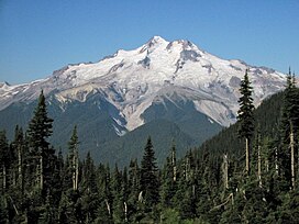
Glacier Peak or Dakobed (known in the Sauk-Suiattle dialect of the Lushootseed language as "Tda-ko-buh-ba" or "Takobia"[5]) is the most isolated of the five major stratovolcanoes (composite volcanoes) of the Cascade Volcanic Arc in the U.S state of Washington. Located in the Glacier Peak Wilderness in Mount Baker–Snoqualmie National Forest, the volcano is visible from the west in Seattle, and from the north in the higher areas of eastern suburbs of Vancouver such as Coquitlam, New Westminster and Port Coquitlam. The volcano is the fourth tallest peak in Washington state, and not as much is known about it compared to other volcanoes in the area. Local Native Americans have recognized Glacier Peak and other Washington volcanoes in their histories and stories. When American explorers reached the region, they learned basic information about surrounding landforms, but did not initially understand that Glacier Peak was a volcano. Positioned in Snohomish County, the volcano is only 70 miles (110 km) northeast of downtown Seattle. From locations in northern Seattle and northward, Glacier Peak is closer than the more famous Mount Rainier (Tahoma), but as Glacier Peak is set farther into the Cascades and almost 4,000 feet (1,200 m) shorter, it is much less noticeable than Mount Rainier.
Glacier Peak is one of the most active of Washington's volcanoes. The volcano formed during the Pleistocene epoch, about one million years ago, and since the most recent ice age, it has produced some of the largest and most explosive eruptions in the state. When continental ice sheets retreated from the region, Glacier Peak began to erupt regularly, erupting explosively five times in the past 3,000 years. It has erupted repeatedly during at least six periods; two of these eruptions have been among the largest in Washington.
^ abc"Glacier Peak, Washington". Peakbagger.com. Retrieved October 17, 2012.
^"Glacier Peak". NGS Data Sheet. National Geodetic Survey, National Oceanic and Atmospheric Administration, United States Department of Commerce. Retrieved December 20, 2008.
^ abc"Glacier Peak". Global Volcanism Program. Smithsonian Institution. Retrieved January 8, 2009.
^Cite error: The named reference Beckey was invoked but never defined (see the help page).
^Bedal Fish, Jean; Bedal, Edith (2000). Two Voices – A History of the Sauk and Suiattle People, and Sauk Country Experiences. Astriba R. Blukis Onat.
GlacierPeak or Dakobed (known in the Sauk-Suiattle dialect of the Lushootseed language as "Tda-ko-buh-ba" or "Takobia") is the most isolated of the five...
GlacierPeak Wilderness is a 566,057-acre (229,075 ha), 35-mile-long (56 km), 20-mile-wide (32 km) wilderness area located within portions of Chelan, Snohomish...
PeakGlacier is a glacier situated at the base of Wheeler Peak within Great Basin National Park in the U.S. state of Nevada. It is the only glacier in...
which are about 145 and 108 cubic miles (600 and 450 km3) respectively. GlacierPeak is the only Cascade volcano that is made exclusively of dacite. The history...
elevation of GlacierPeak (DaKobed) includes an adjustment of +1.492 m (4.9 ft) from NGVD 29 to NAVD 88. The elevation of Bonanza Peak includes an adjustment...
predominantly non-volcanic, but include the stratovolcanoes Mount Baker, GlacierPeak and Coquihalla Mountain, which are part of the Cascade Volcanic Arc....
Spain Peak east to Dahe Glacier are, from west to east, Spain Peak, Anu Whakatoro Glacier, Tūkeri Peak, Fenwick Glacier, Ringer Valley, Ringer Glacier, Templeton...
447407; 167.561469. A peak about 890 metres (2,920 ft) high, located 1.5 nautical miles (2.8 km; 1.7 mi) west of Terra Nova Glacier and 2 nautical miles...
GlacierPeak High School is a high school in Snohomish, Washington, United States, operated by the Snohomish School District. GlacierPeak was opened in...
of Martin Peninsula and Smith Glacier. The range consists of two ice-covered plateaus punctuated by several rock peaks and bluffs. The plateaus are oriented...
Glacier. It forms the northernmost part of the Denton Hills. Hobbs Ridge, which includes Hobbs Peak, Goat Mountain, Mount Kowalczyk and Williams Peak...
of Pyke Glacier and Albone Glacier, 4.1 kilometres (2.5 mi) southwest of Zasele Peak and 5.15 kilometres (3.20 mi) northeast of Kopriva Peak. Steep and...
Kolahoi Peak rises from the Kolahoi Glacier is a pyramid-shaped peak with ice falls and ice fields at its bottom. The rock formation of the peak is extraordinary...
Peak, and is about 17 mi (27 km) north of GlacierPeak in the GlacierPeak Wilderness. Meltwater from the glacier flows directly into South Cascade Lake...
Chuck Glacier is located in the GlacierPeak Wilderness in the U.S. state of Washington and is 3.5 mi (5.6 km) south of GlacierPeak. The glacier is within...
by Sumner Glacier from the west, Cole Glacier, Lammers Glacier. Other features include Werner Peak, Norwood Scarp, Mount Solus, Eisner Peak and Mount...
Oregon (at Marys Peak), and Victoria, British Columbia. With 26 major glaciers and 36 sq mi (93 km2) of permanent snowfields and glaciers, Mount Rainier...
Stewart Glacier to McKinley Peak. From there it runs northeast past the Hershey Ridge and the Court Ridge, past the mouths of the Hammond Glacier, Swope...
Spigot Peak, Selvick Cove, Zeiss Needle, Sable Pinnacles (Noire Rock) and Henryk Peak. Central features include Wild Spur, Henryk Glacier, Pulfrich Peak, Hubl...
91444°W / -63.97028; -59.91444 A peak rising to 1,541 metres (5,056 ft) high east of Temple Glacier and south of Kasabova Glacier. Situated 2.6 kilometres (1...
 Global Information