Applied science of creating computerized representations of portions of the Earth's crust
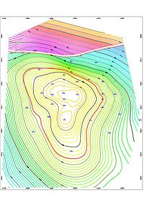
Geological mapping software displaying a screenshot of a structure map generated for an 8500ft deep gas & Oil reservoir in the Earth field, Vermilion Parish, Erath, Louisiana. The left-to-right gap, near the top of the contour map indicates a Fault line. This fault line is between the blue/green contour lines and the purple/red/yellow contour lines. The thin red circular contour line in the middle of the map indicates the top of the oil reservoir. Because gas floats above oil, the thin red contour line marks the gas/oil contact zone.
Geologic modelling,geological modelling or geomodelling is the applied science of creating computerized representations of portions of the Earth's crust based on geophysical and geological observations made on and below the Earth surface. A geomodel is the numerical equivalent of a three-dimensional geological map complemented by a description of physical quantities in the domain of interest.[1]
Geomodelling is related to the concept of Shared Earth Model;[2]
which is a multidisciplinary, interoperable and updatable knowledge base about the subsurface.
Geomodelling is commonly used for managing natural resources, identifying natural hazards, and quantifying geological processes, with main applications to oil and gas fields, groundwater aquifers and ore deposits. For example, in the oil and gas industry, realistic geologic models are required as input to reservoir simulator programs, which predict the behavior of the rocks under various hydrocarbon recovery scenarios. A reservoir can only be developed and produced once; therefore, making a mistake by selecting a site with poor conditions for development is tragic and wasteful. Using geological models and reservoir simulation allows reservoir engineers to identify which recovery options offer the safest and most economic, efficient, and effective development plan for a particular reservoir.
Geologic modelling is a relatively recent subdiscipline of geology which integrates structural geology, sedimentology, stratigraphy, paleoclimatology, and diagenesis;
In 2-dimensions (2D), a geologic formation or unit is represented by a polygon, which can be bounded by faults, unconformities or by its lateral extent, or crop. In geological models a geological unit is bounded by 3-dimensional (3D) triangulated or gridded surfaces. The equivalent to the mapped polygon is the fully enclosed geological unit, using a triangulated mesh. For the purpose of property or fluid modelling these volumes can be separated further into an array of cells, often referred to as voxels (volumetric elements). These 3D grids are the equivalent to 2D grids used to express properties of single surfaces.
Geomodelling generally involves the following steps:[3]
Preliminary analysis of geological context of the domain of study.
Interpretation of available data and observations as point sets or polygonal lines (e.g. "fault sticks" corresponding to faults on a vertical seismic section).
Construction of a structural model describing the main rock boundaries (horizons, unconformities, intrusions, faults)[4]
Definition of a three-dimensional mesh honoring the structural model to support volumetric representation of heterogeneity (see Geostatistics) and solving the Partial Differential Equations which govern physical processes in the subsurface (e.g. seismic wave propagation, fluid transport in porous media).
^Mallet, J. L. (2008). Numerical Earth Models. European Association of Geoscientists and Engineers (EAGE Publications bv). ISBN 978-90-73781-63-4. Archived from the original on 2016-03-04. Retrieved 2013-08-20.
^
Fanchi, John R. (August 2002). Shared Earth Modeling : Methodologies for Integrated Reservoir Simulations. Gulf Professional Publishing (Elsevier imprint). pp. xi–306. ISBN 978-0-7506-7522-2.
^Chen, Shang-Ying; Hsieh, Bieng-Zih; Hsu, Kuo-Chin; Chang, Yi-Fei; Liu, Jia-Wei; Fan, Kai-Chun; Chiang, Li-Wei; Han, Yin-Lung (January 2021). "Well spacing of the doublet at the Huangtsuishan geothermal site, Taiwan". Geothermics. 89: 101968. Bibcode:2021Geoth..8901968C. doi:10.1016/j.geothermics.2020.101968. S2CID 224972986.
^Caumon, G., Collon-Drouaillet, P., Le Carlier de Veslud, C., Sausse, J. and Viseur, S. (2009), Surface-based 3D modeling of geological structures, Mathematical Geosciences, 41(9):927–945
and 26 Related for: Geologic modelling information
Geologicmodelling, geologicalmodelling or geomodelling is the applied science of creating computerized representations of portions of the Earth's crust...
still in use, the table of geologic time conforms to the nomenclature, ages, and colour codes set forth by the ICS. The geologic time scale is a way of representing...
Scientific modelling is an activity that produces models representing empirical objects, phenomena, and physical processes, to make a particular part...
often known as Quaternary geology, after the Quaternary period of geologic history, which is the most recent period of geologic time. Magma is the original...
available by the British Geological Survey and used for geological data visualisation, interpretation and 3D geologicmodelling. It is available in both...
GeoModeller (old names include 3DWEG, Geomodeller3D) is a methodology and associated software tool for 3D geologicmodelling developed by Bureau de Recherches...
S., Ghosh, A. (2017). "Understanding deep earth dynamics: A numerical modelling approach". Current Science (Invited Review), 112, 1463–1473. Ghosh, A...
engineering geology problems. The methods used by engineering geologists in their studies include geologic field mapping of geologic structures, geologic formations...
landforms are classified according to both their geologic structures and histories. Distinctions based on geologic age also correspond to physiographic distinctions...
and human geography and from geology, geographers in the mid-20th century began to apply statistical and mathematical models in order to solve spatial problems...
(2013-06-01). "Uncertainty in geochemical modelling of CO2 and calcite dissolution in NaCl solutions due to different modelling codes and thermodynamic databases"...
meteorology and climate change, oceanography and coupled ocean and atmosphere modelling, business location planning, architecture and archeological reconstruction...
Different Types of 3D Modelling Techniques Polygonal Modeling – Polygonal modeling is a fundamental and widely-used technique in 3D modelling. It revolves around...
Geochemistry – Science that applies chemistry to analyze geological systems Geologicmodelling – Applied science of creating computerized representations...
United States equivalent portion is called the Appalachian Highlands. The Geologic Survey of Canada uses three levels of physiographic classification. The...
remediation and monitoring takes place. Digital geologic mapping is the process by which geological features are observed, analyzed, and recorded in...
distribution of the continents through geologic time. Almost all the evidence for the positions of the continents comes from geology in the form of fossils or paleomagnetism...
an ocean or sea, such as a continent or a large island. In the field of geology, a landmass is a defined section of continental crust extending above sea...
data is too high Geologicmodelling increased fine-scale understanding of the geological processes enhancement of the reservoir model with high resolution...
analog – Planet with environment similar to Earth's Geologic time scale – System that relates geologic strata to time Geophysics – Physics of the Earth and...
Sweden–with a view on the relationships between physical geography and geology". Geografiska Annaler. 102 (1). Swedish Society for Anthropology and Geography:...
"Cumberland Mountain Range". Geographic Names Information System. United States Geological Survey, United States Department of the Interior. Retrieved May 17, 2010...
Shawnee Counties west to east. Oklahomans generally refer to the same geologic formation as the Osage Hills or "the Osage." The Flint Hills Ecoregion...
Tennessee, North Alabama, and Kentucky which surrounds the Central Basin. Geologically, the Central Basin is a dome. The Highland Rim is a cuesta surrounding...
65J/12, available on the Onlinemaps Portal Sriramadas, A. (November 1967). "Geology of Eastern Ghats in Andhra Pradesh" (PDF). Proceedings of the Indian Academy...
 Global Information