 Global Information
Geography of Vermont information


The U.S. state of Vermont is located in the New England region of the northeastern United States and comprises 9,614 square miles (24,900 km2), making it the 45th-largest state. It is the only state that does not have any buildings taller than 124 feet (38 m).[2] Land comprises 9,250 square miles (24,000 km2) and water comprises 365 square miles (950 km2), making it the 43rd-largest in land area and the 47th in water area. In total area, it is larger than El Salvador and smaller than Haiti. It is the only landlocked state in New England, and it is the easternmost and the smallest in area of all landlocked states.
The Green Mountains in Vermont form a north–south spine running most of the length of the state, slightly west of its center. In the southwest portion of the state are located the Taconic Mountains.[3] In the northwest, near Lake Champlain, is the fertile Champlain Valley. In the south of the valley is Lake Bomoseen.
The west bank of the Connecticut River marks the state's eastern border with New Hampshire, though much of the river flows within New Hampshire's territory.[4] 41% of Vermont's land area is part of the Connecticut River's watershed.[5]
Lake Champlain, the sixth-largest body of fresh water in the United States, separates Vermont from New York in the northwest portion of the state. From north to south, Vermont is 159 miles (256 km) long. Its greatest width, from east to west, is 89 miles (143 km) at the Canada–U.S. border; the narrowest width is 37 miles (60 km) near the Massachusetts border. The width averages 60.5 miles (97.4 km). The state's geographic center is approximately three miles (5 km) east of Roxbury, in Washington County. There are fifteen U.S. federal border crossings between Vermont and Canada.
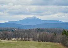
Several mountains have timberlines with delicate year-round alpine ecosystems, including Mount Mansfield, the highest mountain in the state; Killington Peak, the second-highest; Camel's Hump, the state's third-highest; and Mount Abraham, the fifth-highest peak.[6] Areas in Vermont administered by the National Park Service include the Marsh-Billings-Rockefeller National Historical Park (in Woodstock) and the Appalachian National Scenic Trail.[7]
- ^ "The NGS Data Sheet". Silver Spring, Maryland: NOAA—National Geodetic Survey (NGS). January 15, 2020. Retrieved February 11, 2020.
- ^ "Burlington high rise gets facelift", Burlington Free Press.
- ^ Edward Day Collins (1903). A History of Vermont: With Geological and Geographical Notes, Bibliography, Chronology, Maps, and Illustrations. Ginn. p. 1.
- ^ Vermont v. New Hampshire 289 U.S. 593 (1933)
- ^ "Fast Facts about the Connecticut River" Archived August 8, 2016, at the Wayback Machine. Crjc.org (October 9, 2008). Retrieved April 12, 2014.
- ^ Green Mountain Club (April 24, 2007). "Alpine Tundra". Archived from the original on November 19, 2015.
- ^ "Vermont". National Park Service. Archived from the original on June 16, 2008. Retrieved July 15, 2008.