coastal belt of mangrove swamps, wooded hill country, an upland plateau, mountains in the east[1]
Natural resources
mineral deposits (diamonds, titanium ore, bauxite, iron ore, gold, chromite)[1]
Natural hazards
dry, sand-laden Harmattan winds blow from the Sahara (December to February); sandstorms, dust storms[1]
Environmental issues
rapid population growth; deforestation from increased cattle grazing and agriculture, land degradation and flooding; biodiversity loss; air and water pollution; overfishing[1]
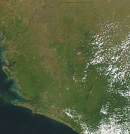
Sierra Leone is a country in West Africa with a North Atlantic Ocean coastline to the west. It lies on the African Plate. The country's main geographical features include wooded hill country, an upland plateau, and mountains in the east. The highest peak is Mount Bintumani, which is 1,948 meters (6,391 ft) above sea level. The coastline has a belt of mangrove swamps. Freetown, the nation's capital city, has one of the world's largest natural harbours.[4] The Rokel River is the largest river in Sierra Leone. It is 400 kilometres (250 mi) long and has a basin with a total area of 10,622 square kilometres (4,101 sq mi).
Sierra Leone is located at approximately 8°30′N12°06′W / 8.5°N 12.1°W / 8.5; -12.1, between the 7th and 10th parallels north of the equator. It is bordered by Guinea to the north and northeast, and Liberia to the south and southeast.[5] The country has a total area of 71,740 km2 (27,699 sq mi), divided into a land area of 71,620 km2 (27,653 sq mi) and water of 120 km2 (46 sq mi).[1]
^ abcdefg"Sierra Leone". World Factbook. CIA.gov. Retrieved 14 November 2021.
^"Rokel River". Britannia. Retrieved 14 November 2021.
^"Lake Sonfon – Sierra Leone". Living Lakes. Global Nature Fund. Retrieved 14 November 2021.
^"Sierra Leone". Britannia. Retrieved 14 November 2021.
^LeVert 2007, p. 7.
and 18 Related for: Geography of Sierra Leone information
SierraLeone is a country in West Africa with a North Atlantic Ocean coastline to the west. It lies on the African Plate. The country's main geographical...
important resource in rural areas." GeographyofSierraLeone Tristan Reed and James A. Robinson, The Chiefdoms ofSierraLeone, Scholar, Harvard University...
provided as an overview of and topical guide to SierraLeone: SierraLeone – sovereign country located in West Africa. SierraLeone is bordered by Guinea...
The chiefdoms ofSierraLeone are the third-level units of administration in SierraLeone. There are 190 chiefdoms in SierraLeone, as of 2017. Previously...
city ofSierraLeone. It is a major port city on the Atlantic Ocean and is located in the Western Area of the country. Freetown is SierraLeone's major...
SierraLeone, officially the Republic ofSierraLeone, is a country on the southwest coast of West Africa. It shares its southeastern border with Liberia...
divisions ofSierraLeone "SierraLeone unveils new geographical map". Africa Review. Retrieved 2018-02-01. Media related to Provinces ofSierraLeone at Wikimedia...
councils. Subdivisions ofSierraLeone List of districts ofSierraLeone by Human Development Index "SierraLeone unveils new geographical map". Africa Review...
The SierraLeone Creole people (Krio: Krio pipul) are an ethnic group ofSierraLeone. The SierraLeone Creole people are descendants of freed African-American...
SierraLeone first became inhabited by indigenous African peoples at least 2,500 years ago. The Limba were the first tribe known to inhabit Sierra Leone...
The economy ofSierraLeone is $4.082 billion by gross domestic product as of 2018. Since the end of the SierraLeone Civil War in 2002, the economy is...
This is a list of cities and towns in SierraLeone. The following table is the list of cities in SierraLeone by population. Other notable cities Wangechi...
Literature ofSierraLeone is the collection of written and spoken work, mostly fictional, from SierraLeone. The coastal west-African country suffered...
The SierraLeone River is a river estuary on the Atlantic Ocean in Western SierraLeone. It is formed by the Bankasoka River and Rokel River and is between...
The SierraLeone Grammar School was founded on 25 March 1845 in Freetown, SierraLeone, by the Church Mission Society (CMS), and at first was called the...
Mendiland is part of the extreme southwest portion ofSierraLeone[citation needed] on the western coast of Africa, where the Mende tribe lives and the...
The Catholic Church in SierraLeone is part of the worldwide Catholic Church, under the spiritual leadership of the Pope in Rome. There are approximately...
 Global Information