Global Information Lookup Global Information

Geography of Puerto Rico information


Puerto Rico
Native name:
Borinquen (Taino)
Nickname: La Isla del Encanto
(The Island of Enchantment)
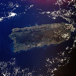
Satellite image of Puerto Rico
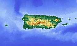
Topographic image of Puerto Rico and
Location of Puerto Rico within the Caribbean
Geography
LocationCaribbean Sea
Coordinates18°15′N 66°30′W / 18.250°N 66.500°W / 18.250; -66.500
ArchipelagoGreater Antilles
Major islandsSpanish Virgin Islands of Vieques and Culebra
Palomino
Mona
Monito
Caja de Muertos
Desecho
Area3,513 sq mi (9,100 km2)
[a][1]
Area rank4th (Caribbean Islands)
81st (World Islands)
175th (World)
Length178 km (110.6 mi)
Width65 km (40.4 mi)
Coastline501 km (311.3 mi)
Highest elevation1,338 m (4390 ft)
Highest pointCerro de Punta
Administration
United States
TerritoryPuerto Rico
Largest settlementSan Juan (pop. 342,259)
Demographics
Population3,205,691 (2023)
Pop. density361.4/km2 (936/sq mi)
Ethnic groupsWhite 80.5%, Mulatto 10.9%, Black 8.0%, Amerindian 0.4%, Asian 0.2%

The geography of Puerto Rico consists of an archipelago located between the North Atlantic Ocean and the Caribbean Sea, east of Hispaniola, west of the Virgin Islands, north of Venezuela, and south of the Puerto Rico Trench, the deepest point in the entire Atlantic. As the easternmost and smallest of the Greater Antilles, the main island of Puerto Rico is about 178 kilometers long (110 statute miles; 96 nautical miles) and 65 kilometers wide (40 statute miles; 35 nautical miles).[b] With a land and internal coastal water area of 9,100 square kilometres (3,500 sq mi),[2] it is the 4th largest island in the Caribbean and 81st largest island in the world. Various smaller islands and cays, including Vieques, Culebra, Palomino, Mona, Desecheo, and Caja de Muertos, comprise the rest of the archipelago, with only Culebra and Vieques being inhabited.

Larger than the state of Rhode Island but smaller than Connecticut, the main island of Puerto Rico is the 3rd largest island in the United States. Around 60% mountainous, it has three mountain ranges: Sierra Cayey in the southeast, Sierra Luquillo in the northeast, and Cordillera Central in the central and western region.[2] The highest elevation point in Puerto Rico, Cerro de Punta (4,390 feet or 1,338 meters),[3] is located in Cordillera Central, while El Yunque, one of the most popular peaks in Puerto Rico, located in the Sierra Luquillo at the El Yunque National Forest, has a maximum elevation of 3,540 feet (1,080 m).

The main island has seven valleys: Caguas, Yabucoa, Lajas, Añasco, the Coloso and Culebrinas, Cibuco, and Guanajibo. It has two coastal plains: one stretching alongside the northern coast, and the other alongside the southern coast. The capital, San Juan, and main metropolitan area are located on the northern costal plain in the northeast. It also has one prominent karst formation in its northwestern central region called the Northern Karst Belt, and two prominent batholiths, one in the southeast and the other in the central western region. The island has 47 major rivers and 26 reservoirs, lagoons, or lakes, among which is Laguna Grande (Big Lagoon), one of three bioluminescent bays in the archipelago of Puerto Rico located in the far northeastern town of Fajardo.[2]


Cite error: There are <ref group=lower-alpha> tags or {{efn}} templates on this page, but the references will not show without a {{reflist|group=lower-alpha}} template or {{notelist}} template (see the help page).

  1. ^ "State Area Measurements and Internal Point Coordinates". United States Census Bureau. Retrieved February 24, 2024.
  2. ^ a b c "Geografía de Puerto Rico". Sistemas de Información Geográfica (in Spanish). Retrieved February 24, 2024.
  3. ^ "Elevations and Distances in the United States". U.S. Geological Survey. April 29, 2005. Retrieved October 23, 2017.

and 19 Related for: Geography of Puerto Rico information

Request time (Page generated in 1.0835 seconds.)

Geography of Puerto Rico

Last Update:

The geography of Puerto Rico consists of an archipelago located between the North Atlantic Ocean and the Caribbean Sea, east of Hispaniola, west of the...

Word Count : 2566

Puerto Rico Trench

Last Update:

The Puerto Rico Trench is located on the boundary between the Caribbean Sea and the Atlantic Ocean. The oceanic trench, the deepest in the Atlantic, is...

Word Count : 2044

Economy of Puerto Rico

Last Update:

industry, notably finance, insurance, real estate, and tourism. The geography of Puerto Rico and its political status are both determining factors on its economic...

Word Count : 16987

Municipalities of Puerto Rico

Last Update:

municipalities of Puerto Rico (Spanish: municipios de Puerto Rico) are the second-level administrative divisions in the Commonwealth of Puerto Rico. There are...

Word Count : 1759

Outline of Puerto Rico

Last Update:

overview of and topical guide to Puerto Rico: The Commonwealth of Puerto Rico is a self-governing unincorporated territory of the United States of America...

Word Count : 1600

Climate of Puerto Rico

Last Update:

The climate of Puerto Rico in the Köppen climate classification is predominantly tropical rainforest. Temperatures throughout the year are warm to hot...

Word Count : 2043

Barrios of Puerto Rico

Last Update:

The barrios of Puerto Rico are the primary legal divisions of the seventy-eight municipalities of Puerto Rico. Puerto Rico's 78 municipios are divided...

Word Count : 2551

Puerto Rico statehood movement

Last Update:

The Puerto Rico statehood movement (Spanish: movimiento estadista de Puerto Rico) aims to make Puerto Rico a state of the United States. Puerto Rico is...

Word Count : 4995

List of Puerto Rico locations by per capita income

Last Update:

a list of Puerto Rico locations by per capita income. In 2017, Puerto Rico had a per capita income of $12,081 — lower than any state and one of the lowest...

Word Count : 324

History of Puerto Rico

Last Update:

The history of Puerto Rico began with the settlement of the Ortoiroid people before 430 BC. At the time of Christopher Columbus's arrival in the New World...

Word Count : 14768

Puerto Ricans

Last Update:

Borincanos, or Puertorros, are the people of Puerto Rico, the inhabitants and citizens of the Commonwealth of Puerto Rico and their descendants, including those...

Word Count : 7356

Puerto Rico

Last Update:

Puerto Rico (Spanish for 'rich port'; abbreviated PR; Taino: Borikén or Borinquen), officially the Commonwealth of Puerto Rico (Spanish: Estado Libre Asociado...

Word Count : 32677

Banco Popular de Puerto Rico

Last Update:

Popular, Inc., doing business as Banco Popular in Puerto Rico and the Virgin Islands and as Popular Bank in the mainland United States, is a financial...

Word Count : 2681

Puerto Rico Police

Last Update:

The Puerto Rico Police (Spanish: Policía de Puerto Rico), officially the Puerto Rico Police Bureau, is a law enforcement agency with jurisdiction over...

Word Count : 8422

Geography of the United States

Last Update:

District of Columbia), Alaska, Hawaii, the five insular territories of Puerto Rico, Northern Mariana Islands, U.S. Virgin Islands, Guam, American Samoa...

Word Count : 5634

Military of Puerto Rico

Last Update:

of Puerto Rico is the responsibility of the United States as part of the Treaty of Paris. Locally, Puerto Rico has its own National Guard, the Puerto...

Word Count : 1808

List of islands of Puerto Rico

Last Update:

list of islands of Puerto Rico. The Commonwealth of Puerto Rico has over 143 islands, keys, islets, and atolls. Only the main island of Puerto Rico (3,363 sq mi [8...

Word Count : 278

Cerro de Punta

Last Update:

Puerto Rico, rising to 1,338 meters (4,390 ft) above sea level. The mountain is part of the Cordillera Central and is located in the municipality of Ponce...

Word Count : 1188

Geology of Puerto Rico

Last Update:

south of Puerto Rico" (NOAA) Diagram of the Atlantic Trench Atlantic Ocean and rocks in Isabela, Puerto Rico Puerto Rico portal Geography of Puerto Rico List...

Word Count : 567

PDF Search Engine © AllGlobal.net