Native Chamorros (57%), Filipino (25.5%), White (10%), Chinese, Japanese and Korean ancestry
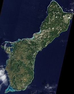
Guam is a U.S. territory in the western Pacific Ocean, at the boundary of the Philippine Sea. It is the southernmost and largest member of the Mariana Islands archipelago, which is itself the northernmost group of islands in Micronesia. The closest political entity is the Commonwealth of the Northern Mariana Islands (CNMI), another U.S. territory. Guam shares maritime boundaries with CNMI to the north and the Federated States of Micronesia to the south. It is located approximately one quarter of the way from the Philippines to Hawaii. Its location and size make it strategically important. It is the only island with both a protected harbor and land for multiple airports between Asia and Hawaii, on an east–west axis, and between Papua New Guinea and Japan, on a north–south axis.[2]
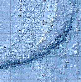
The island is a result of the volcanic activity created by subduction of the Pacific Plate under the Philippine Sea Plate at the nearby Mariana Trench, which runs from the east of Guam to the southwest. Volcanic eruptions established the base of the island in the Eocene, roughly 56 to 33.9 million years ago (mya). The north of Guam is a result of this base being covered with layers of coral reef, turning into limestone, and then being thrust by tectonic activity to create a plateau. The rugged south of the island is a result of more recent volcanic activity. Cocos Island off the southern tip of Guam is the largest of the many small islets along the coastline.
Politically, Guam is divided into 19 villages. The majority of the population lives on the coralline limestone plateaus of the north, with political and economic activity centered in the central and northern regions. The rugged geography of the south largely limits settlement to rural coastal areas. The western coast is leeward of the trade winds and is the location of Apra Harbor, the capitol Hagåtña, and the tourist center of Tumon. The U.S. Defense Department owns about 29% of the island,[3] under the management of Joint Region Marianas.
^The World Factbook: Guam Archived 2021-01-26 at the Wayback Machine CIA. Retrieved on October 18, 2017.
^Rogers, Robert F. (October 8, 2020). "Guam's Strategic Value". Guampedia. Archived from the original on March 10, 2021. Retrieved March 14, 2021.
^"Guam: Small But Important Piece of US Territory in Pacific | Voice of America - English". VOA News. August 9, 2017. Archived from the original on 10 March 2021. Retrieved 14 March 2021.
Guam is a U.S. territory in the western Pacific Ocean, at the boundary of the Philippine Sea. It is the southernmost and largest member of the Mariana...
United States, reckoned from the geographic center of the U.S. In Oceania, Guam is the largest and southernmost of the Mariana Islands and the largest...
taking of that village after World War II. List of census-designated places in Guam List of villages in the Northern Mariana Islands GeographyofGuam Village...
at the southern end of the chain, the territory ofGuam. The islands were named after the influential Spanish queen Mariana of Austria following their...
geology ofGuam formed as a result of mafic, felsic and intermediate composition volcanic rocks erupting below the ocean, building up the base of the island...
Alaska, Hawaii, the five insular territories of Puerto Rico, Northern Mariana Islands, U.S. Virgin Islands, Guam, American Samoa, and minor outlying possessions...
Survey, United States Department of the Interior. "Mount Lamlam". MountainZone.com One internet site GeographyofGuam claims the difference is 37,820...
This is a list ofgeographic centers of each U.S. state and inhabited territory. The geographic center of the United States is northeast of Belle Fourche...
The history ofGuam starts with the early arrival around 2000 BC of Austronesian people known today as the Chamorro Peoples. The Chamorus then developed...
provided as an overview of and topical guide to geography: Geography – study of Earth and its people. an academic discipline – a body of knowledge given to...
12 February 2010. Accessed Oct. 8, 2009 Geographyof the ocean floor near Guam with some notes on exploration of the Challenger Deep. A tiny worm sheds...
The Capture ofGuam was a bloodless engagement between the United States and Spain during the Spanish–American War. The U.S. Navy sent a single cruiser...
Talofofo Falls are a scenic series of cascades on the Ugum River on the island ofGuam. They are located in the southeast of the island, inland from Talofofo...
Air Force base located primarily within the village of Yigo in the United States territory ofGuam. The host unit at Andersen AFB is the 36th Wing (36...
Agrigan is a small island off the southern coast of the island ofGuam. It is connected to the mainland by the Merizo Barrier Reef. Bendure, G. & Friary...
The culture ofGuam reflects traditional Chamorro customs in a combination of indigenous pre-Hispanic forms, as well as American, Spanish and Mexican...
southern coast of the island ofGuam. It is connected to the mainland by the Merizo Barrier Reef. Cocos Lagoon List of rivers ofGuam National Centers...
original on December 27, 2011, retrieved October 20, 2011 "Guam | History, Geography, & Points of Interest". Encyclopedia Britannica. Archived from the original...
a number of other geographically isolated islands, Guam has problems with invasive species negatively affecting the natural biodiversity of the island...
 Global Information