 Global Information
Geography of Greater Manchester information

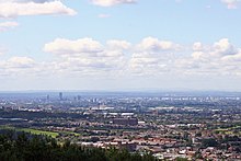
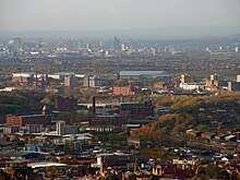
The geography of Greater Manchester is dominated by one of the United Kingdom's largest metropolitan areas, and in this capacity the landlocked metropolitan county constitutes one of the most urbanised and densely populated areas of the country. There is a mix of high density urban areas, suburbs, semi-rural and rural locations in Greater Manchester, but overwhelmingly the land use in the county is urban.[1]
Greater Manchester is a landlocked county spanning 492.7 sq mi (1,276 km2) (39th largest in England). The Pennines rise along the eastern side of the county, through parts of the boroughs of Oldham, Rochdale and Tameside. The West Pennine Moors, as well as a number of coalfields (mainly sandstones and shales) lie in the west of the county. The rivers Mersey, Irwell and Tame run through the county boundaries, each of which rise in the Pennines. Other rivers run through the county, including the Beal, the Douglas, the Etherow, the Goyt, the Irk, the Medlock and the Roch. Black Chew Head is the highest point of Greater Manchester, rising 542 metres (1,778 ft) above sea-level, within the parish of Saddleworth.[2] Chat Moss at 10.6 square miles (27 km2) comprises the largest area of Grade 1 and 2 farmland in Greater Manchester and contains the largest block of semi-natural woodland in the county.[3] Wardle is the most northerly settlement of Greater Manchester and Ramsden Clough the most northerly point; the suburb of Woodford the most southerly settlement and New Hall Farm (by the River Dean) the most southerly point.
Greater Manchester has a strong regional central business district, formed by Manchester City Centre and the adjoining parts of Salford and Trafford. However, Greater Manchester is also a polycentric county with ten metropolitan districts,[1] each of which has a major town centre – and in some cases more than one – and many smaller settlements. Greater Manchester is arguably the most complex urban area in the United Kingdom outside London,[1] and this is reflected in the density of its transport network and the scale of needs for investment to meet the growing and diverse movement demands generated by its development pattern.
- ^ a b c Greater Manchester Passenger Transport Authority. "The Greater Manchester Area and its Regional Context". gmltp.co.uk. Archived from the original on 27 September 2007. Retrieved 11 April 2007.
- ^ Dawson, A., (1992), The Relative Hills of Britain - Chapter 6: The County Tops, Cicerone Press, Milnthorpe, Cumbria.
- ^ Salford City Council (2007). "Chat Moss". salford.gov.uk. Archived from the original (http) on 28 September 2008. Retrieved 13 November 2007.