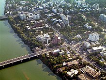
Ahmedabad is located on the banks of the River Sabarmati in the northern part of Gujarat and the western part of India. It is located at 23°02′N72°35′E / 23.03°N 72.58°E / 23.03; 72.58 spanning an area of 205 km2. The average elevation is 53 metres.
There are two main lakes located in the city limits – the Kankaria lake, and the Vastapur lake. Kankaria lake, located in Maninagar, is an artificial lake developed by Muhammad Shah II in 1451. It also has an aquarium and a zoo. In the middle of the lake is an island palace named Naginawadi, built during the Mughal era. The city is located in a sandy and dry area. Except for the small hills of Thaltej-Jodhpur Tekra, the entire city is almost flat. The Sabarmati bifurcates the city into eastern and western parts, connected by five bridges, two of which were constructed after independence. Though the river is perennial, it gets dried up in the summer, leaving only a small stream of water flowing.
There are typically three main seasons – summer, monsoon and winter. Barring monsoon, the climate is very dry. The weather is very hot during the months of March to June with the average summer temperature ranging from maximum 43 °C to minimum 23 °C. The months of November to February have an average maximum temperature 36 °C and a minimum of 15 °C. The climate is extremely dry during that period. Cold northerly winds are responsible for a mild chill during January. The south-west monsoon winds bring humid climate to Ahmedabad from mid-June to mid-September. The average rainfall is 932 mm.[1] The highest temperature recorded is 50 °C and the lowest is 5 °C.[2]
Ahmedabad is divided by the Sabarmati into two physically distinct areas. The eastern bank of the river houses the old city which has packed bazaars, a pol system of houses, and many places of worship like temples and mosques. The old city also houses the main railway station and the General Post Office. The colonial period saw the expansion of the city to the western side of Sabarmati facilitated by the construction of Ellis Bridge in 1875. This part of the city houses educational institutions, modern buildings, well-planned residential areas, shopping malls, multiplexes and new business districts centred on the C.G. Road, Ashram Road and more recently the Sarkhej-Gandhinagar Highway.
Sabarmati Ashram, also known as Gandhi Ashram, is located on the Western banks of Sabarmati River, in Northern Ahmedabad, was the residence of Mahatma Gandhi, and it was from there that he started the Dandi March in 1930. This ashram originally was established in the Kochrab area of Ahmedabad in 1915. In 1917 it was shifted to the present place. It also is known as Harijan Ashram, or Satyagraha Ashram. It was the scene of many events of the Indian independence movement.
^"Incredible India (Ahmedabad page)". Archived from the original on 28 September 2007. Retrieved 26 March 2006.
^"Weatherbase (Ahmedabad data)". Retrieved 8 May 2006.
and 22 Related for: Geography of Ahmedabad information
Ahmedabad is located on the banks of the River Sabarmati in the northern part of Gujarat and the western part of India. It is located at 23°02′N 72°35′E...
administrative headquarters of the Ahmedabad district and the seat of the Gujarat High Court. Ahmedabad's population of 5,570,585 (per the 2011 population...
Ahmedabad Junction railway station (station code: ADI), commonly known as Kalupur railway station, is the main railway station ofAhmedabad, Gujarat,...
the city ofAhmedabad and is joined by a left bank tributary, the Watrak River. The Sabarmati River continues to flow and drains into the Gulf of Khambhat...
Lake is the second largest lake in Ahmedabad in the Indian state of Gujarat. It is located in the south-eastern part of the city, in the Maninagar area....
Ahmedabad district or Amdavad district, is a district comprises the city of Amdavad, in the central part of the state of Gujarat in western India. It is...
Institute of Management Ahmedabad (IIM Ahmedabad or IIM-A), is an Indian business school, located in Ahmedabad, Gujarat, India. As one of India's premier...
Highway in Ahmedabad, Gujarat, India. The lake plot in Survey No. 251 of Chharodi village was transferred by Government of Gujarat to Ahmedabad Municipal...
Recreation Park, is an urban park in the Ambawadi area ofAhmedabad, Gujarat, India. It covers an area of 8.5 acres (34,000 m2). It was built in 1960, and redeveloped...
Ahmedabad, Gujarat, India. It was redeveloped in 1997. There is a street market of handicraft goods, street food and other goods along the walls of the...
western part ofAhmedabad in the Indian state of Gujarat. It is officially named after Narsinh Mehta. The lake was beautified by the Ahmedabad Municipal...
Ahmedabad Civil Hospital is a public hospital located in Ahmedabad, India, with facilities for specialised diagnostic, therapeutic and rehabilitative patient...
Ahmedabad City was a former taluk ofAhmedabad District in the western part of India state Gujarat. Around 19–20 March 2012, this taluk was bifurcated...
an urban park in Bopal-Ghuma neighbourhood in Ahmedabad, Gujarat, India. It is spread over an area of 22,000 square metres (5.4 acres) and was opened...
Darwaja or Gates ofAhmedabad were built during different times starting from 1411 as the entrances to the walled city ofAhmedabad, Gujarat, India. These...
conglomerate, based in Ahmedabad. It was founded by Uttambhai Nathalal Mehta, and now run by his sons, Sudhir and Samir Mehta. The core businesses of the group are...
मंदिर) is one of the biggest Hanuman temples in India. It is situated in Ahmedabad Cantonment in Shahibaug, Ahmedabad in the Indian state of Gujarat. The...
and the Pakistani province of Sindh to the west. Gujarat's capital city is Gandhinagar, while its largest city is Ahmedabad. The Gujaratis are indigenous...
foothills of the Himalayas in northeast India. It is spread over an area of 83,743 km2 (32,333 sq mi). 98% of the geographical area is land out of which 80%...
under Lucknow Municipal Corporation to 631 sqkm "Ahmedabad to get 70 sq km bigger". Times of India. Ahmedabad. 28 November 2019. Archived from the original...
Ahmedabad district of Gujarat state in India. Dholera was also an ancient port-city in Gulf of Khambhat, 30 km. from Dhandhuka village ofAhmedabad district...
Ambawadi is an area located in Ahmedabad, India. The major landmarks of the area are the Ahmedabad Central Mall, the Ambawadi shaak bazaar (vegetable...
 Global Information