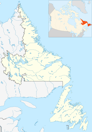
Location of Fogo Island Radar Station, Newfoundland
Map all coordinates using OpenStreetMap
Download coordinates as:
KML
GPX (all coordinates)
GPX (primary coordinates)
GPX (secondary coordinates)
Fogo Island Radar Station (Quad) was a United States Army General Surveillance Ground Radar Early Warning Station in the Dominion of Newfoundland.[1][2] It was built during World War II and responsible for monitoring air traffic from Gander to Goose Bay and into the Atlantic Ocean.[3] It was located in Sandy Cove, Fogo Island 260 kilometres (160 mi) north-northwest of St. John's.[4] It was closed in 1945.[5]
^"A Handbook of Aerospace Defense Organization 1946 – 1980" (PDF). Archived from the original (PDF) on 13 February 2016. Retrieved 21 December 2022.
^"Other American Stations". www.heritage.nf.ca.
^"Newfoundland Forts".
^"The first United States Ground Radar Early Warning Station in the North Atlantic area at Sandy Cove, Fogo Island, Newfoundland".
^"The CADIN Pinetree Line Locations".
and 26 Related for: Fogo Island Radar Station information
military bases "Other American Stations". Heritage.nf.ca. Retrieved 2023-02-10. "THE U-BOAT ATTACKS ON THE BELL ISLAND ORE SHIPS IN 1942". Heritage.nf...
Newfoundland Allan's IslandRadarStation Bell Island Battery Cape Spear RadarStation Elliston Ridge RadarStationFogoIslandRadarStation Goose Bay Army...
VOI Makkovik VOJ Fogo (1912–1933) VOJH Corner Brook (1940–1974) VON Cabot Tower/Signal Hill, St. John's (until 1960) All radio stations licensed by the...
(secondary coordinates) Cut Throat Island Air Station (ADC ID: N-27A) was a General Surveillance Gap Filler Radarstation in the Canadian province of Newfoundland...
(secondary coordinates) Spotted Island Air Station (ADC ID: N-27B) was a General Surveillance Gap Filler Radarstation in the Canadian province of Newfoundland...
firing and sinking the ship immediately off the island with all hands and all cargo lost. The Cabeço do Fogo Volcano erupted in 1672, leading to substantial...
(secondary coordinates) Cartwright Air Station (ADC ID: N-27) is a closed General Surveillance Radarstation. It is located 233.7 km (145.2 mi) east-northeast...
Radar site is built 21.7 kilometres (13.5 mi) south of Cartwright Air Station, which was established in 1953 as a General Surveillance Radarstation,...
in the area. Cape Spear RadarStation (Prime) was a United States Army General Surveillance Ground Radar Early Warning Station in the Dominion of Newfoundland...
Naval Station Argentia (IATA: NWP) is a former base of the United States Navy that operated from 1941 to 1994. It was established in the community of...
About NORAD Public information Radar Information AN/FPS-117 Radar information from FAS Technical Radar Information AN/FPS-124 Radar information from FAS...
the western North Atlantic and southern Arctic and a Canadian Coastal Radarstation amongst other things. It is home to 9 Wing Gander. CFB Gander is co-located...
About NORAD Public information Radar Information AN/FPS-117 Radar information from FAS Technical Radar Information AN/FPS-124 Radar information from FAS...
About NORAD Public information Radar Information AN/FPS-117 Radar information from FAS Technical Radar Information AN/FPS-124 Radar information from FAS...
Early Warning Radar Line". http://www.lswilson.ca/dewline.htm#L The DEW LINE About NORAD Public information Radar Information AN/FPS-117 Radar information...
que mistura conceitos de "Pokémon", "Minecraft" e "Fortnite" com armas de fogo pesadas e piadas de duplo sentido — exclusivas para a localização em português...
"landed" outside the United States. In 1988, the Pinetree Line radar site (Melville Air Station) adjacent to CFB Goose Bay was closed. Goose Bay experienced...
coordinates) GPX (secondary coordinates) Hopedale Air Station (ADC ID: N-28) is a General Surveillance Radarstation that the USAF closed in 1968. It is located...
Global, 13–19 December 2011. Retrieved: 10 January 2012 "FAB ganha poder de fogo com 'novo' caça" (in Portuguese). Archived 29 January 2012 at the Wayback...
CFS Saglek Canadian Forces Station Saglek is a Royal Canadian Air Force radar base in the former Pinetree Line and currently part of the North Warning...
(secondary coordinates) Red Cliff Air Station (Also known as St. Johns) (ID: N-22, C-22) was a General Surveillance Radarstation. The remains of which are located...
2013. Godoy, Roberto (13 July 2012). "A-29 da Embraer é a plataforma de fogo contra a guerrilha". Estadão (in Portuguese). Defesa Net. Archived from the...
government of Cape Verde issued tropical storm warnings for the islands of Brava, Fogo, and Santiago. Domestic airlines cancelled 20 flights on August 31...
 Global Information